Property Record
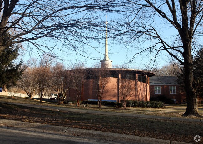
3211 Paul Dr, Silver Spring, MD 20902


Property Detail
3211 Paul Dr
13-01407100
PL 3723 PAR A MONTG HIGHLA ND EST
Religious
Montgomery
R60
Maryland
B and X Area of moderate flood hazard, usually the area between the limits of the 100-year and 500-year floods.
a
2024
2.89 AC
2025
Kensington/Wheaton
703701
Washington, DC
24,770 SF
Washington-Arlington-Alexandria, DC-VA-MD-WV
NEARBY LISTINGS FOR SALE OR LEASE
-
-
View all Silver Spring listings for sale on LoopNet.com
DEMOGRAPHICS near 3211 Paul Dr
1 mile
3 mile
5 mile
2025 Total Population
27,380
182,350
448,542
2030 Population
28,070
187,552
462,518
Pop Growth 2025-2030
+ 2.52%
+ 2.85%
+ 3.12%
Average Age
39
40
41
2025 Total Households
8,645
64,663
171,472
HH Growth 2025-2030
+ 2.59%
+ 2.87%
+ 3.25%
Median Household Inc
$108,113
$118,369
$120,741
Avg Household Size
3.00
2.70
2.50
2025 Avg HH Vehicles
2.00
2.00
2.00
Median Home Value
$488,765
$617,145
$665,377
Median Year Built
1957
1966
1968
Nearby Places
Map Layers
Map Styles
 Street
 Aerial
Transit
 Traffic
 Biking
Places
Listings with unknown addresses are not visible on the map
- Restaurants
- Banks
- Shops
- Fitness
- Groceries
PUBLIC TRANSPORTATION
COMMUTER RAIL
Kensington Marc Eb (BRUNSWICK - WASHINGTON - Maryland Transit Administration)
Drive
Walk
Distance
Kensington Marc Eb (BRUNSWICK - WASHINGTON - Maryland Transit Administration)
5 min
1.9 mi
Garrett Park Marc Eb (BRUNSWICK - WASHINGTON - Maryland Transit Administration)
Drive
Walk
Distance
Garrett Park Marc Eb (BRUNSWICK - WASHINGTON - Maryland Transit Administration)
9 min
3.1 mi
AIRPORT
Ronald Reagan Washington Ntl
Drive
Walk
Distance
Ronald Reagan Washington Ntl
31 min
16.1 mi
Washington Dulles International
Drive
Walk
Distance
Washington Dulles International
48 min
29.1 mi
Baltimore/Washington International Thurgood Marshall
Drive
Walk
Distance
Baltimore/Washington International Thurgood Marshall
44 min
31.5 mi
Freight Ports
Port of Baltimore
Drive
Walk
Distance
Port of Baltimore
49 min
34.3 mi
Nearby Properties
Address
Land Use
TOTAL SIZE
Lot Size
Zoning
Address
Land Use
TOTAL SIZE
Lot Size
Zoning
1,332,482 SF
3.79 AC
CR2.0
Address
Land Use
TOTAL SIZE
Lot Size
Zoning
775,490 SF
14.21 AC
R60
Address
Land Use
TOTAL SIZE
Lot Size
Zoning
1,775,186 SF
75.19 AC
GR1.5
Address
Land Use
TOTAL SIZE
Lot Size
Zoning
1,119,608 SF
90.30 AC
R90
Address
Land Use
TOTAL SIZE
Lot Size
Zoning
178,124 SF
11 AC
R60
Address
Land Use
TOTAL SIZE
Lot Size
Zoning
515,000 SF
5.23 AC
CR1.5
Address
Land Use
TOTAL SIZE
Lot Size
Zoning
432,000 SF
1.77 AC
CR4.0
Address
Land Use
TOTAL SIZE
Lot Size
Zoning
379,100 SF
11.80 AC
CR4.0
Address
Land Use
TOTAL SIZE
Lot Size
Zoning
626,132 SF
7.28 AC
CR0.5
Address
Land Use
TOTAL SIZE
Lot Size
Zoning
380,452 SF
2.38 AC
CR3.0
Address
Land Use
TOTAL SIZE
Lot Size
Zoning
431,630 SF
25.77 AC
R60
Address
Land Use
TOTAL SIZE
Lot Size
Zoning
364,000 SF
CR6.0
Address
Land Use
TOTAL SIZE
Lot Size
Zoning
379,878 SF
2.13 AC
CR
Address
Land Use
TOTAL SIZE
Lot Size
Zoning
815,414 SF
3.27 AC
CR4.0
Address
Land Use
TOTAL SIZE
Lot Size
Zoning
674,400 SF
3.21 AC
CR3.0
Address
Land Use
TOTAL SIZE
Lot Size
Zoning
223,520 SF
2.77 AC
CR2.0
Address
Land Use
TOTAL SIZE
Lot Size
Zoning
291,194 SF
0.72 AC
CR4.0
Address
Land Use
TOTAL SIZE
Lot Size
Zoning
454,275 SF
1.12 AC
CR7.2
Address
Land Use
TOTAL SIZE
Lot Size
Zoning
465,983 SF
1.38 AC
CR3.0
Address
Land Use
TOTAL SIZE
Lot Size
Zoning
643,335 SF
29.18 AC
R20
Address
Land Use
TOTAL SIZE
Lot Size
Zoning
429,137 SF
1.80 AC
CR4.0
Address
Land Use
TOTAL SIZE
Lot Size
Zoning
460,492 SF
3.56 AC
CR4.0
Address
Land Use
TOTAL SIZE
Lot Size
Zoning
152,330 SF
CR
Address
Land Use
TOTAL SIZE
Lot Size
Zoning
291,945 SF
10.49 AC
R10
Address
Land Use
TOTAL SIZE
Lot Size
Zoning
418,657 SF
CR4.0
Address
Land Use
TOTAL SIZE
Lot Size
Zoning
276,462 SF
15.11 AC
R60
Address
Land Use
TOTAL SIZE
Lot Size
Zoning
244,934 SF
3.59 AC
CRT2.
Address
Land Use
TOTAL SIZE
Lot Size
Zoning
164,307 SF
16.45 AC
R90
Address
Land Use
TOTAL SIZE
Lot Size
Zoning
664,858 SF
106.79 AC
R90
Address
Land Use
TOTAL SIZE
Lot Size
Zoning
353,684 SF
2.48 AC
CR4.0
The World's #1 Commercial Real Estate Marketplace
Connect with us
© 2026 CoStar Group
The information above has been obtained from sources believed reliable. While we do not doubt its accuracy we have not verified it and make no guarantee, warranty or representation about it. It is your responsibility to independently confirm its accuracy and completeness. Any projections, opinions, assumptions, or estimates used are for example only and do not represent the current or future performance of the property. The value of this transaction to you depends on tax and other factors which should be evaluated by your tax, financial, and legal advisors. You and your advisors should conduct a careful, independent investigation of the property to determine to your satisfaction the suitability of the property for your needs.