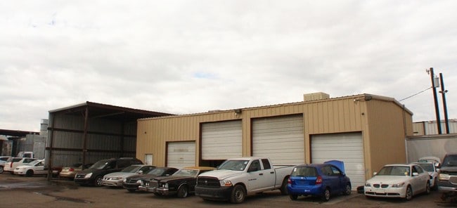
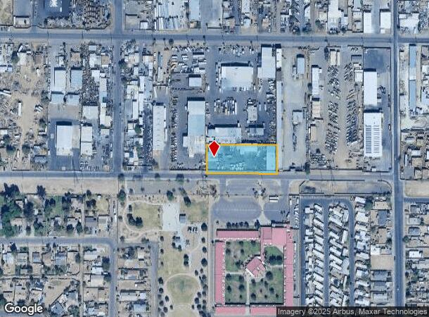
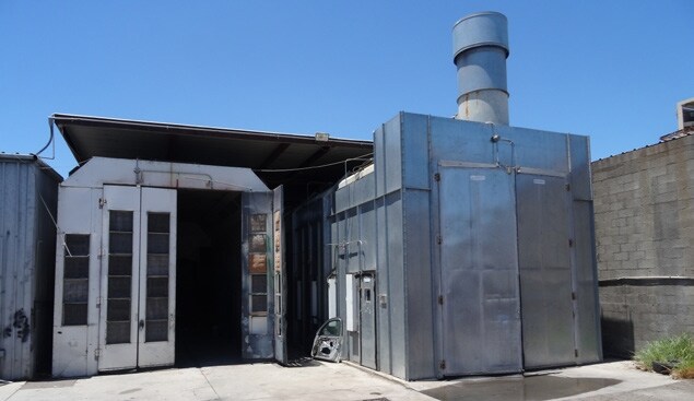
Property Record
3212 W Sherman St, Phoenix, AZ 85009

NEARBY LISTINGS FOR SALE OR LEASE
Property Detail
3212 W Sherman St
Phoenix-Mesa-Chandler, AZ
Capitol Heights 1 Through 16
109-56-021A
CAPITOL HEIGHTS 1 THROUGH 16 MCR 18/10
Commercialnec
Maricopa
X
Arizona
04013C2185L
8
2025
1 AC
2025
SW N of Buckeye Road
114500
Phoenix
4,751 SF
DEMOGRAPHICS near 3212 W Sherman St
1 Mile
3 Mile
5 Mile
2024 Total Population
10,489
73,320
345,155
2029 Population
11,198
78,912
373,225
Pop Growth 2024-2029
+ 6.76%
+ 7.63%
+ 8.13%
Average Age
33
34
33
2024 Total Households
2,740
22,657
110,658
HH Growth 2024-2029
+ 6.68%
+ 7.89%
+ 8.75%
Median Household Inc
$40,316
$43,187
$52,888
Avg Household Size
3.50
3.00
2.90
2024 Avg HH Vehicles
2.00
2.00
2.00
Median Home Value
$113,809
$224,613
$271,517
Median Year Built
1957
1966
1975
Nearby Places
Map Layers
Map Styles
 Street
 Aerial
- Restaurants
- Banks
- Shops
- Fitness
- Groceries
PUBLIC TRANSPORTATION
AIRPORT
Phoenix Sky Harbor International
DRIVE
WALK
Distance
Phoenix Sky Harbor International
18 min
9.1 mi
Phoenix-Mesa Gateway
DRIVE
WALK
Distance
Phoenix-Mesa Gateway
49 min
35.0 mi
SALE & LEASE HISTORY
LISTING DATE
SALE/LEASE

Sep 23, 2016
For Sale
Feb 23, 2017
For Sale
Nearby Properties
Address
Land Use
TOTAL SIZE
Lot Size
Zoning
Address
Land Use
TOTAL SIZE
Lot Size
Zoning
270,000 SF
12.90 AC
I-1
Address
Land Use
TOTAL SIZE
Lot Size
Zoning
577,883 SF
2.05 AC
C-DT
Address
Land Use
TOTAL SIZE
Lot Size
Zoning
781,334 SF
59.96 AC
I-1
Address
Land Use
TOTAL SIZE
Lot Size
Zoning
182,984 SF
146.12 AC
I-1
Address
Land Use
TOTAL SIZE
Lot Size
Zoning
568,512 SF
6.99 AC
C-DT
Address
Land Use
TOTAL SIZE
Lot Size
Zoning
1,378,775 SF
86.09 AC
M-H
Address
Land Use
TOTAL SIZE
Lot Size
Zoning
91,000 SF
7.57 AC
I-1
Address
Land Use
TOTAL SIZE
Lot Size
Zoning
86,350 SF
25.82 AC
I-1
Address
Land Use
TOTAL SIZE
Lot Size
Zoning
429,457 SF
9.41 AC
C-DT
Address
Land Use
TOTAL SIZE
Lot Size
Zoning
384,291 SF
2.68 AC
C-DT
Address
Land Use
TOTAL SIZE
Lot Size
Zoning
33.15 AC
Address
Land Use
TOTAL SIZE
Lot Size
Zoning
20,430 SF
24.57 AC
I-1
Address
Land Use
TOTAL SIZE
Lot Size
Zoning
440,160 SF
42.43 AC
A1
Address
Land Use
TOTAL SIZE
Lot Size
Zoning
610,451 SF
4.21 AC
C-C
Address
Land Use
TOTAL SIZE
Lot Size
Zoning
69,542 SF
4.92 AC
I-P
Address
Land Use
TOTAL SIZE
Lot Size
Zoning
377,037 SF
35.46 AC
R1-6
Address
Land Use
TOTAL SIZE
Lot Size
Zoning
1,205,743 SF
59.34 AC
I-1
Address
Land Use
TOTAL SIZE
Lot Size
Zoning
316,491 SF
2.16 AC
C-DT
Address
Land Use
TOTAL SIZE
Lot Size
Zoning
349,188 SF
2.06 AC
C-DT
Address
Land Use
TOTAL SIZE
Lot Size
Zoning
416,837 SF
5.35 AC
C-2
Address
Land Use
TOTAL SIZE
Lot Size
Zoning
42,631 SF
2.90 AC
A-2
Address
Land Use
TOTAL SIZE
Lot Size
Zoning
665,659 SF
3.33 AC
I-1
Address
Land Use
TOTAL SIZE
Lot Size
Zoning
335,897 SF
2.07 AC
R-5
Address
Land Use
TOTAL SIZE
Lot Size
Zoning
550,683 SF
1.98 AC
C-C
Address
Land Use
TOTAL SIZE
Lot Size
Zoning
250,448 SF
3.59 AC
C-3
Address
Land Use
TOTAL SIZE
Lot Size
Zoning
14.16 AC
Address
Land Use
TOTAL SIZE
Lot Size
Zoning
637,878 SF
5.93 AC
R-4
Address
Land Use
TOTAL SIZE
Lot Size
Zoning
449,802 SF
27.08 AC
A-1
Address
Land Use
TOTAL SIZE
Lot Size
Zoning
532,119 SF
2.79 AC
DTCVANB
Address
Land Use
TOTAL SIZE
Lot Size
Zoning
144,015 SF
3.71 AC
C-DT
The World's #1 Commercial Real Estate Marketplace
Connect with us
© 2026 CoStar Group
The information above has been obtained from sources believed reliable. While we do not doubt its accuracy we have not verified it and make no guarantee, warranty or representation about it. It is your responsibility to independently confirm its accuracy and completeness. Any projections, opinions, assumptions, or estimates used are for example only and do not represent the current or future performance of the property. The value of this transaction to you depends on tax and other factors which should be evaluated by your tax, financial, and legal advisors. You and your advisors should conduct a careful, independent investigation of the property to determine to your satisfaction the suitability of the property for your needs.