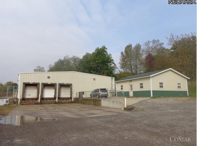
Property Record
3213 Magnolia Rd Nw, Magnolia, OH 44643

NEARBY LISTINGS FOR SALE OR LEASE
-
-
View all Magnolia listings for sale on LoopNet.com
Property Detail
3213 Magnolia Rd Nw
31-0000595.002
7 16 29 PT NW 6.035A
Assemblylightindustrial
Carroll
X
Ohio
39157C0100E
6.04 AC
2024
Carroll County
2024
Cleveland
720400
Canton-Massillon, OH
5,600 SF
DEMOGRAPHICS near 3213 Magnolia Rd Nw
1 Mile
3 Mile
5 Mile
2024 Total Population
60
2,488
7,573
2029 Population
58
2,396
7,327
Pop Growth 2024-2029
(3.33%)
(3.70%)
(3.25%)
Average Age
43
42
42
2024 Total Households
26
987
3,042
HH Growth 2024-2029
(3.85%)
(3.75%)
(3.32%)
Median Household Inc
$59,999
$59,942
$56,837
Avg Household Size
2.40
2.50
2.50
2024 Avg HH Vehicles
2.00
2.00
2.00
Median Home Value
$199,999
$158,406
$154,006
Median Year Built
1969
1956
1960
Nearby Places
Map Layers
Map Styles
 Street
 Aerial
- Restaurants
- Banks
- Shops
- Fitness
- Groceries
PUBLIC TRANSPORTATION
AIRPORT
Akron-Canton Regional
DRIVE
WALK
Distance
Akron-Canton Regional
36 min
24.3 mi
Nearby Properties
Address
Land Use
TOTAL SIZE
Lot Size
Zoning
Address
Land Use
TOTAL SIZE
Lot Size
Zoning
27,063 SF
3.22 AC
Address
Land Use
TOTAL SIZE
Lot Size
Zoning
12,044 SF
6.64 AC
Address
Land Use
TOTAL SIZE
Lot Size
Zoning
12,882 SF
4.88 AC
Address
Land Use
TOTAL SIZE
Lot Size
Zoning
1,200 SF
164.42 AC
Address
Land Use
TOTAL SIZE
Lot Size
Zoning
11,532 SF
5.79 AC
Address
Land Use
TOTAL SIZE
Lot Size
Zoning
3,476 SF
35.58 AC
Address
Land Use
TOTAL SIZE
Lot Size
Zoning
924 SF
252.74 AC
Address
Land Use
TOTAL SIZE
Lot Size
Zoning
246.74 AC
Address
Land Use
TOTAL SIZE
Lot Size
Zoning
1,940 SF
147.91 AC
Address
Land Use
TOTAL SIZE
Lot Size
Zoning
3,080 SF
117.47 AC
Address
Land Use
TOTAL SIZE
Lot Size
Zoning
7,880 SF
79.92 AC
Address
Land Use
TOTAL SIZE
Lot Size
Zoning
137.10 AC
Address
Land Use
TOTAL SIZE
Lot Size
Zoning
22,532 SF
3.49 AC
Address
Land Use
TOTAL SIZE
Lot Size
Zoning
2,190 SF
81.50 AC
Address
Land Use
TOTAL SIZE
Lot Size
Zoning
4,123 SF
73.57 AC
Address
Land Use
TOTAL SIZE
Lot Size
Zoning
5,852 SF
0.45 AC
Address
Land Use
TOTAL SIZE
Lot Size
Zoning
15,208 SF
0.58 AC
Address
Land Use
TOTAL SIZE
Lot Size
Zoning
4,102 SF
16.40 AC
Address
Land Use
TOTAL SIZE
Lot Size
Zoning
33,220 SF
11.56 AC
Address
Land Use
TOTAL SIZE
Lot Size
Zoning
8,868 SF
0.66 AC
Address
Land Use
TOTAL SIZE
Lot Size
Zoning
95.65 AC
Address
Land Use
TOTAL SIZE
Lot Size
Zoning
282.08 AC
Address
Land Use
TOTAL SIZE
Lot Size
Zoning
700 SF
112.71 AC
Address
Land Use
TOTAL SIZE
Lot Size
Zoning
93.04 AC
Address
Land Use
TOTAL SIZE
Lot Size
Zoning
27,288 SF
4.83 AC
Address
Land Use
TOTAL SIZE
Lot Size
Zoning
6,244 SF
0.28 AC
Address
Land Use
TOTAL SIZE
Lot Size
Zoning
7,977 SF
98.96 AC
Address
Land Use
TOTAL SIZE
Lot Size
Zoning
1,476 SF
60.57 AC
Address
Land Use
TOTAL SIZE
Lot Size
Zoning
1,512 SF
49.22 AC
The World's #1 Commercial Real Estate Marketplace
Connect with us
© 2026 CoStar Group
The information above has been obtained from sources believed reliable. While we do not doubt its accuracy we have not verified it and make no guarantee, warranty or representation about it. It is your responsibility to independently confirm its accuracy and completeness. Any projections, opinions, assumptions, or estimates used are for example only and do not represent the current or future performance of the property. The value of this transaction to you depends on tax and other factors which should be evaluated by your tax, financial, and legal advisors. You and your advisors should conduct a careful, independent investigation of the property to determine to your satisfaction the suitability of the property for your needs.