Property Record
3214 S New Hope Rd, Gastonia, NC 28056


NEARBY LISTINGS FOR SALE OR LEASE
Property Detail
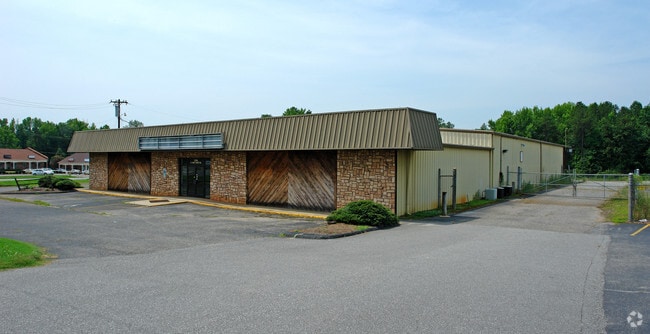
3214 S New Hope Rd
149319
Boundary Survey For C Donnie Cann Wilson
Storebuilding
10 121 022 03 000
X
Gaston
3710356400J
North Carolina
2025
5.02 AC
2025
Gaston County
032506
Charlotte
16,921 SF
Charlotte-Concord-Gastonia, NC-SC
DEMOGRAPHICS near 3214 S New Hope Rd
1 Mile
3 Mile
5 Mile
2024 Total Population
5,578
41,869
98,628
2029 Population
5,951
44,709
105,575
Pop Growth 2024-2029
+ 6.69%
+ 6.78%
+ 7.04%
Average Age
39
41
40
2024 Total Households
2,101
16,932
39,930
HH Growth 2024-2029
+ 6.81%
+ 7.00%
+ 7.23%
Median Household Inc
$87,348
$73,384
$62,515
Avg Household Size
2.70
2.40
2.40
2024 Avg HH Vehicles
2.00
2.00
2.00
Median Home Value
$247,404
$254,598
$238,023
Median Year Built
2000
1989
1984
Nearby Places
Map Layers
Map Styles
 Street
 Aerial
- Restaurants
- Banks
- Shops
- Fitness
- Groceries
PUBLIC TRANSPORTATION
COMMUTER RAIL
Gastonia Amtrak Station (Crescent - Amtrak)
DRIVE
WALK
Distance
Gastonia Amtrak Station (Crescent - Amtrak)
10 min
4.9 mi
AIRPORT
Charlotte/Douglas International
DRIVE
WALK
Distance
Charlotte/Douglas International
28 min
15.2 mi
Concord-Padgett Regional
DRIVE
WALK
Distance
Concord-Padgett Regional
43 min
31.6 mi
Freight Ports
North Charleston Terminal
DRIVE
WALK
Distance
North Charleston Terminal
238 min
201.2 mi
Nearby Properties
Address
Land Use
TOTAL SIZE
Lot Size
Zoning
Address
Land Use
TOTAL SIZE
Lot Size
Zoning
104.72 AC
Address
Land Use
TOTAL SIZE
Lot Size
Zoning
1,886 SF
39.30 AC
Address
Land Use
TOTAL SIZE
Lot Size
Zoning
25,137 SF
34.81 AC
Address
Land Use
TOTAL SIZE
Lot Size
Zoning
54.70 AC
Address
Land Use
TOTAL SIZE
Lot Size
Zoning
47,625 SF
39.10 AC
SHOP2
Address
Land Use
TOTAL SIZE
Lot Size
Zoning
3,026 SF
32.14 AC
HCAR3
Address
Land Use
TOTAL SIZE
Lot Size
Zoning
30,906 SF
14.19 AC
Address
Land Use
TOTAL SIZE
Lot Size
Zoning
7,880 SF
18.35 AC
R1
Address
Land Use
TOTAL SIZE
Lot Size
Zoning
28.04 AC
Address
Land Use
TOTAL SIZE
Lot Size
Zoning
30,000 SF
18.87 AC
SHOP2
Address
Land Use
TOTAL SIZE
Lot Size
Zoning
5,200 SF
22.98 AC
OFF01
Address
Land Use
TOTAL SIZE
Lot Size
Zoning
8,040 SF
18.44 AC
APT01
Address
Land Use
TOTAL SIZE
Lot Size
Zoning
3,120 SF
15.05 AC
OFF01
Address
Land Use
TOTAL SIZE
Lot Size
Zoning
1,886 SF
13.27 AC
APT01
Address
Land Use
TOTAL SIZE
Lot Size
Zoning
1,974 SF
15.50 AC
APT01
Address
Land Use
TOTAL SIZE
Lot Size
Zoning
8,960 SF
12.67 AC
Address
Land Use
TOTAL SIZE
Lot Size
Zoning
20.41 AC
Address
Land Use
TOTAL SIZE
Lot Size
Zoning
13,800 SF
58.55 AC
PUB01
Address
Land Use
TOTAL SIZE
Lot Size
Zoning
1,868 SF
15.93 AC
OFF01
Address
Land Use
TOTAL SIZE
Lot Size
Zoning
5,120 SF
9.42 AC
Address
Land Use
TOTAL SIZE
Lot Size
Zoning
18,803 SF
9.57 AC
SHOP3
Address
Land Use
TOTAL SIZE
Lot Size
Zoning
33,258 SF
5.51 AC
Address
Land Use
TOTAL SIZE
Lot Size
Zoning
198,897 SF
10.89 AC
RET05
Address
Land Use
TOTAL SIZE
Lot Size
Zoning
1,170 SF
320.29 AC
OFF01
Address
Land Use
TOTAL SIZE
Lot Size
Zoning
6,774 SF
13.86 AC
APT02
Address
Land Use
TOTAL SIZE
Lot Size
Zoning
140,740 SF
17.45 AC
RET05
Address
Land Use
TOTAL SIZE
Lot Size
Zoning
44,718 SF
26.53 AC
OFF10
Address
Land Use
TOTAL SIZE
Lot Size
Zoning
90,705 SF
10.30 AC
Address
Land Use
TOTAL SIZE
Lot Size
Zoning
960 SF
7.33 AC
APT02
Address
Land Use
TOTAL SIZE
Lot Size
Zoning
1,721 SF
17.49 AC
OFF01
The World's #1 Commercial Real Estate Marketplace
Connect with us
© 2026 CoStar Group
The information above has been obtained from sources believed reliable. While we do not doubt its accuracy we have not verified it and make no guarantee, warranty or representation about it. It is your responsibility to independently confirm its accuracy and completeness. Any projections, opinions, assumptions, or estimates used are for example only and do not represent the current or future performance of the property. The value of this transaction to you depends on tax and other factors which should be evaluated by your tax, financial, and legal advisors. You and your advisors should conduct a careful, independent investigation of the property to determine to your satisfaction the suitability of the property for your needs.