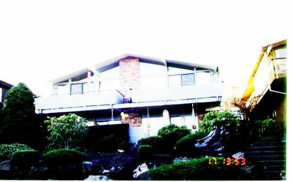
Property Record
3214 W Barrett St, Seattle, WA 98199
NEARBY LISTINGS FOR SALE OR LEASE
Property Detail
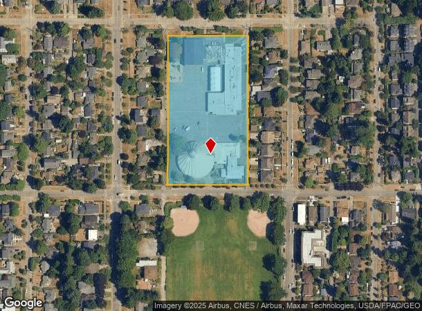
3214 W Barrett St
Seattle-Tacoma-Bellevue, WA
Pleasant Valley Add No. 02
682210-0520
PLEASANT VALLEY ADD # 2 12 THRU 22 BLK 31 & LOTS 1 THRU 11 BLK 32 & VAC ST ADJ
Religious
King
X
Washington
53033C0320G
1-11
2021
4.01 AC
2024
Lawton Park
005700
Seattle/Puget Sound
56,568 SF
DEMOGRAPHICS near 3214 W Barrett St
1 Mile
3 Mile
5 Mile
2024 Total Population
20,659
143,720
419,727
2029 Population
20,729
145,095
426,626
Pop Growth 2024-2029
+ 0.34%
+ 0.96%
+ 1.64%
Average Age
40
38
37
2024 Total Households
8,864
71,255
215,971
HH Growth 2024-2029
+ 0.18%
+ 0.92%
+ 1.75%
Median Household Inc
$158,281
$128,730
$115,304
Avg Household Size
2.30
1.90
1.80
2024 Avg HH Vehicles
2.00
1.00
1.00
Median Home Value
$1,043,544
$979,883
$953,379
Median Year Built
1959
1973
1982
Nearby Places
Map Layers
Map Styles
 Street
 Aerial
- Restaurants
- Banks
- Shops
- Fitness
- Groceries
PUBLIC TRANSPORTATION
COMMUTER RAIL
King Street (Seattle) Station (Everett - Seattle - Sound Transit, Seattle - Tacoma/Lakewood - Sound Transit, Sounder South Line - Sound Transit)
DRIVE
WALK
Distance
King Street (Seattle) Station (Everett - Seattle - Sound Transit, Seattle - Tacoma/Lakewood - Sound Transit, Sounder South Line - Sound Transit)
17 min
5.5 mi
AIRPORT
Seattle-Tacoma International
DRIVE
WALK
Distance
Seattle-Tacoma International
38 min
19.9 mi
Seattle Paine Field International
DRIVE
WALK
Distance
Seattle Paine Field International
44 min
24.6 mi
Freight Ports
Port of Seattle
DRIVE
WALK
Distance
Port of Seattle
22 min
8.7 mi
Nearby Properties
Address
Land Use
TOTAL SIZE
Lot Size
Zoning
Address
Land Use
TOTAL SIZE
Lot Size
Zoning
800,000 SF
8.57 AC
SM-UP 95 (
Address
Land Use
TOTAL SIZE
Lot Size
Zoning
9,956 SF
193.53 AC
NR2
Address
Land Use
TOTAL SIZE
Lot Size
Zoning
36,864 SF
8.02 AC
SM-UP 95 (
Address
Land Use
TOTAL SIZE
Lot Size
Zoning
565,110 SF
29.11 AC
II U/85
Address
Land Use
TOTAL SIZE
Lot Size
Zoning
155,795 SF
7.89 AC
SM-UP 95 (
Address
Land Use
TOTAL SIZE
Lot Size
Zoning
5,073 SF
25.99 AC
II U/85
Address
Land Use
TOTAL SIZE
Lot Size
Zoning
6,740 SF
46.38 AC
C2-55 (M)
Address
Land Use
TOTAL SIZE
Lot Size
Zoning
1,936 SF
83.77 AC
MML U/45
Address
Land Use
TOTAL SIZE
Lot Size
Zoning
430,191 SF
8.85 AC
SM-UP 95 (
Address
Land Use
TOTAL SIZE
Lot Size
Zoning
15,450 SF
6.54 AC
SM-UP 95 (
Address
Land Use
TOTAL SIZE
Lot Size
Zoning
42,500 SF
90.92 AC
NR3
Address
Land Use
TOTAL SIZE
Lot Size
Zoning
14 AC
LR3 (M)
Address
Land Use
TOTAL SIZE
Lot Size
Zoning
241,955 SF
12.81 AC
LR2 (M)
Address
Land Use
TOTAL SIZE
Lot Size
Zoning
6.30 AC
SM-UP 95 (
Address
Land Use
TOTAL SIZE
Lot Size
Zoning
12,544 SF
99.44 AC
C1-40
Address
Land Use
TOTAL SIZE
Lot Size
Zoning
13,370 SF
31.99 AC
NR2
Address
Land Use
TOTAL SIZE
Lot Size
Zoning
227,088 SF
1.64 AC
NC3-75 (M)
Address
Land Use
TOTAL SIZE
Lot Size
Zoning
79,572 SF
27.40 AC
MML U/45
Address
Land Use
TOTAL SIZE
Lot Size
Zoning
513,816 SF
0.77 AC
SM-SLU 100
Address
Land Use
TOTAL SIZE
Lot Size
Zoning
65,643 SF
53.62 AC
MML U/45
Address
Land Use
TOTAL SIZE
Lot Size
Zoning
20,289 SF
10.76 AC
MIO-50-LR3
Address
Land Use
TOTAL SIZE
Lot Size
Zoning
210,103 SF
1.03 AC
NC3P-95 (M
Address
Land Use
TOTAL SIZE
Lot Size
Zoning
396,085 SF
3.15 AC
SM-UP 95 (
Address
Land Use
TOTAL SIZE
Lot Size
Zoning
232,656 SF
0.89 AC
SM-SLU 100
Address
Land Use
TOTAL SIZE
Lot Size
Zoning
346.43 AC
NR2
Address
Land Use
TOTAL SIZE
Lot Size
Zoning
198,888 SF
1.19 AC
II U/85
Address
Land Use
TOTAL SIZE
Lot Size
Zoning
193,404 SF
1.20 AC
SM-SLU 100
Address
Land Use
TOTAL SIZE
Lot Size
Zoning
199,018 SF
0.40 AC
NC3P-95 (M
Address
Land Use
TOTAL SIZE
Lot Size
Zoning
417,647 SF
3.19 AC
SM-UP 85 (
Address
Land Use
TOTAL SIZE
Lot Size
Zoning
58.46 AC
C2-40
The World's #1 Commercial Real Estate Marketplace
Connect with us
© 2025 CoStar Group
The information above has been obtained from sources believed reliable. While we do not doubt its accuracy we have not verified it and make no guarantee, warranty or representation about it. It is your responsibility to independently confirm its accuracy and completeness. Any projections, opinions, assumptions, or estimates used are for example only and do not represent the current or future performance of the property. The value of this transaction to you depends on tax and other factors which should be evaluated by your tax, financial, and legal advisors. You and your advisors should conduct a careful, independent investigation of the property to determine to your satisfaction the suitability of the property for your needs.