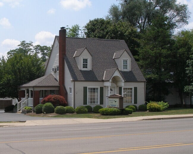
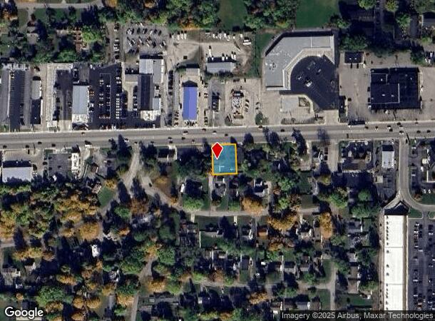
Property Record
3215 E Main St, Richmond, IN 47374
NEARBY LISTINGS FOR SALE OR LEASE
Property Detail
3215 E Main St
Richmond, IN
Ravinia Park First Addition In The City
89-16-34-430-504.001-030
Wayne
Sfr
Indiana
X
0.29 AC
39135C0125E
Indiana South Area
2,606 SF
Other Market Areas
DEMOGRAPHICS near 3215 E Main St
1 Mile
3 Mile
5 Mile
2024 Total Population
5,280
33,747
44,851
2029 Population
5,240
33,953
45,017
Pop Growth 2024-2029
(0.76%)
+ 0.61%
+ 0.37%
Average Age
44
40
41
2024 Total Households
2,342
14,194
18,906
HH Growth 2024-2029
(0.98%)
+ 0.58%
+ 0.33%
Median Household Inc
$54,952
$43,309
$44,768
Avg Household Size
2.10
2.20
2.20
2024 Avg HH Vehicles
2.00
2.00
2.00
Median Home Value
$155,804
$108,492
$110,786
Median Year Built
1970
1957
1959
Nearby Places
Map Layers
Map Styles
 Street
 Aerial
- Restaurants
- Banks
- Shops
- Fitness
- Groceries
PUBLIC TRANSPORTATION
AIRPORT
James M Cox Dayton International
DRIVE
WALK
Distance
James M Cox Dayton International
47 min
38.1 mi
SALE & LEASE HISTORY
LISTING DATE
SALE/LEASE

Aug 26, 2021
For Sale
Nearby Properties
Address
Land Use
TOTAL SIZE
Lot Size
Zoning
Address
Land Use
TOTAL SIZE
Lot Size
Zoning
171,768 SF
72.69 AC
ZO01
Address
Land Use
TOTAL SIZE
Lot Size
Zoning
1,744 SF
73.12 AC
Address
Land Use
TOTAL SIZE
Lot Size
Zoning
9,708 SF
9.11 AC
ZO01
Address
Land Use
TOTAL SIZE
Lot Size
Zoning
84,892 SF
24.43 AC
ZO01
Address
Land Use
TOTAL SIZE
Lot Size
Zoning
126,136 SF
28.16 AC
Address
Land Use
TOTAL SIZE
Lot Size
Zoning
162,366 SF
15 AC
ZO01
Address
Land Use
TOTAL SIZE
Lot Size
Zoning
137,081 SF
13.39 AC
ZO01
Address
Land Use
TOTAL SIZE
Lot Size
Zoning
67,550 SF
5.83 AC
ZO01
Address
Land Use
TOTAL SIZE
Lot Size
Zoning
21,048 SF
14.95 AC
ZO01
Address
Land Use
TOTAL SIZE
Lot Size
Zoning
60,680 SF
2.04 AC
ZO01
Address
Land Use
TOTAL SIZE
Lot Size
Zoning
207,981 SF
ZO01
Address
Land Use
TOTAL SIZE
Lot Size
Zoning
114,080 SF
0.78 AC
ZO01
Address
Land Use
TOTAL SIZE
Lot Size
Zoning
13,510 SF
10.75 AC
ZO01
Address
Land Use
TOTAL SIZE
Lot Size
Zoning
77,255 SF
7.52 AC
ZO01
Address
Land Use
TOTAL SIZE
Lot Size
Zoning
62,865 SF
2.25 AC
ZO01
Address
Land Use
TOTAL SIZE
Lot Size
Zoning
8,877 SF
66.35 AC
ZO01
Address
Land Use
TOTAL SIZE
Lot Size
Zoning
214,030 SF
20 AC
ZO01
Address
Land Use
TOTAL SIZE
Lot Size
Zoning
504,175 SF
25.07 AC
Address
Land Use
TOTAL SIZE
Lot Size
Zoning
6,144 SF
6.16 AC
ZO01
Address
Land Use
TOTAL SIZE
Lot Size
Zoning
2,780 SF
13.18 AC
ZO01
Address
Land Use
TOTAL SIZE
Lot Size
Zoning
59,648 SF
1.55 AC
Address
Land Use
TOTAL SIZE
Lot Size
Zoning
49,444 SF
7.27 AC
ZO01
Address
Land Use
TOTAL SIZE
Lot Size
Zoning
85,270 SF
8.26 AC
ZO01
Address
Land Use
TOTAL SIZE
Lot Size
Zoning
91,286 SF
6.47 AC
ZO01
Address
Land Use
TOTAL SIZE
Lot Size
Zoning
72,710 SF
6.77 AC
ZO01
Address
Land Use
TOTAL SIZE
Lot Size
Zoning
70,720 SF
1.75 AC
ZO01
Address
Land Use
TOTAL SIZE
Lot Size
Zoning
25,462 SF
3.22 AC
ZO01
Address
Land Use
TOTAL SIZE
Lot Size
Zoning
106,990 SF
9.99 AC
ZO01
Address
Land Use
TOTAL SIZE
Lot Size
Zoning
38,589 SF
1.87 AC
ZO01
Address
Land Use
TOTAL SIZE
Lot Size
Zoning
54,358 SF
4.04 AC
ZO01
The World's #1 Commercial Real Estate Marketplace
Connect with us
© 2025 CoStar Group
The information above has been obtained from sources believed reliable. While we do not doubt its accuracy we have not verified it and make no guarantee, warranty or representation about it. It is your responsibility to independently confirm its accuracy and completeness. Any projections, opinions, assumptions, or estimates used are for example only and do not represent the current or future performance of the property. The value of this transaction to you depends on tax and other factors which should be evaluated by your tax, financial, and legal advisors. You and your advisors should conduct a careful, independent investigation of the property to determine to your satisfaction the suitability of the property for your needs.