Property Record
3215 Powder Mill Rd, Hyattsville, MD 20783
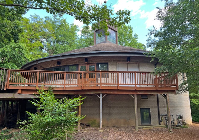

Property Detail
3215 Powder Mill Rd
01-0049619
CHURCH WOMENS CTR CENTER (DEL/COMB FOR EXEMPTION 7/1/11)
Religious
Prince Georges
RR
Maryland
B and X Area of moderate flood hazard, usually the area between the limits of the 100-year and 500-year floods.
14
2024
4.93 AC
2025
Beltsville/Calverton
807409
Washington, DC
11,509 SF
Washington-Arlington-Alexandria, DC-VA-MD-WV
NEARBY LISTINGS FOR SALE OR LEASE
DEMOGRAPHICS near 3215 Powder Mill Rd
1 mile
3 mile
5 mile
2025 Total Population
9,853
124,235
355,554
2030 Population
9,801
126,057
362,338
Pop Growth 2025-2030
(0.53%)
+ 1.47%
+ 1.91%
Average Age
41
38
38
2025 Total Households
3,342
40,391
120,873
HH Growth 2025-2030
(1.26%)
+ 1.48%
+ 2.02%
Median Household Inc
$85,613
$91,356
$96,838
Avg Household Size
2.80
2.80
2.80
2025 Avg HH Vehicles
2.00
2.00
2.00
Median Home Value
$372,681
$470,336
$521,489
Median Year Built
1981
1974
1968
Nearby Places
Map Layers
Map Styles
 Street
 Aerial
Layers
 Traffic
 Biking
Places
Listings with unknown addresses are not visible on the map
- Restaurants
- Banks
- Shops
- Fitness
- Groceries
PUBLIC TRANSPORTATION
COMMUTER RAIL
Drive
Walk
Distance
8 min
3.9 mi
Drive
Walk
Distance
8 min
3.9 mi
AIRPORT
Ronald Reagan Washington Ntl
Drive
Walk
Distance
Ronald Reagan Washington Ntl
34 min
16.6 mi
Baltimore/Washington International Thurgood Marshall
Drive
Walk
Distance
Baltimore/Washington International Thurgood Marshall
33 min
24.6 mi
Washington Dulles International
Drive
Walk
Distance
Washington Dulles International
51 min
33.9 mi
Freight Ports
Port of Baltimore
Drive
Walk
Distance
Port of Baltimore
36 min
27.3 mi
SALE & LEASE HISTORY
LISTING DATE
SALE/LEASE

Jun 01, 2023
For Sale
Nearby Properties
Address
Land Use
TOTAL SIZE
Lot Size
Zoning
Address
Land Use
TOTAL SIZE
Lot Size
Zoning
13.01 AC
RR
Address
Land Use
TOTAL SIZE
Lot Size
Zoning
456,429 SF
35.07 AC
I3
Address
Land Use
TOTAL SIZE
Lot Size
Zoning
610.61 AC
RE2
Address
Land Use
TOTAL SIZE
Lot Size
Zoning
1,244,733 SF
38.03 AC
RE2
Address
Land Use
TOTAL SIZE
Lot Size
Zoning
639,347 SF
2.28 AC
RTOLE
Address
Land Use
TOTAL SIZE
Lot Size
Zoning
917,092 SF
17.19 AC
R10
Address
Land Use
TOTAL SIZE
Lot Size
Zoning
3.53 AC
RTOLE
Address
Land Use
TOTAL SIZE
Lot Size
Zoning
1,146,407 SF
60.25 AC
AG
Address
Land Use
TOTAL SIZE
Lot Size
Zoning
2.05 AC
RTOLE
Address
Land Use
TOTAL SIZE
Lot Size
Zoning
66,150 SF
6.79 AC
CRF
Address
Land Use
TOTAL SIZE
Lot Size
Zoning
508 SF
7.27 AC
LTOE
Address
Land Use
TOTAL SIZE
Lot Size
Zoning
0.79 AC
RTOLE
Address
Land Use
TOTAL SIZE
Lot Size
Zoning
330,555 SF
2.12 AC
NAC
Address
Land Use
TOTAL SIZE
Lot Size
Zoning
458,546 SF
8.56 AC
R10
Address
Land Use
TOTAL SIZE
Lot Size
Zoning
385,000 SF
16.42 AC
RH
Address
Land Use
TOTAL SIZE
Lot Size
Zoning
569,794 SF
5.70 AC
RMF48
Address
Land Use
TOTAL SIZE
Lot Size
Zoning
43,382 SF
2.18 AC
Address
Land Use
TOTAL SIZE
Lot Size
Zoning
371,939 SF
21.54 AC
EOF1.
Address
Land Use
TOTAL SIZE
Lot Size
Zoning
256,662 SF
3.69 AC
LTOE
Address
Land Use
TOTAL SIZE
Lot Size
Zoning
285,116 SF
14.62 AC
AG
Address
Land Use
TOTAL SIZE
Lot Size
Zoning
15.11 AC
RMF20
Address
Land Use
TOTAL SIZE
Lot Size
Zoning
296,100 SF
12.08 AC
R20
Address
Land Use
TOTAL SIZE
Lot Size
Zoning
39.59 AC
ROS
Address
Land Use
TOTAL SIZE
Lot Size
Zoning
30,426 SF
12.96 AC
NAC
Address
Land Use
TOTAL SIZE
Lot Size
Zoning
170,619 SF
11.49 AC
R20
Address
Land Use
TOTAL SIZE
Lot Size
Zoning
598,096 SF
24.36 AC
NAC
Address
Land Use
TOTAL SIZE
Lot Size
Zoning
545,265 SF
9.51 AC
R10
Address
Land Use
TOTAL SIZE
Lot Size
Zoning
16.09 AC
RMF20
Address
Land Use
TOTAL SIZE
Lot Size
Zoning
394,180 SF
9.62 AC
LTOE
Address
Land Use
TOTAL SIZE
Lot Size
Zoning
170,815 SF
40.64 AC
RR
The World's #1 Commercial Real Estate Marketplace
Connect with us
© 2026 CoStar Group
The information above has been obtained from sources believed reliable. While we do not doubt its accuracy we have not verified it and make no guarantee, warranty or representation about it. It is your responsibility to independently confirm its accuracy and completeness. Any projections, opinions, assumptions, or estimates used are for example only and do not represent the current or future performance of the property. The value of this transaction to you depends on tax and other factors which should be evaluated by your tax, financial, and legal advisors. You and your advisors should conduct a careful, independent investigation of the property to determine to your satisfaction the suitability of the property for your needs.