Property Record
3216 137Th St, Flushing, NY 11354
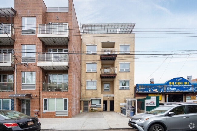
This Property Is For Sale
Current Lease Availabilities
NEARBY LISTINGS FOR SALE OR LEASE
Property Detail
3216 137Th St
Condominium
Queens
X
New York
3604970114F
1109
2024
Downtown Flushing
2025
Long Island (New York)
088902
New York-Jersey City-White Plains, NY-NJ
1,819 SF
04952-1109
DEMOGRAPHICS near 3216 137Th St
1 mile
3 mile
5 mile
2024 Total Population
110,525
594,216
1,542,816
2029 Population
106,235
555,092
1,443,017
Pop Growth 2024-2029
(3.88%)
(6.58%)
(6.47%)
Average Age
45
42
41
2024 Total Households
40,389
200,837
549,404
HH Growth 2024-2029
(4.18%)
(6.69%)
(6.68%)
Median Household Inc
$46,931
$63,503
$68,669
Avg Household Size
2.60
2.80
2.70
2024 Avg HH Vehicles
1.00
1.00
1.00
Median Home Value
$508,405
$676,652
$688,281
Median Year Built
1962
1956
1954
Nearby Places
Map Layers
Map Styles
 Street
 Aerial
Transit
 Traffic
 Biking
Places
Listings with unknown addresses are not visible on the map
- Restaurants
- Banks
- Shops
- Fitness
- Groceries
PUBLIC TRANSPORTATION
TRANSIT/SUBWAY
Flushing-Main Street (7 - New York MTA Subway (The Subway))
Drive
Walk
Distance
Flushing-Main Street (7 - New York MTA Subway (The Subway))
2 min
12 min
0.7 mi
COMMUTER RAIL
Flushing-Main Street Station (Port Washington Branch - Long Island Rail Road)
Drive
Walk
Distance
Flushing-Main Street Station (Port Washington Branch - Long Island Rail Road)
3 min
16 min
0.8 mi
Murray Hill Station (Port Washington Branch - Long Island Rail Road)
Drive
Walk
Distance
Murray Hill Station (Port Washington Branch - Long Island Rail Road)
3 min
1.5 mi
AIRPORT
LaGuardia
Drive
Walk
Distance
LaGuardia
8 min
3.7 mi
John F Kennedy International
Drive
Walk
Distance
John F Kennedy International
15 min
11.2 mi
Newark Liberty International
Drive
Walk
Distance
Newark Liberty International
38 min
30.4 mi
Freight Ports
NY - Red Hook Container Terminal
Drive
Walk
Distance
NY - Red Hook Container Terminal
23 min
14.2 mi
Nearby Properties
Address
Land Use
TOTAL SIZE
Lot Size
Zoning
Address
Land Use
TOTAL SIZE
Lot Size
Zoning
2,078,606 SF
58.93 AC
R4
Address
Land Use
TOTAL SIZE
Lot Size
Zoning
1,258,350 SF
410.24 AC
PARK
Address
Land Use
TOTAL SIZE
Lot Size
Zoning
1,292,074 SF
C4-2F
Address
Land Use
TOTAL SIZE
Lot Size
Zoning
234,891 SF
3.17 AC
C4-5X
Address
Land Use
TOTAL SIZE
Lot Size
Zoning
8.28 AC
R7-1
Address
Land Use
TOTAL SIZE
Lot Size
Zoning
8.28 AC
R7-1
Address
Land Use
TOTAL SIZE
Lot Size
Zoning
8.28 AC
R7-1
Address
Land Use
TOTAL SIZE
Lot Size
Zoning
15,000 SF
255.27 AC
PARK
Address
Land Use
TOTAL SIZE
Lot Size
Zoning
4,050 SF
113.40 AC
PARK
Address
Land Use
TOTAL SIZE
Lot Size
Zoning
4,800 SF
80.10 AC
PARK
Address
Land Use
TOTAL SIZE
Lot Size
Zoning
332,266 SF
12.57 AC
M2-1
Address
Land Use
TOTAL SIZE
Lot Size
Zoning
749,142 SF
16.48 AC
R6
Address
Land Use
TOTAL SIZE
Lot Size
Zoning
749,142 SF
16.48 AC
R6
Address
Land Use
TOTAL SIZE
Lot Size
Zoning
749,142 SF
16.48 AC
R6
Address
Land Use
TOTAL SIZE
Lot Size
Zoning
749,142 SF
16.48 AC
R6
Address
Land Use
TOTAL SIZE
Lot Size
Zoning
749,142 SF
16.48 AC
R6
Address
Land Use
TOTAL SIZE
Lot Size
Zoning
749,142 SF
16.48 AC
R6
Address
Land Use
TOTAL SIZE
Lot Size
Zoning
749,142 SF
16.48 AC
R6
Address
Land Use
TOTAL SIZE
Lot Size
Zoning
577,654 SF
5.38 AC
R6
Address
Land Use
TOTAL SIZE
Lot Size
Zoning
521,944 SF
16.68 AC
R4
Address
Land Use
TOTAL SIZE
Lot Size
Zoning
360,000 SF
5.88 AC
C4-2
Address
Land Use
TOTAL SIZE
Lot Size
Zoning
1,389,532 SF
31.54 AC
R6
Address
Land Use
TOTAL SIZE
Lot Size
Zoning
489,440 SF
12.69 AC
R5
Address
Land Use
TOTAL SIZE
Lot Size
Zoning
489,440 SF
12.69 AC
R5
Address
Land Use
TOTAL SIZE
Lot Size
Zoning
489,440 SF
12.69 AC
R5
Address
Land Use
TOTAL SIZE
Lot Size
Zoning
489,440 SF
12.69 AC
R5
Address
Land Use
TOTAL SIZE
Lot Size
Zoning
489,440 SF
12.69 AC
R5
Address
Land Use
TOTAL SIZE
Lot Size
Zoning
489,440 SF
12.69 AC
R5
Address
Land Use
TOTAL SIZE
Lot Size
Zoning
489,440 SF
12.69 AC
R5
Address
Land Use
TOTAL SIZE
Lot Size
Zoning
489,440 SF
12.69 AC
R5
The World's #1 Commercial Real Estate Marketplace
Connect with us
© 2026 CoStar Group
The information above has been obtained from sources believed reliable. While we do not doubt its accuracy we have not verified it and make no guarantee, warranty or representation about it. It is your responsibility to independently confirm its accuracy and completeness. Any projections, opinions, assumptions, or estimates used are for example only and do not represent the current or future performance of the property. The value of this transaction to you depends on tax and other factors which should be evaluated by your tax, financial, and legal advisors. You and your advisors should conduct a careful, independent investigation of the property to determine to your satisfaction the suitability of the property for your needs.