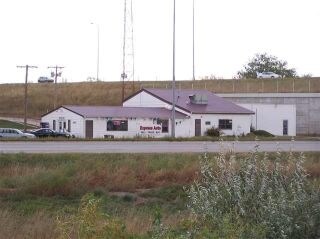
Property Record
3216 E Highway 44, Rapid City, SD 57703

Save to a Folder
{{folder.Name}}
{{folder.ListingIds.length}} Properties
{{folder.ListingIds.length}} Property
Create a New Folder
Property Detail
3216 E Highway 44
Rapid City, SD
HOLIDAY SUBD, LOT 1
3809128015
PENNINGTON
Conveniencestore
South Dakota
B and X Area of moderate flood hazard, usually the area between the limits of the 100-year and 500-year floods.
1
2025
2.20 AC
2025
Rapid City
010906
Other Market Areas
5,512 SF
NEARBY LISTINGS FOR SALE OR LEASE
DEMOGRAPHICS near 3216 E Highway 44
1 mile
3 mile
5 mile
2025 Total Population
4,339
36,865
68,934
2030 Population
4,622
38,706
72,066
Pop Growth 2025-2030
+ 6.52%
+ 4.99%
+ 4.54%
Average Age
39
39
40
2025 Total Households
1,745
14,917
28,105
HH Growth 2025-2030
+ 6.76%
+ 5.27%
+ 4.78%
Median Household Inc
$86,910
$72,068
$69,018
Avg Household Size
2.40
2.30
2.30
2025 Avg HH Vehicles
2.00
2.00
2.00
Median Home Value
$310,294
$267,089
$278,499
Median Year Built
2002
1989
1985
Nearby Places
Map Layers
Map Styles
 Street
 Aerial
Layers
 Traffic
 Biking
Places
Listings with unknown addresses are not visible on the map
- Restaurants
- Banks
- Shops
- Fitness
- Groceries
PUBLIC TRANSPORTATION
AIRPORT
Rapid City Regional
Drive
Walk
Distance
Rapid City Regional
12 min
7.0 mi
Freight Ports
Tulsa Port Of Catoosa
Drive
Walk
Distance
Tulsa Port Of Catoosa
966 min
888.1 mi
Nearby Properties
Address
Land Use
TOTAL SIZE
Lot Size
Zoning
Address
Land Use
TOTAL SIZE
Lot Size
Zoning
19,781 SF
11.03 AC
Address
Land Use
TOTAL SIZE
Lot Size
Zoning
4,748 SF
9.94 AC
Address
Land Use
TOTAL SIZE
Lot Size
Zoning
6,480 SF
11.58 AC
Address
Land Use
TOTAL SIZE
Lot Size
Zoning
5,448 SF
8 AC
Address
Land Use
TOTAL SIZE
Lot Size
Zoning
2,632 SF
8.11 AC
Address
Land Use
TOTAL SIZE
Lot Size
Zoning
14,484 SF
5.20 AC
Address
Land Use
TOTAL SIZE
Lot Size
Zoning
55,442 SF
23.96 AC
Address
Land Use
TOTAL SIZE
Lot Size
Zoning
4,005 SF
12.09 AC
Address
Land Use
TOTAL SIZE
Lot Size
Zoning
38,030 SF
13.47 AC
Address
Land Use
TOTAL SIZE
Lot Size
Zoning
2,018 SF
5.66 AC
Address
Land Use
TOTAL SIZE
Lot Size
Zoning
46,644 SF
11.89 AC
Address
Land Use
TOTAL SIZE
Lot Size
Zoning
2,865 SF
7.08 AC
Address
Land Use
TOTAL SIZE
Lot Size
Zoning
29,226 SF
1.38 AC
Address
Land Use
TOTAL SIZE
Lot Size
Zoning
28,584 SF
5.62 AC
Address
Land Use
TOTAL SIZE
Lot Size
Zoning
28,894 SF
2.17 AC
Address
Land Use
TOTAL SIZE
Lot Size
Zoning
714 SF
11.14 AC
Address
Land Use
TOTAL SIZE
Lot Size
Zoning
29,196 SF
3.89 AC
Address
Land Use
TOTAL SIZE
Lot Size
Zoning
147,325 SF
11.93 AC
Address
Land Use
TOTAL SIZE
Lot Size
Zoning
162,960 SF
22.56 AC
Address
Land Use
TOTAL SIZE
Lot Size
Zoning
227,112 SF
21.01 AC
Address
Land Use
TOTAL SIZE
Lot Size
Zoning
17,392 SF
7.85 AC
Address
Land Use
TOTAL SIZE
Lot Size
Zoning
45,485 SF
9.84 AC
Address
Land Use
TOTAL SIZE
Lot Size
Zoning
21,735 SF
11.60 AC
Address
Land Use
TOTAL SIZE
Lot Size
Zoning
27,300 SF
70.55 AC
Address
Land Use
TOTAL SIZE
Lot Size
Zoning
2,018 SF
3.73 AC
Address
Land Use
TOTAL SIZE
Lot Size
Zoning
24,297 SF
5.15 AC
Address
Land Use
TOTAL SIZE
Lot Size
Zoning
2,058 SF
3.60 AC
Address
Land Use
TOTAL SIZE
Lot Size
Zoning
65,922 SF
6 AC
Address
Land Use
TOTAL SIZE
Lot Size
Zoning
55,000 SF
10.62 AC
The World's #1 Commercial Real Estate Marketplace
Connect with us
© 2026 CoStar Group
The information above has been obtained from sources believed reliable. While we do not doubt its accuracy we have not verified it and make no guarantee, warranty or representation about it. It is your responsibility to independently confirm its accuracy and completeness. Any projections, opinions, assumptions, or estimates used are for example only and do not represent the current or future performance of the property. The value of this transaction to you depends on tax and other factors which should be evaluated by your tax, financial, and legal advisors. You and your advisors should conduct a careful, independent investigation of the property to determine to your satisfaction the suitability of the property for your needs.