Property Record
3217 Commander Shepard Blvd, Hampton, VA 23666
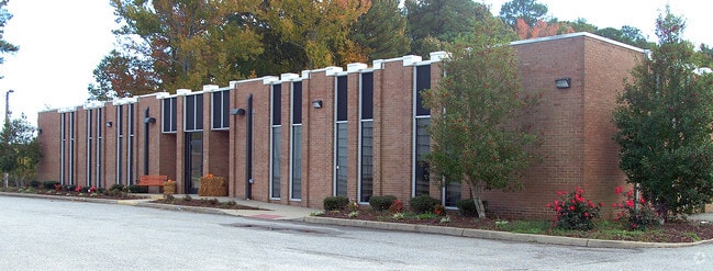


This Property Is For Sale
Current Lease Availabilities
Property Detail
3217 Commander Shepard Blvd
6000976
CDR SHEPPARD LLC LND PC5A. 2.1919 AC - FKA 3217 COMMDR SHEPRD BLVD.PTPC5.PTPC4. 4.6063
Scientificpharmaceuticalmedicalresearchfacility
Hampton City
49 LBP - L
Virginia
B and X Area of moderate flood hazard, usually the area between the limits of the 100-year and 500-year floods.
2.19 AC
2025
Copeland
2025
Hampton Roads
010314
Virginia Beach-Chesapeake-Norfolk, VA-NC
28,425 SF
NEARBY LISTINGS FOR SALE OR LEASE
DEMOGRAPHICS near 3217 Commander Shepard Blvd
1 mile
3 mile
5 mile
2024 Total Population
4,417
47,065
151,977
2029 Population
4,495
47,608
151,646
Pop Growth 2024-2029
+ 1.77%
+ 1.15%
(0.22%)
Average Age
35
36
39
2024 Total Households
1,901
18,469
62,045
HH Growth 2024-2029
+ 1.37%
+ 0.94%
(0.36%)
Median Household Inc
$72,701
$83,598
$79,434
Avg Household Size
2.30
2.50
2.40
2024 Avg HH Vehicles
2.00
2.00
2.00
Median Home Value
$322,026
$340,452
$294,225
Median Year Built
1995
1989
1982
Nearby Places
Map Layers
Map Styles
 Street
 Aerial
Transit
 Traffic
 Biking
Places
Listings with unknown addresses are not visible on the map
- Restaurants
- Banks
- Shops
- Fitness
- Groceries
PUBLIC TRANSPORTATION
AIRPORT
Newport News/Williamsburg International
Drive
Walk
Distance
Newport News/Williamsburg International
17 min
9.3 mi
Norfolk International
Drive
Walk
Distance
Norfolk International
35 min
21.6 mi
Freight Ports
Virginia Port Authority - Newport News
Drive
Walk
Distance
Virginia Port Authority - Newport News
16 min
11.0 mi
Nearby Properties
Address
Land Use
TOTAL SIZE
Lot Size
Zoning
Address
Land Use
TOTAL SIZE
Lot Size
Zoning
1 SF
764 AC
5 R-13 ONE
Address
Land Use
TOTAL SIZE
Lot Size
Zoning
2,500 SF
2,882 AC
5 R-13 ONE
Address
Land Use
TOTAL SIZE
Lot Size
Zoning
249,628 SF
52.71 AC
14 C-2 LIM
Address
Land Use
TOTAL SIZE
Lot Size
Zoning
35,550 SF
23.07 AC
14 C-2 LIM
Address
Land Use
TOTAL SIZE
Lot Size
Zoning
22,531 SF
41.78 AC
36 MD-3 MU
Address
Land Use
TOTAL SIZE
Lot Size
Zoning
350,468 SF
7.97 AC
11 MD-4 MU
Address
Land Use
TOTAL SIZE
Lot Size
Zoning
19,328 SF
15.14 AC
14 C-2 LIM
Address
Land Use
TOTAL SIZE
Lot Size
Zoning
107,790 SF
5.66 AC
31 HRC-1 H
Address
Land Use
TOTAL SIZE
Lot Size
Zoning
248,956 SF
12.80 AC
14 C-2 LIM
Address
Land Use
TOTAL SIZE
Lot Size
Zoning
2,095 SF
23.19 AC
MULTI-FAMI
Address
Land Use
TOTAL SIZE
Lot Size
Zoning
5,389 SF
24.08 AC
RMF,LB
Address
Land Use
TOTAL SIZE
Lot Size
Zoning
7,720 SF
9.91 AC
14 C-2 LIM
Address
Land Use
TOTAL SIZE
Lot Size
Zoning
14,844 SF
12.93 AC
33 HRC-2 H
Address
Land Use
TOTAL SIZE
Lot Size
Zoning
286,173 SF
10 AC
14 C-2 LIM
Address
Land Use
TOTAL SIZE
Lot Size
Zoning
15,606 SF
12.07 AC
14 C-2 LIM
Address
Land Use
TOTAL SIZE
Lot Size
Zoning
22,000 SF
20 AC
33 HRC-2 H
Address
Land Use
TOTAL SIZE
Lot Size
Zoning
4,037 SF
6.72 AC
PUDM
Address
Land Use
TOTAL SIZE
Lot Size
Zoning
185,919 SF
16.67 AC
13 C-1 NEI
Address
Land Use
TOTAL SIZE
Lot Size
Zoning
46.94 AC
39 LFA-4 L
Address
Land Use
TOTAL SIZE
Lot Size
Zoning
202 SF
18.37 AC
PLANNED DE
Address
Land Use
TOTAL SIZE
Lot Size
Zoning
7,840 SF
19.66 AC
9 R-M MULT
Address
Land Use
TOTAL SIZE
Lot Size
Zoning
212,766 SF
9.54 AC
13 C-1 NEI
Address
Land Use
TOTAL SIZE
Lot Size
Zoning
71,677 SF
18.59 AC
14 C-2 LIM
Address
Land Use
TOTAL SIZE
Lot Size
Zoning
403,136 SF
37.03 AC
31 HRC-1 H
Address
Land Use
TOTAL SIZE
Lot Size
Zoning
29,076 SF
11.28 AC
14 C-2 LIM
Address
Land Use
TOTAL SIZE
Lot Size
Zoning
198,480 SF
22.07 AC
49 LBP - L
Address
Land Use
TOTAL SIZE
Lot Size
Zoning
233,296 SF
11.83 AC
14 C-2 LIM
Address
Land Use
TOTAL SIZE
Lot Size
Zoning
19,362 SF
13.45 AC
13 C-1 NEI
Address
Land Use
TOTAL SIZE
Lot Size
Zoning
123,459 SF
29.58 AC
13 C-1 NEI
Address
Land Use
TOTAL SIZE
Lot Size
Zoning
84,044 SF
13.49 AC
31 HRC-1 H
The World's #1 Commercial Real Estate Marketplace
Connect with us
© 2026 CoStar Group
The information above has been obtained from sources believed reliable. While we do not doubt its accuracy we have not verified it and make no guarantee, warranty or representation about it. It is your responsibility to independently confirm its accuracy and completeness. Any projections, opinions, assumptions, or estimates used are for example only and do not represent the current or future performance of the property. The value of this transaction to you depends on tax and other factors which should be evaluated by your tax, financial, and legal advisors. You and your advisors should conduct a careful, independent investigation of the property to determine to your satisfaction the suitability of the property for your needs.