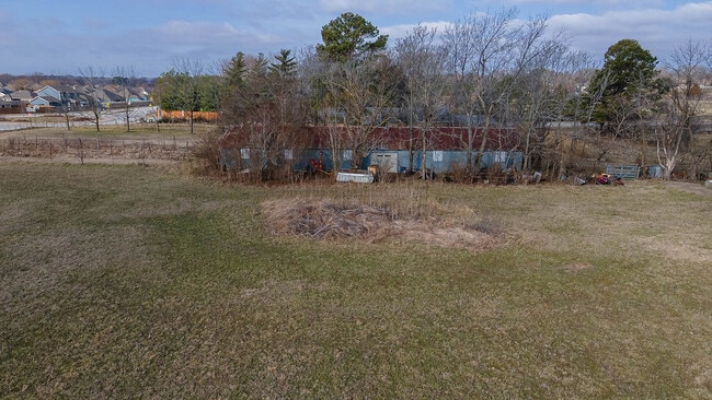
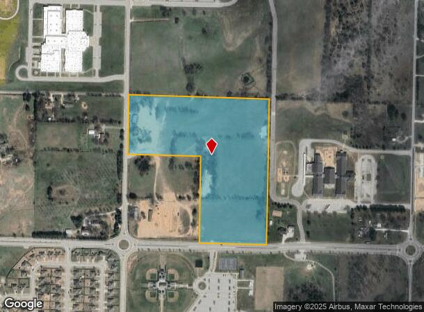
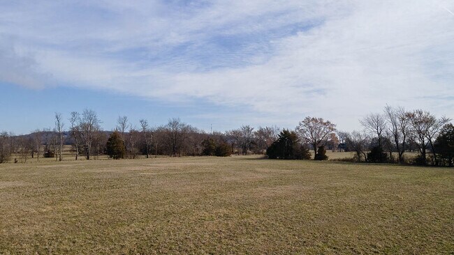
Property Record
3217 Hylton Rd, Springdale, AR 72764
NEARBY LISTINGS FOR SALE OR LEASE
Property Detail
3217 Hylton Rd
815-36192-400
Springdale Outlots
Publicschool
ANNEXED TO CITY OF SPRINGDALE FOR 2006 & FOLLOWING YEARS PER ISLAND ANNEXATION ORDINANCE NO. 3894 SW SW 40.00 AC
X
Washington
05143C0090G
Arkansas
0
40 AC
2025
Outlying Washington Cnty
010109
Fayetteville/Springdale/Rogers
985 SF
Fayetteville-Springdale-Rogers, AR-MO
DEMOGRAPHICS near 3217 Hylton Rd
1 Mile
3 Mile
5 Mile
2024 Total Population
2,514
35,370
89,547
2029 Population
2,792
38,954
98,188
Pop Growth 2024-2029
+ 11.06%
+ 10.13%
+ 9.65%
Average Age
38
33
35
2024 Total Households
871
11,041
30,438
HH Growth 2024-2029
+ 11.48%
+ 10.32%
+ 9.78%
Median Household Inc
$103,446
$63,224
$64,642
Avg Household Size
2.80
3.10
2.80
2024 Avg HH Vehicles
2.00
2.00
2.00
Median Home Value
$258,507
$229,773
$233,107
Median Year Built
2005
1997
1993
Nearby Places
Map Layers
Map Styles
 Street
 Aerial
- Restaurants
- Banks
- Shops
- Fitness
- Groceries
PUBLIC TRANSPORTATION
AIRPORT
Northwest Arkansas Ntl
DRIVE
WALK
Distance
Northwest Arkansas Ntl
42 min
19.6 mi
SALE & LEASE HISTORY
LISTING DATE
SALE/LEASE

Apr 03, 2023
For Sale
Nearby Properties
Address
Land Use
TOTAL SIZE
Lot Size
Zoning
Address
Land Use
TOTAL SIZE
Lot Size
Zoning
481,800 SF
40 AC
Address
Land Use
TOTAL SIZE
Lot Size
Zoning
4,941 SF
10.87 AC
Address
Land Use
TOTAL SIZE
Lot Size
Zoning
156,072 SF
12.43 AC
Address
Land Use
TOTAL SIZE
Lot Size
Zoning
178,140 SF
4.39 AC
Address
Land Use
TOTAL SIZE
Lot Size
Zoning
117,196 SF
9.74 AC
Address
Land Use
TOTAL SIZE
Lot Size
Zoning
73,436 SF
16.01 AC
I1
Address
Land Use
TOTAL SIZE
Lot Size
Zoning
69,412 SF
8.81 AC
R0
Address
Land Use
TOTAL SIZE
Lot Size
Zoning
116,736 SF
10.95 AC
Address
Land Use
TOTAL SIZE
Lot Size
Zoning
74,434 SF
32.25 AC
Address
Land Use
TOTAL SIZE
Lot Size
Zoning
352,195 SF
15 AC
Address
Land Use
TOTAL SIZE
Lot Size
Zoning
107,950 SF
6.68 AC
C2
Address
Land Use
TOTAL SIZE
Lot Size
Zoning
38,594 SF
6.04 AC
Address
Land Use
TOTAL SIZE
Lot Size
Zoning
69,102 SF
4.23 AC
C1
Address
Land Use
TOTAL SIZE
Lot Size
Zoning
27,760 SF
6.09 AC
Address
Land Use
TOTAL SIZE
Lot Size
Zoning
104,176 SF
8.88 AC
R0
Address
Land Use
TOTAL SIZE
Lot Size
Zoning
162,000 SF
16 AC
I2
Address
Land Use
TOTAL SIZE
Lot Size
Zoning
38,058 SF
9.13 AC
Address
Land Use
TOTAL SIZE
Lot Size
Zoning
102,190 SF
14 AC
I2
Address
Land Use
TOTAL SIZE
Lot Size
Zoning
50,154 SF
4.09 AC
C2
Address
Land Use
TOTAL SIZE
Lot Size
Zoning
81,600 SF
6.98 AC
Address
Land Use
TOTAL SIZE
Lot Size
Zoning
59,760 SF
1.77 AC
Address
Land Use
TOTAL SIZE
Lot Size
Zoning
16,800 SF
6.26 AC
Address
Land Use
TOTAL SIZE
Lot Size
Zoning
34,303 SF
1.56 AC
C1
Address
Land Use
TOTAL SIZE
Lot Size
Zoning
118,220 SF
3.27 AC
I1
Address
Land Use
TOTAL SIZE
Lot Size
Zoning
55,900 SF
3.42 AC
C2
Address
Land Use
TOTAL SIZE
Lot Size
Zoning
79,453 SF
7.04 AC
Address
Land Use
TOTAL SIZE
Lot Size
Zoning
39,916 SF
5.24 AC
Address
Land Use
TOTAL SIZE
Lot Size
Zoning
32,705 SF
5.66 AC
Address
Land Use
TOTAL SIZE
Lot Size
Zoning
54,551 SF
6.48 AC
R2
Address
Land Use
TOTAL SIZE
Lot Size
Zoning
32,032 SF
1.66 AC
C2
The World's #1 Commercial Real Estate Marketplace
Connect with us
© 2026 CoStar Group
The information above has been obtained from sources believed reliable. While we do not doubt its accuracy we have not verified it and make no guarantee, warranty or representation about it. It is your responsibility to independently confirm its accuracy and completeness. Any projections, opinions, assumptions, or estimates used are for example only and do not represent the current or future performance of the property. The value of this transaction to you depends on tax and other factors which should be evaluated by your tax, financial, and legal advisors. You and your advisors should conduct a careful, independent investigation of the property to determine to your satisfaction the suitability of the property for your needs.