Property Record
3218 S 79Th Ave E, Tulsa, OK 74145


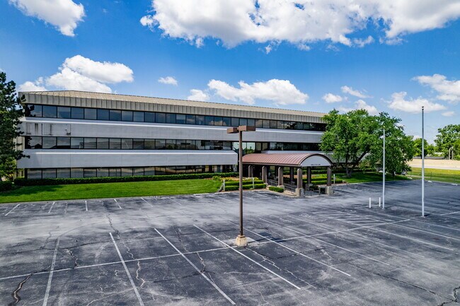
Property Detail
3218 S 79Th Ave E
20125-93-23-00980
PRT LT 3 INTERCHANGE PL & PRT LT 3 BEG 1463.24W & 915.74S NEC SEC TH SE261.9 SW311.23 CRV LF87.54 NW291.93 NE244 NELY101.98 NE54 POB & BEG 1364.39W & 831.72S NEC SEC TH SE261.9 SW130 NW261.9 NE130 POB
Medicalbuilding
TULSA
CS
Oklahoma
B and X Area of moderate flood hazard, usually the area between the limits of the 100-year and 500-year floods.
3
2025
3.13 AC
2025
North Central
006905
Tulsa
55,510 SF
Tulsa, OK
NEARBY LISTINGS FOR SALE OR LEASE
DEMOGRAPHICS near 3218 S 79Th Ave E
1 mile
3 mile
5 mile
2025 Total Population
8,218
98,487
258,331
2030 Population
8,447
101,404
266,461
Pop Growth 2025-2030
+ 2.79%
+ 2.96%
+ 3.15%
Average Age
40
38
38
2025 Total Households
3,572
41,950
108,793
HH Growth 2025-2030
+ 2.97%
+ 3.12%
+ 3.28%
Median Household Inc
$52,490
$53,677
$57,958
Avg Household Size
2.20
2.30
2.30
2025 Avg HH Vehicles
2.00
2.00
2.00
Median Home Value
$162,846
$178,472
$205,871
Median Year Built
1966
1967
1971
Nearby Places
Map Layers
Map Styles
 Street
 Aerial
Transit
 Traffic
 Biking
Places
Listings with unknown addresses are not visible on the map
- Restaurants
- Banks
- Shops
- Fitness
- Groceries
PUBLIC TRANSPORTATION
AIRPORT
Tulsa International
Drive
Walk
Distance
Tulsa International
17 min
11.0 mi
Freight Ports
Drive
Walk
Distance
21 min
14.8 mi
SALE & LEASE HISTORY
LISTING DATE
SALE/LEASE

Jun 24, 2025
For Sale
Nearby Properties
Address
Land Use
TOTAL SIZE
Lot Size
Zoning
Address
Land Use
TOTAL SIZE
Lot Size
Zoning
1,604,892 SF
208.96 AC
AG
Address
Land Use
TOTAL SIZE
Lot Size
Zoning
431,569 SF
39.02 AC
RM2
Address
Land Use
TOTAL SIZE
Lot Size
Zoning
80,431 SF
9.51 AC
IL
Address
Land Use
TOTAL SIZE
Lot Size
Zoning
350,741 SF
28.01 AC
CS
Address
Land Use
TOTAL SIZE
Lot Size
Zoning
216,280 SF
41.17 AC
RS2
Address
Land Use
TOTAL SIZE
Lot Size
Zoning
25,173 SF
155.93 AC
RS3
Address
Land Use
TOTAL SIZE
Lot Size
Zoning
46,859 SF
5.80 AC
CH
Address
Land Use
TOTAL SIZE
Lot Size
Zoning
66,541 SF
6.05 AC
CN
Address
Land Use
TOTAL SIZE
Lot Size
Zoning
146,538 SF
2.56 AC
CS
Address
Land Use
TOTAL SIZE
Lot Size
Zoning
108,416 SF
4.26 AC
OM
Address
Land Use
TOTAL SIZE
Lot Size
Zoning
45,191 SF
6.30 AC
CS
Address
Land Use
TOTAL SIZE
Lot Size
Zoning
180,642 SF
5.14 AC
CS
Address
Land Use
TOTAL SIZE
Lot Size
Zoning
77,346 SF
8.59 AC
RS3
Address
Land Use
TOTAL SIZE
Lot Size
Zoning
56,611 SF
26.92 AC
RS2
Address
Land Use
TOTAL SIZE
Lot Size
Zoning
96,983 SF
5.42 AC
RM2
Address
Land Use
TOTAL SIZE
Lot Size
Zoning
66,276 SF
3.97 AC
IL
Address
Land Use
TOTAL SIZE
Lot Size
Zoning
118,824 SF
38.79 AC
IM
Address
Land Use
TOTAL SIZE
Lot Size
Zoning
625 SF
78.96 AC
RS3
Address
Land Use
TOTAL SIZE
Lot Size
Zoning
106,898 SF
5.25 AC
RM2
Address
Land Use
TOTAL SIZE
Lot Size
Zoning
117,537 SF
14.99 AC
CO
Address
Land Use
TOTAL SIZE
Lot Size
Zoning
62,968 SF
2.32 AC
NCU
Address
Land Use
TOTAL SIZE
Lot Size
Zoning
73,294 SF
10.08 AC
RS3
Address
Land Use
TOTAL SIZE
Lot Size
Zoning
74,600 SF
3.65 AC
RM2
Address
Land Use
TOTAL SIZE
Lot Size
Zoning
25,604 SF
25.15 AC
IL
Address
Land Use
TOTAL SIZE
Lot Size
Zoning
92,121 SF
9.34 AC
CS
Address
Land Use
TOTAL SIZE
Lot Size
Zoning
22,938 SF
2.95 AC
OM
Address
Land Use
TOTAL SIZE
Lot Size
Zoning
62,352 SF
4.88 AC
CS
Address
Land Use
TOTAL SIZE
Lot Size
Zoning
86,980 SF
2.74 AC
RM1
Address
Land Use
TOTAL SIZE
Lot Size
Zoning
117,204 SF
9.79 AC
IM
Address
Land Use
TOTAL SIZE
Lot Size
Zoning
41,057 SF
5.45 AC
IL
The World's #1 Commercial Real Estate Marketplace
Connect with us
© 2026 CoStar Group
The information above has been obtained from sources believed reliable. While we do not doubt its accuracy we have not verified it and make no guarantee, warranty or representation about it. It is your responsibility to independently confirm its accuracy and completeness. Any projections, opinions, assumptions, or estimates used are for example only and do not represent the current or future performance of the property. The value of this transaction to you depends on tax and other factors which should be evaluated by your tax, financial, and legal advisors. You and your advisors should conduct a careful, independent investigation of the property to determine to your satisfaction the suitability of the property for your needs.