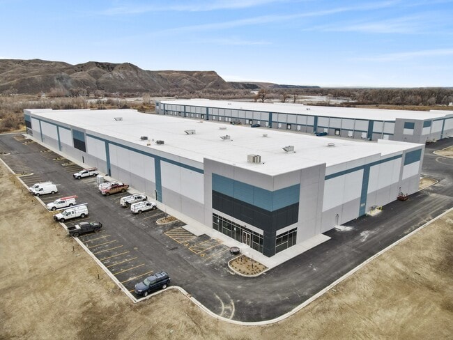
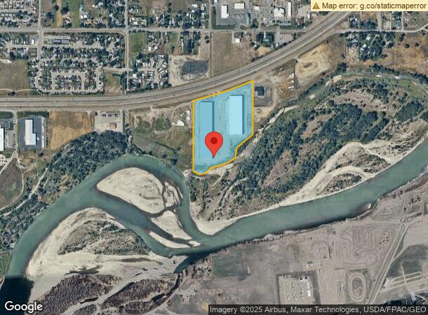
Property Record
3218 S Frontage Rd, Billings, MT 59101
NEARBY LISTINGS FOR SALE OR LEASE
Property Detail
3218 S Frontage Rd
Billings, MT
Cert/Surv 1596 #1
03-0927-15-1-10-01-0000
S15, T01 S, R26 E, C.O.S. 1596, PARCEL 1A, AMD (23)
Commercialnec
Yellowstone
AE
Montana
30111C1270E
2
2024
17 AC
2025
Billings
000901
Other Market Areas
295,400 SF
DEMOGRAPHICS near 3218 S Frontage Rd
1 Mile
3 Mile
5 Mile
2024 Total Population
3,142
35,173
86,706
2029 Population
3,357
37,866
93,291
Pop Growth 2024-2029
+ 6.84%
+ 7.66%
+ 7.59%
Average Age
38
39
40
2024 Total Households
1,096
15,460
37,209
HH Growth 2024-2029
+ 6.84%
+ 7.81%
+ 7.76%
Median Household Inc
$58,067
$51,558
$62,814
Avg Household Size
2.50
2.10
2.20
2024 Avg HH Vehicles
2.00
2.00
2.00
Median Home Value
$181,517
$239,413
$266,463
Median Year Built
1975
1961
1972
Nearby Places
Map Layers
Map Styles
 Street
 Aerial
- Restaurants
- Banks
- Shops
- Fitness
- Groceries
PUBLIC TRANSPORTATION
AIRPORT
Billings Logan International
DRIVE
WALK
Distance
Billings Logan International
26 min
8.5 mi
Freight Ports
Port of Everett
DRIVE
WALK
Distance
Port of Everett
885 min
841.1 mi
SALE & LEASE HISTORY
LISTING DATE
SALE/LEASE

Sep 16, 2024
For Lease
Nov 16, 2022
For Lease
Nearby Properties
Address
Land Use
TOTAL SIZE
Lot Size
Zoning
Address
Land Use
TOTAL SIZE
Lot Size
Zoning
704,701 SF
9.06 AC
MCPZD
Address
Land Use
TOTAL SIZE
Lot Size
Zoning
198,096 SF
7.48 AC
MCPZD
Address
Land Use
TOTAL SIZE
Lot Size
Zoning
9.37 AC
P
Address
Land Use
TOTAL SIZE
Lot Size
Zoning
258,977 SF
18.05 AC
CI
Address
Land Use
TOTAL SIZE
Lot Size
Zoning
213,615 SF
0.96 AC
CBD
Address
Land Use
TOTAL SIZE
Lot Size
Zoning
76,098 SF
0.80 AC
CBD
Address
Land Use
TOTAL SIZE
Lot Size
Zoning
108,000 SF
2.07 AC
CBD
Address
Land Use
TOTAL SIZE
Lot Size
Zoning
145,168 SF
0.96 AC
CBD
Address
Land Use
TOTAL SIZE
Lot Size
Zoning
172.22 AC
Address
Land Use
TOTAL SIZE
Lot Size
Zoning
71,600 SF
0.15 AC
CBD
Address
Land Use
TOTAL SIZE
Lot Size
Zoning
234,444 SF
4.98 AC
MCPZD
Address
Land Use
TOTAL SIZE
Lot Size
Zoning
63,650 SF
4.13 AC
MCPZD
Address
Land Use
TOTAL SIZE
Lot Size
Zoning
118,640 SF
12.55 AC
P
Address
Land Use
TOTAL SIZE
Lot Size
Zoning
1,200 SF
57.17 AC
P
Address
Land Use
TOTAL SIZE
Lot Size
Zoning
409,620 SF
27.42 AC
CI
Address
Land Use
TOTAL SIZE
Lot Size
Zoning
141,186 SF
2.62 AC
CBD
Address
Land Use
TOTAL SIZE
Lot Size
Zoning
111,120 SF
1.91 AC
CBD
Address
Land Use
TOTAL SIZE
Lot Size
Zoning
125,400 SF
2.41 AC
CI
Address
Land Use
TOTAL SIZE
Lot Size
Zoning
90,220 SF
0.96 AC
CBD
Address
Land Use
TOTAL SIZE
Lot Size
Zoning
85,198 SF
0.48 AC
CBD
Address
Land Use
TOTAL SIZE
Lot Size
Zoning
108,563 SF
4.38 AC
CBD
Address
Land Use
TOTAL SIZE
Lot Size
Zoning
60.42 AC
HI
Address
Land Use
TOTAL SIZE
Lot Size
Zoning
20.27 AC
P
Address
Land Use
TOTAL SIZE
Lot Size
Zoning
205,302 SF
0.90 AC
CBD
Address
Land Use
TOTAL SIZE
Lot Size
Zoning
62,136 SF
2.24 AC
MCPZD
Address
Land Use
TOTAL SIZE
Lot Size
Zoning
74,990 SF
0.59 AC
CBD
Address
Land Use
TOTAL SIZE
Lot Size
Zoning
178,736 SF
11.94 AC
HC
Address
Land Use
TOTAL SIZE
Lot Size
Zoning
169,281 SF
11.41 AC
Address
Land Use
TOTAL SIZE
Lot Size
Zoning
87,144 SF
3.65 AC
PZD
The World's #1 Commercial Real Estate Marketplace
Connect with us
© 2026 CoStar Group
The information above has been obtained from sources believed reliable. While we do not doubt its accuracy we have not verified it and make no guarantee, warranty or representation about it. It is your responsibility to independently confirm its accuracy and completeness. Any projections, opinions, assumptions, or estimates used are for example only and do not represent the current or future performance of the property. The value of this transaction to you depends on tax and other factors which should be evaluated by your tax, financial, and legal advisors. You and your advisors should conduct a careful, independent investigation of the property to determine to your satisfaction the suitability of the property for your needs.