Property Record
3219 Commander Dr, Carrollton, TX 75006


Save to a Folder
{{folder.Name}}
{{folder.ListingIds.length}} Properties
{{folder.ListingIds.length}} Property
Create a New Folder
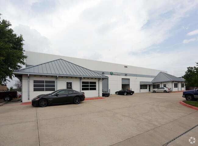
Property Detail
3219 Commander Dr
14003150010070000
BELTWOOD NORTH PH 4 BLK A LT 7 1.426 AC VOL2003120/8369 DD06192003 CO-DC 0031500100700 11400315001
Officebuilding
DALLAS
Z123
Texas
B and X Area of moderate flood hazard, usually the area between the limits of the 100-year and 500-year floods.
7
2025
1.43 AC
2025
Metropolitan/Addison
013722
Dallas/Ft Worth
25,575 SF
Dallas-Fort Worth-Arlington, TX
NEARBY LISTINGS FOR SALE OR LEASE
DEMOGRAPHICS near 3219 Commander Dr
1 mile
3 mile
5 mile
2025 Total Population
14,804
159,970
381,754
2030 Population
15,610
171,395
409,715
Pop Growth 2025-2030
+ 5.44%
+ 7.14%
+ 7.32%
Average Age
38
39
39
2025 Total Households
7,522
76,611
166,348
HH Growth 2025-2030
+ 5.77%
+ 7.34%
+ 7.61%
Median Household Inc
$69,768
$77,659
$88,421
Avg Household Size
1.90
2.00
2.20
2025 Avg HH Vehicles
2.00
2.00
2.00
Median Home Value
$380,938
$402,371
$467,505
Median Year Built
1990
1987
1986
Nearby Places
Map Layers
Map Styles
 Street
 Aerial
Layers
 Traffic
 Biking
Places
Listings with unknown addresses are not visible on the map
- Restaurants
- Banks
- Shops
- Fitness
- Groceries
PUBLIC TRANSPORTATION
COMMUTER RAIL
Trinity Mills Station (A-train - Denton County Transportation Authority)
Drive
Walk
Distance
Trinity Mills Station (A-train - Denton County Transportation Authority)
12 min
6.5 mi
AIRPORT
Dallas Love Field
Drive
Walk
Distance
Dallas Love Field
22 min
13.8 mi
Dallas-Fort Worth International
Drive
Walk
Distance
Dallas-Fort Worth International
26 min
19.0 mi
Freight Ports
Port of Shreveport
Drive
Walk
Distance
Port of Shreveport
225 min
207.2 mi
Nearby Properties
Address
Land Use
TOTAL SIZE
Lot Size
Zoning
Address
Land Use
TOTAL SIZE
Lot Size
Zoning
1,034,981 SF
8.37 AC
Z422
Address
Land Use
TOTAL SIZE
Lot Size
Zoning
1,406,300 SF
6.86 AC
Z236
Address
Land Use
TOTAL SIZE
Lot Size
Zoning
619,645 SF
5.16 AC
Z422
Address
Land Use
TOTAL SIZE
Lot Size
Zoning
597,347 SF
4.40 AC
Z09
Address
Land Use
TOTAL SIZE
Lot Size
Zoning
602,424 SF
31.61 AC
Z236
Address
Land Use
TOTAL SIZE
Lot Size
Zoning
458,855 SF
4.04 AC
Z236
Address
Land Use
TOTAL SIZE
Lot Size
Zoning
417,990 SF
10.42 AC
Address
Land Use
TOTAL SIZE
Lot Size
Zoning
599,705 SF
4.98 AC
Z32
Address
Land Use
TOTAL SIZE
Lot Size
Zoning
429,576 SF
22.03 AC
Z236
Address
Land Use
TOTAL SIZE
Lot Size
Zoning
1,126,832 SF
3.64 AC
Z236
Address
Land Use
TOTAL SIZE
Lot Size
Zoning
482,025 SF
11.73 AC
LC
Address
Land Use
TOTAL SIZE
Lot Size
Zoning
1,294,505 SF
1 AC
SU
Address
Land Use
TOTAL SIZE
Lot Size
Zoning
113,688 SF
72.86 AC
Z274
Address
Land Use
TOTAL SIZE
Lot Size
Zoning
696,563 SF
19.77 AC
Z239
Address
Land Use
TOTAL SIZE
Lot Size
Zoning
435,696 SF
3 AC
PD
Address
Land Use
TOTAL SIZE
Lot Size
Zoning
647,590 SF
4.92 AC
Z123
Address
Land Use
TOTAL SIZE
Lot Size
Zoning
903,882 SF
2.24 AC
Z236
Address
Land Use
TOTAL SIZE
Lot Size
Zoning
284,890 SF
40.44 AC
Z274
Address
Land Use
TOTAL SIZE
Lot Size
Zoning
561,142 SF
4.64 AC
MU-2
Address
Land Use
TOTAL SIZE
Lot Size
Zoning
595,188 SF
6.16 AC
Z239
Address
Land Use
TOTAL SIZE
Lot Size
Zoning
384,424 SF
377.56 AC
Z119
Address
Land Use
TOTAL SIZE
Lot Size
Zoning
561,139 SF
3.64 AC
Z09
Address
Land Use
TOTAL SIZE
Lot Size
Zoning
490,795 SF
9.59 AC
Z118
Address
Land Use
TOTAL SIZE
Lot Size
Zoning
660,842 SF
4.82 AC
Z09
Address
Land Use
TOTAL SIZE
Lot Size
Zoning
739,099 SF
3.34 AC
Z236
Address
Land Use
TOTAL SIZE
Lot Size
Zoning
584,128 SF
3.51 AC
Z241
Address
Land Use
TOTAL SIZE
Lot Size
Zoning
517,362 SF
23.61 AC
MF-2
Address
Land Use
TOTAL SIZE
Lot Size
Zoning
396,669 SF
18.50 AC
Address
Land Use
TOTAL SIZE
Lot Size
Zoning
1,130,618 SF
6.01 AC
Z32
Address
Land Use
TOTAL SIZE
Lot Size
Zoning
534,929 SF
4.19 AC
Z236
The World's #1 Commercial Real Estate Marketplace
Connect with us
© 2026 CoStar Group
The information above has been obtained from sources believed reliable. While we do not doubt its accuracy we have not verified it and make no guarantee, warranty or representation about it. It is your responsibility to independently confirm its accuracy and completeness. Any projections, opinions, assumptions, or estimates used are for example only and do not represent the current or future performance of the property. The value of this transaction to you depends on tax and other factors which should be evaluated by your tax, financial, and legal advisors. You and your advisors should conduct a careful, independent investigation of the property to determine to your satisfaction the suitability of the property for your needs.