Property Record
3219 Rt 198 Way, Laurel, MD 20724
NEARBY LISTINGS FOR SALE OR LEASE
-
-
View all Laurel listings for sale on LoopNet.com
Property Detail
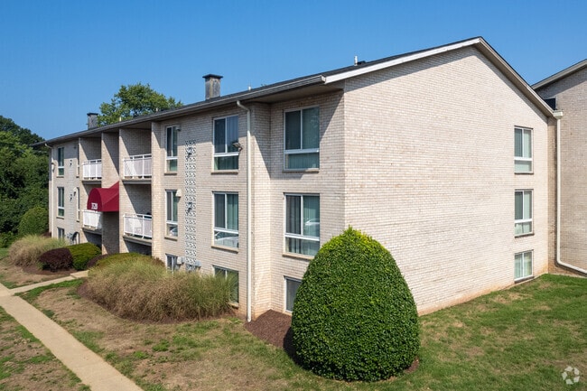
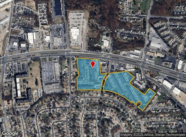
3219 Rt 198 Way
Baltimore-Columbia-Towson, MD
Laurel
04-000-03923603
14.8458 ACRES RT 198 LAUREL
Apartment
Anne Arundel
X
Maryland
24033C0052E
14.84 AC
2024
Maryland City
2025
Baltimore
740501
DEMOGRAPHICS near 3219 Rt 198 Way
1 Mile
3 Mile
5 Mile
2024 Total Population
10,728
83,652
152,719
2029 Population
11,061
83,976
153,846
Pop Growth 2024-2029
+ 3.10%
+ 0.39%
+ 0.74%
Average Age
36
37
37
2024 Total Households
3,621
31,308
55,955
HH Growth 2024-2029
+ 2.95%
+ 0.18%
+ 0.51%
Median Household Inc
$79,738
$88,968
$101,698
Avg Household Size
2.80
2.60
2.60
2024 Avg HH Vehicles
2.00
2.00
2.00
Median Home Value
$340,556
$362,414
$400,960
Median Year Built
1985
1984
1987
Nearby Places
Map Layers
Map Styles
 Street
 Aerial
- Restaurants
- Banks
- Shops
- Fitness
- Groceries
PUBLIC TRANSPORTATION
COMMUTER RAIL
Laurel Racetrack (CAMDEN - WASHINGTON - Maryland Area Regional Commuter Trains (The MARC), Camden Line - Maryland Area Regional Commuter Trains (The MARC))
DRIVE
WALK
Distance
Laurel Racetrack (CAMDEN - WASHINGTON - Maryland Area Regional Commuter Trains (The MARC), Camden Line - Maryland Area Regional Commuter Trains (The MARC))
6 min
1.9 mi
Laurel (CAMDEN - WASHINGTON - Maryland Area Regional Commuter Trains (The MARC), Camden Line - Maryland Area Regional Commuter Trains (The MARC))
DRIVE
WALK
Distance
Laurel (CAMDEN - WASHINGTON - Maryland Area Regional Commuter Trains (The MARC), Camden Line - Maryland Area Regional Commuter Trains (The MARC))
6 min
2.6 mi
AIRPORT
Baltimore/Washington International Thurgood Marshall
DRIVE
WALK
Distance
Baltimore/Washington International Thurgood Marshall
21 min
13.0 mi
Ronald Reagan Washington Ntl
DRIVE
WALK
Distance
Ronald Reagan Washington Ntl
41 min
26.0 mi
Freight Ports
Port of Baltimore
DRIVE
WALK
Distance
Port of Baltimore
31 min
19.6 mi
Nearby Properties
Address
Land Use
TOTAL SIZE
Lot Size
Zoning
Address
Land Use
TOTAL SIZE
Lot Size
Zoning
8,192 SF
13,053.34 AC
R1
Address
Land Use
TOTAL SIZE
Lot Size
Zoning
238,700 SF
7.43 AC
TOD
Address
Land Use
TOTAL SIZE
Lot Size
Zoning
399,715 SF
23.04 AC
LAUR
Address
Land Use
TOTAL SIZE
Lot Size
Zoning
657,100 SF
7.39 AC
LAUR
Address
Land Use
TOTAL SIZE
Lot Size
Zoning
796,368 SF
11.80 AC
R5
Address
Land Use
TOTAL SIZE
Lot Size
Zoning
279,320 SF
15.25 AC
R15
Address
Land Use
TOTAL SIZE
Lot Size
Zoning
376,918 SF
8.55 AC
W1
Address
Land Use
TOTAL SIZE
Lot Size
Zoning
261,969 SF
12.13 AC
R5R10
Address
Land Use
TOTAL SIZE
Lot Size
Zoning
104,067 SF
25.29 AC
RMF20
Address
Land Use
TOTAL SIZE
Lot Size
Zoning
165,236 SF
5.24 AC
LAUR
Address
Land Use
TOTAL SIZE
Lot Size
Zoning
379,264 SF
23.08 AC
LAUR
Address
Land Use
TOTAL SIZE
Lot Size
Zoning
234,264 SF
5.03 AC
W1
Address
Land Use
TOTAL SIZE
Lot Size
Zoning
192,703 SF
6.67 AC
W-1
Address
Land Use
TOTAL SIZE
Lot Size
Zoning
539,758 SF
48.32 AC
M1
Address
Land Use
TOTAL SIZE
Lot Size
Zoning
161,528 SF
10.86 AC
W1
Address
Land Use
TOTAL SIZE
Lot Size
Zoning
16,016 SF
19.95 AC
RA15
Address
Land Use
TOTAL SIZE
Lot Size
Zoning
12,936 SF
19.50 AC
RA15
Address
Land Use
TOTAL SIZE
Lot Size
Zoning
302,887 SF
24.96 AC
LAUR
Address
Land Use
TOTAL SIZE
Lot Size
Zoning
364,609 SF
8.57 AC
R22
Address
Land Use
TOTAL SIZE
Lot Size
Zoning
418,818 SF
48.07 AC
C3
Address
Land Use
TOTAL SIZE
Lot Size
Zoning
16.36 AC
RMF20
Address
Land Use
TOTAL SIZE
Lot Size
Zoning
291,250 SF
30.09 AC
CECLI
Address
Land Use
TOTAL SIZE
Lot Size
Zoning
149,990 SF
10.41 AC
PEC
Address
Land Use
TOTAL SIZE
Lot Size
Zoning
149,990 SF
9.70 AC
PEC
Address
Land Use
TOTAL SIZE
Lot Size
Zoning
304,575 SF
33.71 AC
TOD
Address
Land Use
TOTAL SIZE
Lot Size
Zoning
125,480 SF
11.30 AC
W1
Address
Land Use
TOTAL SIZE
Lot Size
Zoning
15.70 AC
RMF20
Address
Land Use
TOTAL SIZE
Lot Size
Zoning
124,000 SF
15.80 AC
W-1
Address
Land Use
TOTAL SIZE
Lot Size
Zoning
13,624 SF
17.08 AC
RA15
The World's #1 Commercial Real Estate Marketplace
Connect with us
© 2025 CoStar Group
The information above has been obtained from sources believed reliable. While we do not doubt its accuracy we have not verified it and make no guarantee, warranty or representation about it. It is your responsibility to independently confirm its accuracy and completeness. Any projections, opinions, assumptions, or estimates used are for example only and do not represent the current or future performance of the property. The value of this transaction to you depends on tax and other factors which should be evaluated by your tax, financial, and legal advisors. You and your advisors should conduct a careful, independent investigation of the property to determine to your satisfaction the suitability of the property for your needs.