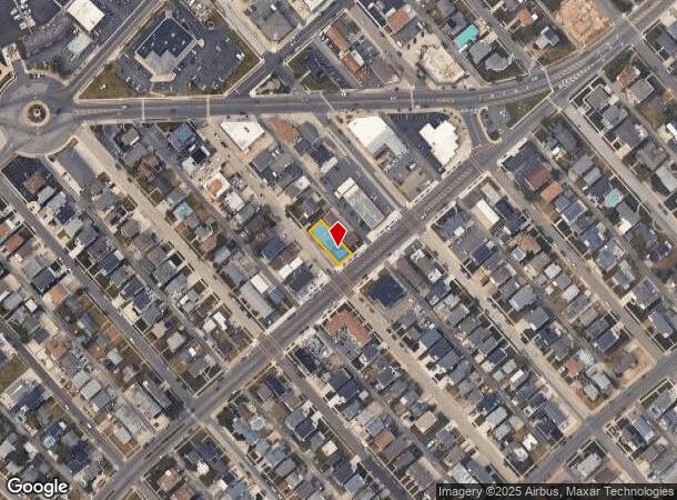
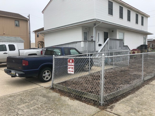
Property Record
3219 W Brigantine Ave, Brigantine, NJ 08203

NEARBY LISTINGS FOR SALE OR LEASE
-
-
View all Brigantine listings for lease on LoopNet.com
Property Detail
3219 W Brigantine Ave
03-02906-0000-00002
Brigantine Bay Club Condominium
Commercialnec
Atlantic
AE
New Jersey
34001C0344F
2
2024
0.13 AC
2025
Atlantic City/Hammonton
010104
Philadelphia
2,516 SF
Atlantic City-Hammonton, NJ
DEMOGRAPHICS near 3219 W Brigantine Ave
1 Mile
3 Mile
5 Mile
2024 Total Population
6,343
27,379
51,913
2029 Population
7,019
28,898
53,531
Pop Growth 2024-2029
+ 10.66%
+ 5.55%
+ 3.12%
Average Age
52
47
42
2024 Total Households
3,195
13,295
22,638
HH Growth 2024-2029
+ 10.52%
+ 5.54%
+ 3.53%
Median Household Inc
$70,728
$45,594
$40,055
Avg Household Size
1.90
2.00
2.20
2024 Avg HH Vehicles
2.00
1.00
1.00
Median Home Value
$392,182
$362,271
$314,218
Median Year Built
1978
1979
1968
Nearby Places
Map Layers
Map Styles
 Street
 Aerial
- Restaurants
- Banks
- Shops
- Fitness
- Groceries
PUBLIC TRANSPORTATION
COMMUTER RAIL
Atlantic City (Atlantic City Line - NJ Transit Commuter Rail (NJ Transit))
DRIVE
WALK
Distance
Atlantic City (Atlantic City Line - NJ Transit Commuter Rail (NJ Transit))
10 min
4.7 mi
Absecon (Atlantic City Line - NJ Transit Commuter Rail (NJ Transit))
DRIVE
WALK
Distance
Absecon (Atlantic City Line - NJ Transit Commuter Rail (NJ Transit))
16 min
9.1 mi
AIRPORT
Atlantic City International
DRIVE
WALK
Distance
Atlantic City International
46 min
17.5 mi
Freight Ports
Broadway Terminal - Pier 5
DRIVE
WALK
Distance
Broadway Terminal - Pier 5
78 min
59.2 mi
SALE & LEASE HISTORY
LISTING DATE
SALE/LEASE

Jul 16, 2020
For Lease
Jul 16, 2020
For Sale
Nearby Properties
Address
Land Use
TOTAL SIZE
Lot Size
Zoning
Address
Land Use
TOTAL SIZE
Lot Size
Zoning
25.97 AC
HNRA
Address
Land Use
TOTAL SIZE
Lot Size
Zoning
Address
Land Use
TOTAL SIZE
Lot Size
Zoning
11.04 AC
HNRA
Address
Land Use
TOTAL SIZE
Lot Size
Zoning
14.73 AC
RVRA
Address
Land Use
TOTAL SIZE
Lot Size
Zoning
14.71 AC
RS-C
Address
Land Use
TOTAL SIZE
Lot Size
Zoning
69.16 AC
HNRA
Address
Land Use
TOTAL SIZE
Lot Size
Zoning
9.90 AC
RS-C
Address
Land Use
TOTAL SIZE
Lot Size
Zoning
3.54 AC
HNRA
Address
Land Use
TOTAL SIZE
Lot Size
Zoning
Address
Land Use
TOTAL SIZE
Lot Size
Zoning
0.78 AC
RS-C
Address
Land Use
TOTAL SIZE
Lot Size
Zoning
7.63 AC
RS-C
Address
Land Use
TOTAL SIZE
Lot Size
Zoning
132 AC
C1
Address
Land Use
TOTAL SIZE
Lot Size
Zoning
1.09 AC
RS-C
Address
Land Use
TOTAL SIZE
Lot Size
Zoning
28,520 SF
47.40 AC
M-C
Address
Land Use
TOTAL SIZE
Lot Size
Zoning
2.75 AC
Address
Land Use
TOTAL SIZE
Lot Size
Zoning
4.30 AC
RS-C
Address
Land Use
TOTAL SIZE
Lot Size
Zoning
10.25 AC
R2
Address
Land Use
TOTAL SIZE
Lot Size
Zoning
8.35 AC
HNRA
Address
Land Use
TOTAL SIZE
Lot Size
Zoning
60 AC
C1
Address
Land Use
TOTAL SIZE
Lot Size
Zoning
2.04 AC
HNRA
Address
Land Use
TOTAL SIZE
Lot Size
Zoning
14.71 AC
RS-C
Address
Land Use
TOTAL SIZE
Lot Size
Zoning
47 AC
Address
Land Use
TOTAL SIZE
Lot Size
Zoning
111,648 SF
2.89 AC
NEIR
Address
Land Use
TOTAL SIZE
Lot Size
Zoning
13,042 SF
9.21 AC
NEIR
Address
Land Use
TOTAL SIZE
Lot Size
Zoning
13.47 AC
B3
Address
Land Use
TOTAL SIZE
Lot Size
Zoning
253,740 SF
2.13 AC
NEIR
Address
Land Use
TOTAL SIZE
Lot Size
Zoning
200,060 SF
2.65 AC
CBD
Address
Land Use
TOTAL SIZE
Lot Size
Zoning
4.55 AC
RVRA
Address
Land Use
TOTAL SIZE
Lot Size
Zoning
24,696 SF
13.20 AC
M-C
Address
Land Use
TOTAL SIZE
Lot Size
Zoning
10.34 AC
RS-C
The World's #1 Commercial Real Estate Marketplace
Connect with us
© 2025 CoStar Group
The information above has been obtained from sources believed reliable. While we do not doubt its accuracy we have not verified it and make no guarantee, warranty or representation about it. It is your responsibility to independently confirm its accuracy and completeness. Any projections, opinions, assumptions, or estimates used are for example only and do not represent the current or future performance of the property. The value of this transaction to you depends on tax and other factors which should be evaluated by your tax, financial, and legal advisors. You and your advisors should conduct a careful, independent investigation of the property to determine to your satisfaction the suitability of the property for your needs.