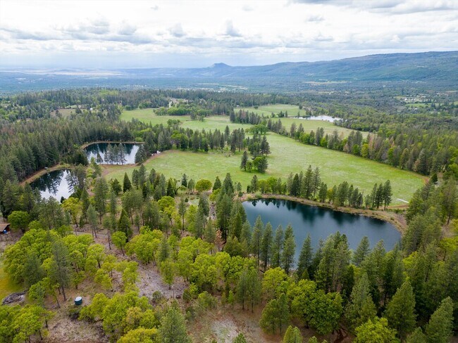
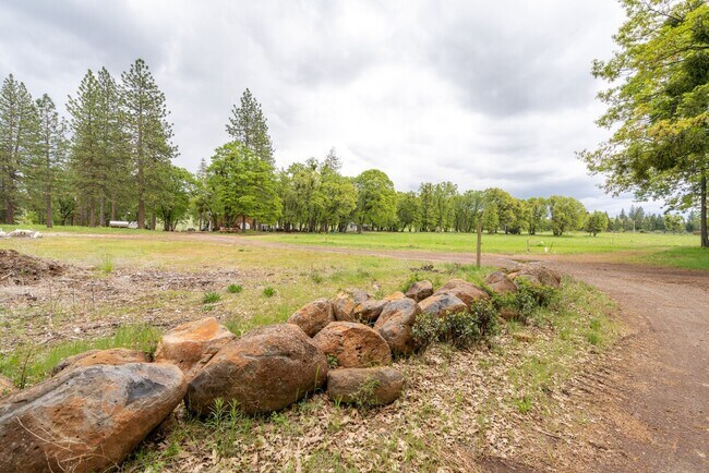
Property Record
32190 Forward Rd, Manton, CA 96059
Property Detail
32190 Forward Rd
011-440-046-000
PTN SEC 26 TWP 30N R1E
Pasture
TEHAMA
EAB871
California
B and X Area of moderate flood hazard, usually the area between the limits of the 100-year and 500-year floods.
117.33 AC
2024
California North Rural Area
2025
Other Market Areas
000100
Red Bluff, CA
1,351 SF
NEARBY LISTINGS FOR SALE OR LEASE
-
-
View all Manton listings for sale on LoopNet.com
DEMOGRAPHICS near 32190 Forward Rd
1 mile
3 mile
5 mile
2025 Total Population
105
370
900
2030 Population
103
363
876
Pop Growth 2025-2030
(1.90%)
(1.89%)
(2.67%)
Average Age
51
50
51
2025 Total Households
46
163
407
HH Growth 2025-2030
(2.17%)
(1.84%)
(2.70%)
Median Household Inc
$66,562
$66,160
$68,138
Avg Household Size
2.10
2.20
2.20
2025 Avg HH Vehicles
2.00
2.00
2.00
Median Home Value
$359,999
$358,823
$298,912
Median Year Built
1977
1977
1980
Nearby Places
Map Layers
Map Styles
 Street
 Aerial
Transit
 Traffic
 Biking
Places
Listings with unknown addresses are not visible on the map
- Restaurants
- Banks
- Shops
- Fitness
- Groceries
PUBLIC TRANSPORTATION
AIRPORT
Redding Regional
Drive
Walk
Distance
Redding Regional
59 min
38.3 mi
Freight Ports
Port of Stockton
Drive
Walk
Distance
Port of Stockton
237 min
207.2 mi
SALE & LEASE HISTORY
LISTING DATE
SALE/LEASE

May 18, 2023
For Sale
Nearby Properties
Address
Land Use
TOTAL SIZE
Lot Size
Zoning
Address
Land Use
TOTAL SIZE
Lot Size
Zoning
7,200 SF
41.69 AC
UABZ
Address
Land Use
TOTAL SIZE
Lot Size
Zoning
2,223 SF
75.70 AC
UA
Address
Land Use
TOTAL SIZE
Lot Size
Zoning
3,778 SF
51.95 AC
R1AMHB
Address
Land Use
TOTAL SIZE
Lot Size
Zoning
1,067 SF
21.60 AC
R1AMHB
Address
Land Use
TOTAL SIZE
Lot Size
Zoning
1,293 SF
188.82 AC
UAB6969
Address
Land Use
TOTAL SIZE
Lot Size
Zoning
3,002 SF
22.48 AC
TPZ
Address
Land Use
TOTAL SIZE
Lot Size
Zoning
4,134 SF
61.15 AC
UABZ
Address
Land Use
TOTAL SIZE
Lot Size
Zoning
2,661 SF
160.88 AC
TP
Address
Land Use
TOTAL SIZE
Lot Size
Zoning
2,176 SF
13.30 AC
R1AMHB
Address
Land Use
TOTAL SIZE
Lot Size
Zoning
960 SF
206.77 AC
UAB6969
Address
Land Use
TOTAL SIZE
Lot Size
Zoning
1,490 SF
0.82 AC
C4SP
Address
Land Use
TOTAL SIZE
Lot Size
Zoning
1,668 SF
9.60 AC
UA
Address
Land Use
TOTAL SIZE
Lot Size
Zoning
610 AC
TPZ
Address
Land Use
TOTAL SIZE
Lot Size
Zoning
1,104 SF
2.84 AC
UABZ
Address
Land Use
TOTAL SIZE
Lot Size
Zoning
1,920 SF
42.75 AC
C-R
Address
Land Use
TOTAL SIZE
Lot Size
Zoning
9.76 AC
R1AMHB
Address
Land Use
TOTAL SIZE
Lot Size
Zoning
18.50 AC
R1AMHB
Address
Land Use
TOTAL SIZE
Lot Size
Zoning
2,272 SF
73.55 AC
TPZ
Address
Land Use
TOTAL SIZE
Lot Size
Zoning
1,305 SF
40 AC
UAAP
Address
Land Use
TOTAL SIZE
Lot Size
Zoning
1,746 SF
3.30 AC
UABZ
Address
Land Use
TOTAL SIZE
Lot Size
Zoning
42.10 AC
TPZ
Address
Land Use
TOTAL SIZE
Lot Size
Zoning
1,664 SF
1 AC
UABZ
Address
Land Use
TOTAL SIZE
Lot Size
Zoning
720 SF
119.75 AC
UAB6969
Address
Land Use
TOTAL SIZE
Lot Size
Zoning
1,342 SF
2 AC
UA
Address
Land Use
TOTAL SIZE
Lot Size
Zoning
576 SF
80 AC
R1AMHB
Address
Land Use
TOTAL SIZE
Lot Size
Zoning
880 SF
13.59 AC
UA
Address
Land Use
TOTAL SIZE
Lot Size
Zoning
17.57 AC
R-R-BA-5
The World's #1 Commercial Real Estate Marketplace
Connect with us
© 2026 CoStar Group
The information above has been obtained from sources believed reliable. While we do not doubt its accuracy we have not verified it and make no guarantee, warranty or representation about it. It is your responsibility to independently confirm its accuracy and completeness. Any projections, opinions, assumptions, or estimates used are for example only and do not represent the current or future performance of the property. The value of this transaction to you depends on tax and other factors which should be evaluated by your tax, financial, and legal advisors. You and your advisors should conduct a careful, independent investigation of the property to determine to your satisfaction the suitability of the property for your needs.