Property Record
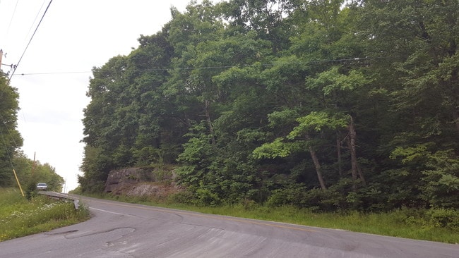
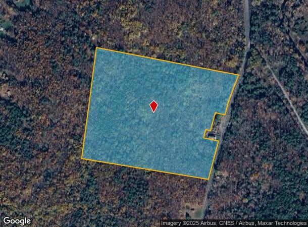
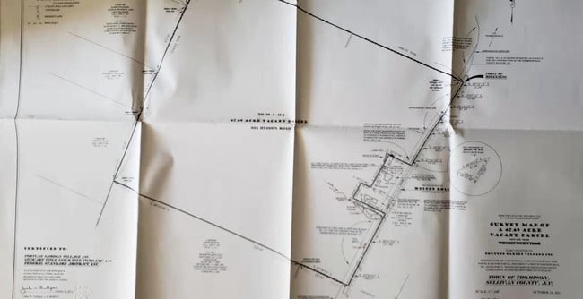
322 Heiden Rd, Monticello, NY 12701
NEARBY LISTINGS FOR SALE OR LEASE
Property Detail
322 Heiden Rd
4689-016-0-0001-041-002
Sullivan
Residentialacreage
New York
X
41.002
36111C0675F
45.55 AC
2025
Hudson Valley Area
2024
Other Market Areas
951701
DEMOGRAPHICS near 322 Heiden Rd
1 Mile
3 Mile
5 Mile
2024 Total Population
70
3,372
20,124
2029 Population
70
3,465
20,961
Pop Growth 2024-2029
0.00%
+ 2.76%
+ 4.16%
Average Age
46
42
39
2024 Total Households
31
1,356
7,816
HH Growth 2024-2029
0.00%
+ 3.02%
+ 4.59%
Median Household Inc
$49,999
$62,413
$49,162
Avg Household Size
2.10
2.40
2.40
2024 Avg HH Vehicles
2.00
2.00
2.00
Median Home Value
$299,999
$198,565
$194,576
Median Year Built
1964
1976
1975
Nearby Places
- Restaurants
- Banks
- Shops
- Fitness
- Groceries
PUBLIC TRANSPORTATION
AIRPORT
New York Stewart International
DRIVE
WALK
Distance
New York Stewart International
53 min
36.2 mi
Freight Ports
Port Newark Container Terminal
DRIVE
WALK
Distance
Port Newark Container Terminal
120 min
93.2 mi
SALE & LEASE HISTORY
LISTING DATE
SALE/LEASE

Sep 16, 2019
For Sale
Nearby Properties
Address
Land Use
TOTAL SIZE
Lot Size
Zoning
Address
Land Use
TOTAL SIZE
Lot Size
Zoning
1,777,903 SF
117.40 AC
PRD
Address
Land Use
TOTAL SIZE
Lot Size
Zoning
423,920 SF
131.50 AC
PRD
Address
Land Use
TOTAL SIZE
Lot Size
Zoning
3,123 SF
48.30 AC
RR
Address
Land Use
TOTAL SIZE
Lot Size
Zoning
80,736 SF
15.74 AC
PBP
Address
Land Use
TOTAL SIZE
Lot Size
Zoning
69,742 SF
21.63 AC
PRD
Address
Land Use
TOTAL SIZE
Lot Size
Zoning
14,841 SF
17.19 AC
HC2
Address
Land Use
TOTAL SIZE
Lot Size
Zoning
104,739 SF
9.68 AC
HC2
Address
Land Use
TOTAL SIZE
Lot Size
Zoning
648 SF
74.20 AC
RR
Address
Land Use
TOTAL SIZE
Lot Size
Zoning
4,950 SF
56.24 AC
PRD
Address
Land Use
TOTAL SIZE
Lot Size
Zoning
54,525 SF
6.33 AC
HC
Address
Land Use
TOTAL SIZE
Lot Size
Zoning
1,984 SF
215.35 AC
PRD
Address
Land Use
TOTAL SIZE
Lot Size
Zoning
53,981 SF
24.71 AC
Address
Land Use
TOTAL SIZE
Lot Size
Zoning
6,042 SF
12.38 AC
EBG
Address
Land Use
TOTAL SIZE
Lot Size
Zoning
56,378 SF
13.65 AC
HC2
Address
Land Use
TOTAL SIZE
Lot Size
Zoning
10,787 SF
13.80 AC
HC
Address
Land Use
TOTAL SIZE
Lot Size
Zoning
55,365 SF
9.33 AC
HC2
Address
Land Use
TOTAL SIZE
Lot Size
Zoning
5,627 SF
10.05 AC
SR
Address
Land Use
TOTAL SIZE
Lot Size
Zoning
55,365 SF
11.85 AC
HC2
Address
Land Use
TOTAL SIZE
Lot Size
Zoning
52,290 SF
26.40 AC
RM
Address
Land Use
TOTAL SIZE
Lot Size
Zoning
29,320 SF
9.31 AC
HC2
Address
Land Use
TOTAL SIZE
Lot Size
Zoning
59,120 SF
7.30 AC
EBV
Address
Land Use
TOTAL SIZE
Lot Size
Zoning
14,689 SF
7.71 AC
RM
Address
Land Use
TOTAL SIZE
Lot Size
Zoning
11,760 SF
8.18 AC
SR
Address
Land Use
TOTAL SIZE
Lot Size
Zoning
2,244 SF
141.85 AC
RR1
Address
Land Use
TOTAL SIZE
Lot Size
Zoning
26,100 SF
4.80 AC
EBV
Address
Land Use
TOTAL SIZE
Lot Size
Zoning
672 SF
172.91 AC
EBG
Address
Land Use
TOTAL SIZE
Lot Size
Zoning
26,000 SF
13.30 AC
EBG
Address
Land Use
TOTAL SIZE
Lot Size
Zoning
28,216 SF
3.09 AC
RM
Address
Land Use
TOTAL SIZE
Lot Size
Zoning
67,000 SF
12.57 AC
PRD
Address
Land Use
TOTAL SIZE
Lot Size
Zoning
22,540 SF
3.43 AC
EBG
The World's #1 Commercial Real Estate Marketplace
Connect with us
© 2025 CoStar Group
The information above has been obtained from sources believed reliable. While we do not doubt its accuracy we have not verified it and make no guarantee, warranty or representation about it. It is your responsibility to independently confirm its accuracy and completeness. Any projections, opinions, assumptions, or estimates used are for example only and do not represent the current or future performance of the property. The value of this transaction to you depends on tax and other factors which should be evaluated by your tax, financial, and legal advisors. You and your advisors should conduct a careful, independent investigation of the property to determine to your satisfaction the suitability of the property for your needs.