Property Record
3220 Goodiron Way, North Charleston, SC 29418
Current Lease Availabilities
NEARBY LISTINGS FOR SALE OR LEASE
Property Detail
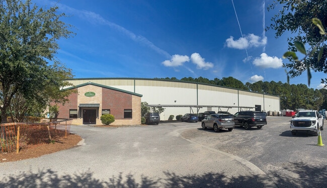
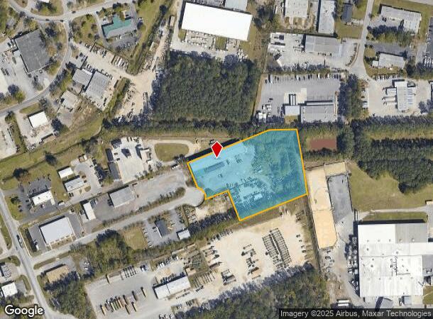
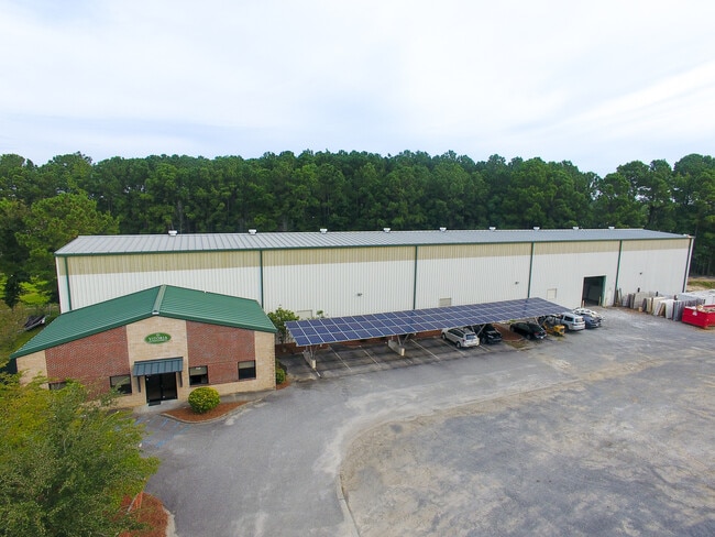
3220 Goodiron Way
Charleston-North Charleston, SC
Property Of Old Nicety Six Land & Timber
397-00-00-510
DESCRIPTION -LOT D
Commercialnec
Charleston
X
South Carolina
45019C0290K
d
2025
3.35 AC
2024
North Charleston
003108
Charleston/N Charleston
1,500 SF
DEMOGRAPHICS near 3220 Goodiron Way
1 Mile
3 Mile
5 Mile
2024 Total Population
3,278
57,934
148,458
2029 Population
3,390
61,088
159,000
Pop Growth 2024-2029
+ 3.42%
+ 5.44%
+ 7.10%
Average Age
37
37
37
2024 Total Households
1,214
22,871
58,248
HH Growth 2024-2029
+ 3.54%
+ 5.48%
+ 7.22%
Median Household Inc
$66,051
$68,560
$71,239
Avg Household Size
2.50
2.40
2.50
2024 Avg HH Vehicles
2.00
2.00
2.00
Median Home Value
$241,195
$275,102
$303,996
Median Year Built
1977
1991
1995
Nearby Places
Map Layers
Map Styles
 Street
 Aerial
- Restaurants
- Banks
- Shops
- Fitness
- Groceries
PUBLIC TRANSPORTATION
COMMUTER RAIL
Charleston Amtrak Station (Palmetto - Amtrak, Silver Meteor - Amtrak)
DRIVE
WALK
Distance
Charleston Amtrak Station (Palmetto - Amtrak, Silver Meteor - Amtrak)
13 min
8.0 mi
AIRPORT
Charleston AFB/International
DRIVE
WALK
Distance
Charleston AFB/International
9 min
4.1 mi
Freight Ports
North Charleston Terminal
DRIVE
WALK
Distance
North Charleston Terminal
13 min
7.6 mi
Nearby Properties
Address
Land Use
TOTAL SIZE
Lot Size
Zoning
Address
Land Use
TOTAL SIZE
Lot Size
Zoning
2,917 SF
11.76 AC
HANAHAN -
Address
Land Use
TOTAL SIZE
Lot Size
Zoning
Address
Land Use
TOTAL SIZE
Lot Size
Zoning
10,172 SF
12.76 AC
Address
Land Use
TOTAL SIZE
Lot Size
Zoning
7,200 SF
8.73 AC
Address
Land Use
TOTAL SIZE
Lot Size
Zoning
4,320 SF
8.14 AC
HANAHAN -
Address
Land Use
TOTAL SIZE
Lot Size
Zoning
21,364 SF
7.71 AC
Address
Land Use
TOTAL SIZE
Lot Size
Zoning
7,176 SF
3.55 AC
HANAHAN -
Address
Land Use
TOTAL SIZE
Lot Size
Zoning
101,011 SF
6.58 AC
Address
Land Use
TOTAL SIZE
Lot Size
Zoning
199,300 SF
13.28 AC
Address
Land Use
TOTAL SIZE
Lot Size
Zoning
48,885 SF
5.02 AC
Address
Land Use
TOTAL SIZE
Lot Size
Zoning
126,385 SF
13.45 AC
Address
Land Use
TOTAL SIZE
Lot Size
Zoning
133.75 AC
MUC_DC
Address
Land Use
TOTAL SIZE
Lot Size
Zoning
48,400 SF
5.76 AC
Address
Land Use
TOTAL SIZE
Lot Size
Zoning
167,100 SF
8 AC
Address
Land Use
TOTAL SIZE
Lot Size
Zoning
58,444 SF
5.61 AC
Address
Land Use
TOTAL SIZE
Lot Size
Zoning
44,300 SF
2.34 AC
Address
Land Use
TOTAL SIZE
Lot Size
Zoning
1,925 SF
8.37 AC
HANAHAN -
Address
Land Use
TOTAL SIZE
Lot Size
Zoning
33.88 AC
Address
Land Use
TOTAL SIZE
Lot Size
Zoning
Address
Land Use
TOTAL SIZE
Lot Size
Zoning
24,648 SF
16.03 AC
HANAHAN -
Address
Land Use
TOTAL SIZE
Lot Size
Zoning
293,825 SF
30.43 AC
Address
Land Use
TOTAL SIZE
Lot Size
Zoning
22,246 SF
5.25 AC
Address
Land Use
TOTAL SIZE
Lot Size
Zoning
1.26 AC
Address
Land Use
TOTAL SIZE
Lot Size
Zoning
1,075 SF
15.81 AC
Address
Land Use
TOTAL SIZE
Lot Size
Zoning
1,286 SF
20 AC
R-2_NC
Address
Land Use
TOTAL SIZE
Lot Size
Zoning
332,013 SF
74.26 AC
R-3_NC
Address
Land Use
TOTAL SIZE
Lot Size
Zoning
5,125 SF
15.99 AC
R-2_NC
Address
Land Use
TOTAL SIZE
Lot Size
Zoning
13,012 SF
1.40 AC
Address
Land Use
TOTAL SIZE
Lot Size
Zoning
16,000 SF
2.61 AC
Address
Land Use
TOTAL SIZE
Lot Size
Zoning
26,250 SF
2.51 AC
The World's #1 Commercial Real Estate Marketplace
Connect with us
© 2025 CoStar Group
The information above has been obtained from sources believed reliable. While we do not doubt its accuracy we have not verified it and make no guarantee, warranty or representation about it. It is your responsibility to independently confirm its accuracy and completeness. Any projections, opinions, assumptions, or estimates used are for example only and do not represent the current or future performance of the property. The value of this transaction to you depends on tax and other factors which should be evaluated by your tax, financial, and legal advisors. You and your advisors should conduct a careful, independent investigation of the property to determine to your satisfaction the suitability of the property for your needs.