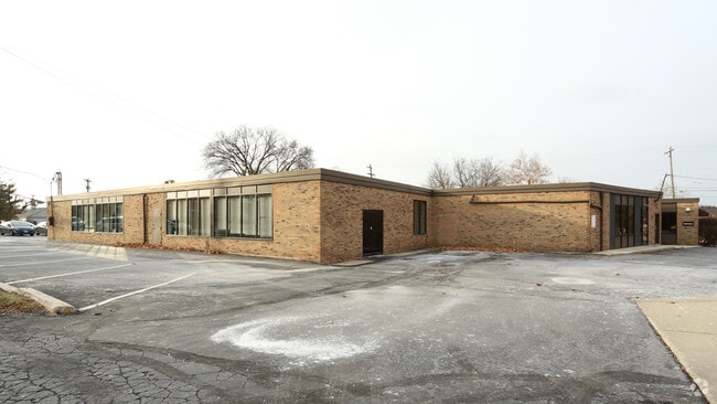
Property Record
3220 Riverside Dr, Upper Arlington, OH 43221


Current Lease Availabilities
NEARBY LISTINGS FOR SALE OR LEASE
Property Detail
3220 Riverside Dr
Columbus, OH
East Cleft On The Scioto
070-005621
DUBLIN ROAD 196 FT W E EAST CLEFT LOT 19
Officebuilding
Franklin
X
Ohio
39049C0164K
19
2024
0.30 AC
2024
Grandview/Upper Arlington
006330
Columbus
10,067 SF
DEMOGRAPHICS near 3220 Riverside Dr
1 Mile
3 Mile
5 Mile
2024 Total Population
7,968
80,914
302,617
2029 Population
7,906
80,985
302,607
Pop Growth 2024-2029
(0.78%)
+ 0.09%
0.00%
Average Age
41
40
36
2024 Total Households
3,341
34,065
129,405
HH Growth 2024-2029
(0.87%)
+ 0.09%
(0.05%)
Median Household Inc
$107,970
$103,182
$75,387
Avg Household Size
2.30
2.30
2.20
2024 Avg HH Vehicles
2.00
2.00
2.00
Median Home Value
$375,170
$363,713
$309,038
Median Year Built
1962
1974
1979
Nearby Places
- Restaurants
- Banks
- Shops
- Fitness
- Groceries
PUBLIC TRANSPORTATION
AIRPORT
John Glenn Columbus International
DRIVE
WALK
Distance
John Glenn Columbus International
22 min
14.3 mi
Rickenbacker International
DRIVE
WALK
Distance
Rickenbacker International
33 min
21.6 mi
Nearby Properties
Address
Land Use
TOTAL SIZE
Lot Size
Zoning
Address
Land Use
TOTAL SIZE
Lot Size
Zoning
1,050,853 SF
328.10 AC
Address
Land Use
TOTAL SIZE
Lot Size
Zoning
611,253 SF
32.89 AC
Address
Land Use
TOTAL SIZE
Lot Size
Zoning
747,391 SF
3.15 AC
Address
Land Use
TOTAL SIZE
Lot Size
Zoning
529,001 SF
28.39 AC
Address
Land Use
TOTAL SIZE
Lot Size
Zoning
10,368 SF
293.98 AC
Address
Land Use
TOTAL SIZE
Lot Size
Zoning
555,347 SF
24.77 AC
Address
Land Use
TOTAL SIZE
Lot Size
Zoning
517,875 SF
3.07 AC
Address
Land Use
TOTAL SIZE
Lot Size
Zoning
961,554 SF
75.09 AC
Address
Land Use
TOTAL SIZE
Lot Size
Zoning
87,654 SF
45.30 AC
Address
Land Use
TOTAL SIZE
Lot Size
Zoning
329,215 SF
8.33 AC
Address
Land Use
TOTAL SIZE
Lot Size
Zoning
34,521 SF
29.23 AC
Address
Land Use
TOTAL SIZE
Lot Size
Zoning
265,341 SF
19.35 AC
Address
Land Use
TOTAL SIZE
Lot Size
Zoning
247,266 SF
7.85 AC
Address
Land Use
TOTAL SIZE
Lot Size
Zoning
50,837 SF
10.12 AC
Address
Land Use
TOTAL SIZE
Lot Size
Zoning
70,995 SF
38.78 AC
Address
Land Use
TOTAL SIZE
Lot Size
Zoning
255,902 SF
8.15 AC
Address
Land Use
TOTAL SIZE
Lot Size
Zoning
156,839 SF
48.45 AC
Address
Land Use
TOTAL SIZE
Lot Size
Zoning
110,344 SF
19.06 AC
Address
Land Use
TOTAL SIZE
Lot Size
Zoning
271,295 SF
14.75 AC
Address
Land Use
TOTAL SIZE
Lot Size
Zoning
142,979 SF
6.50 AC
Address
Land Use
TOTAL SIZE
Lot Size
Zoning
108,828 SF
23.51 AC
Address
Land Use
TOTAL SIZE
Lot Size
Zoning
101,650 SF
5.07 AC
Address
Land Use
TOTAL SIZE
Lot Size
Zoning
98,316 SF
10.81 AC
Address
Land Use
TOTAL SIZE
Lot Size
Zoning
138,003 SF
2.94 AC
Address
Land Use
TOTAL SIZE
Lot Size
Zoning
162,408 SF
1.73 AC
Address
Land Use
TOTAL SIZE
Lot Size
Zoning
Address
Land Use
TOTAL SIZE
Lot Size
Zoning
278,150 SF
1.17 AC
Address
Land Use
TOTAL SIZE
Lot Size
Zoning
232,924 SF
14.30 AC
Address
Land Use
TOTAL SIZE
Lot Size
Zoning
141,439 SF
9.84 AC
Address
Land Use
TOTAL SIZE
Lot Size
Zoning
69,650 SF
15.15 AC
The World's #1 Commercial Real Estate Marketplace
Connect with us
© 2025 CoStar Group
The information above has been obtained from sources believed reliable. While we do not doubt its accuracy we have not verified it and make no guarantee, warranty or representation about it. It is your responsibility to independently confirm its accuracy and completeness. Any projections, opinions, assumptions, or estimates used are for example only and do not represent the current or future performance of the property. The value of this transaction to you depends on tax and other factors which should be evaluated by your tax, financial, and legal advisors. You and your advisors should conduct a careful, independent investigation of the property to determine to your satisfaction the suitability of the property for your needs.