Property Record
3221 Jennings Way, Elko City, NV 89801
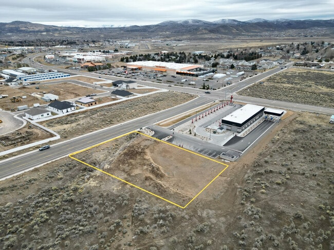
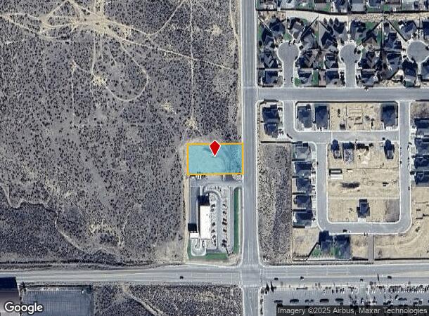
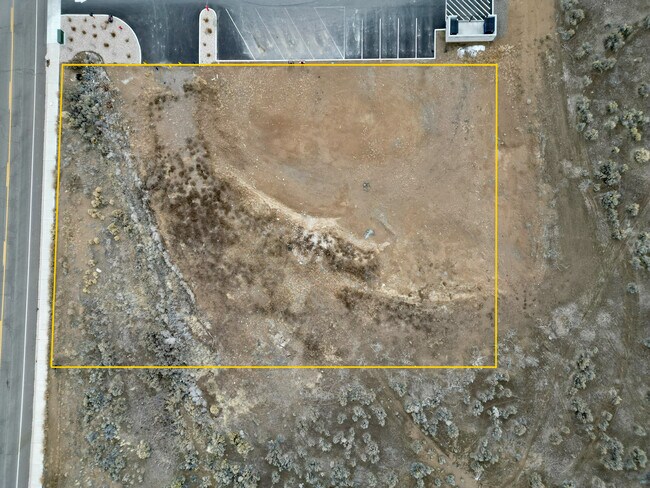
This Property Is For Sale
NEARBY LISTINGS FOR SALE OR LEASE
Property Detail
3221 Jennings Way
Elko, NV
As Shown On That Certain Parcel Map For
001-01A-028
Elko
Recreationalacreage
Nevada
2024
0.68 AC
2025
Carson City/Nevada Area
950800
Other Market Areas
DEMOGRAPHICS near 3221 Jennings Way
1 Mile
3 Mile
5 Mile
2024 Total Population
6,818
21,358
25,261
2029 Population
6,972
21,914
26,051
Pop Growth 2024-2029
+ 2.26%
+ 2.60%
+ 3.13%
Average Age
34
36
36
2024 Total Households
2,419
8,243
9,629
HH Growth 2024-2029
+ 2.19%
+ 2.64%
+ 3.11%
Median Household Inc
$100,708
$85,603
$85,766
Avg Household Size
2.80
2.50
2.60
2024 Avg HH Vehicles
2.00
2.00
2.00
Median Home Value
$322,600
$289,443
$294,915
Median Year Built
2000
1985
1986
Nearby Places
- Restaurants
- Banks
- Shops
- Fitness
- Groceries
PUBLIC TRANSPORTATION
COMMUTER RAIL
Elko Amtrak (California Zephyr - Amtrak)
DRIVE
WALK
Distance
Elko Amtrak (California Zephyr - Amtrak)
8 min
3.5 mi
Freight Ports
Port of Stockton
DRIVE
WALK
Distance
Port of Stockton
491 min
467.2 mi
Nearby Properties
Address
Land Use
TOTAL SIZE
Lot Size
Zoning
Address
Land Use
TOTAL SIZE
Lot Size
Zoning
220,086 SF
31.10 AC
ZLI
Address
Land Use
TOTAL SIZE
Lot Size
Zoning
47,730 SF
479.29 AC
MULT
Address
Land Use
TOTAL SIZE
Lot Size
Zoning
215,373 SF
14.03 AC
ZPQP
Address
Land Use
TOTAL SIZE
Lot Size
Zoning
222,607 SF
10.39 AC
ZC
Address
Land Use
TOTAL SIZE
Lot Size
Zoning
14.71 AC
ZLI
Address
Land Use
TOTAL SIZE
Lot Size
Zoning
107,153 SF
53.50 AC
ZPQP
Address
Land Use
TOTAL SIZE
Lot Size
Zoning
184,595 SF
10.79 AC
ZR
Address
Land Use
TOTAL SIZE
Lot Size
Zoning
212,789 SF
22.72 AC
ZC
Address
Land Use
TOTAL SIZE
Lot Size
Zoning
23,552 SF
78.93 AC
MULT
Address
Land Use
TOTAL SIZE
Lot Size
Zoning
146,208 SF
36.18 AC
MULT
Address
Land Use
TOTAL SIZE
Lot Size
Zoning
1,253 SF
4 AC
ZR
Address
Land Use
TOTAL SIZE
Lot Size
Zoning
105,625 SF
11.18 AC
ZC
Address
Land Use
TOTAL SIZE
Lot Size
Zoning
57,884 SF
1.89 AC
ZC
Address
Land Use
TOTAL SIZE
Lot Size
Zoning
54,982 SF
2.17 AC
ZC
Address
Land Use
TOTAL SIZE
Lot Size
Zoning
53,073 SF
2.32 AC
ZC
Address
Land Use
TOTAL SIZE
Lot Size
Zoning
3,234 SF
5.38 AC
ZC
Address
Land Use
TOTAL SIZE
Lot Size
Zoning
59,525 SF
5.91 AC
ZC
Address
Land Use
TOTAL SIZE
Lot Size
Zoning
166,621 SF
1.40 AC
ZC
Address
Land Use
TOTAL SIZE
Lot Size
Zoning
29,193 SF
3.47 AC
ZPQP
Address
Land Use
TOTAL SIZE
Lot Size
Zoning
43,470 SF
1.82 AC
ZC
Address
Land Use
TOTAL SIZE
Lot Size
Zoning
57,628 SF
2.79 AC
ZC
Address
Land Use
TOTAL SIZE
Lot Size
Zoning
96,349 SF
6.49 AC
ZC
Address
Land Use
TOTAL SIZE
Lot Size
Zoning
49,124 SF
1.50 AC
ZC
Address
Land Use
TOTAL SIZE
Lot Size
Zoning
32,520 SF
2.29 AC
ZLI
Address
Land Use
TOTAL SIZE
Lot Size
Zoning
36,897 SF
2.57 AC
ZPQP
Address
Land Use
TOTAL SIZE
Lot Size
Zoning
98,533 SF
6.66 AC
MULT
Address
Land Use
TOTAL SIZE
Lot Size
Zoning
79,455 SF
9.99 AC
ZC
Address
Land Use
TOTAL SIZE
Lot Size
Zoning
34,972 SF
7.96 AC
ZPQP
Address
Land Use
TOTAL SIZE
Lot Size
Zoning
68,508 SF
7.73 AC
ZC
Address
Land Use
TOTAL SIZE
Lot Size
Zoning
53,947 SF
5.46 AC
ZC
The World's #1 Commercial Real Estate Marketplace
Connect with us
© 2025 CoStar Group
The information above has been obtained from sources believed reliable. While we do not doubt its accuracy we have not verified it and make no guarantee, warranty or representation about it. It is your responsibility to independently confirm its accuracy and completeness. Any projections, opinions, assumptions, or estimates used are for example only and do not represent the current or future performance of the property. The value of this transaction to you depends on tax and other factors which should be evaluated by your tax, financial, and legal advisors. You and your advisors should conduct a careful, independent investigation of the property to determine to your satisfaction the suitability of the property for your needs.