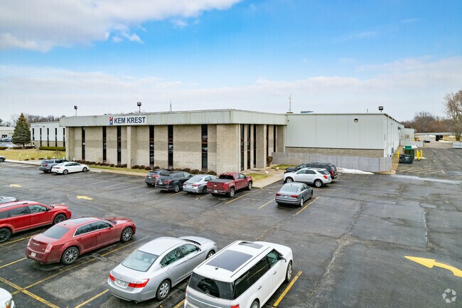
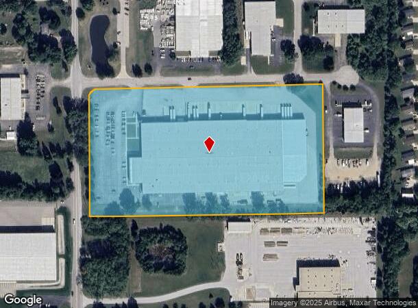
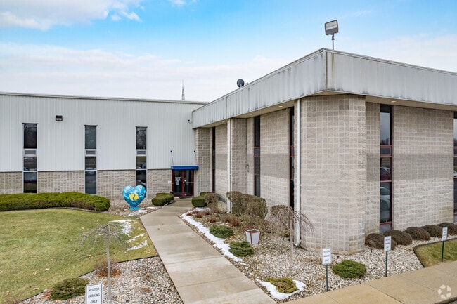
Property Record
3221 Magnum Dr, Elkhart, IN 46516
NEARBY LISTINGS FOR SALE OR LEASE
Property Detail
3221 Magnum Dr
Elkhart-Goshen, IN
Middlebury
20-06-11-251-007.000-011
MIDDLEBURY ST INDUSTRIAL PK LOT 7 & W 130 LOT 6
Warehouse
Elkhart
X
Indiana
18039C0141D
7,6
2023
12.55 AC
2024
Outlying Elkhart County
001902
South Bend/Mishawaka
217,300 SF
DEMOGRAPHICS near 3221 Magnum Dr
1 Mile
3 Mile
5 Mile
2024 Total Population
4,446
44,395
90,066
2029 Population
4,417
44,488
90,225
Pop Growth 2024-2029
(0.65%)
+ 0.21%
+ 0.18%
Average Age
38
38
38
2024 Total Households
1,730
16,813
33,623
HH Growth 2024-2029
(0.52%)
+ 0.33%
+ 0.22%
Median Household Inc
$77,162
$55,231
$54,333
Avg Household Size
2.50
2.50
2.60
2024 Avg HH Vehicles
2.00
2.00
2.00
Median Home Value
$191,564
$159,981
$155,490
Median Year Built
1988
1974
1973
Nearby Places
- Restaurants
- Banks
- Shops
- Fitness
- Groceries
PUBLIC TRANSPORTATION
COMMUTER RAIL
Elkhart Amtrak Station (Capitol Limited - Amtrak, Lake Shore Limited - Amtrak)
DRIVE
WALK
Distance
Elkhart Amtrak Station (Capitol Limited - Amtrak, Lake Shore Limited - Amtrak)
7 min
3.3 mi
AIRPORT
South Bend International
DRIVE
WALK
Distance
South Bend International
46 min
30.1 mi
Freight Ports
Port of Toledo
DRIVE
WALK
Distance
Port of Toledo
169 min
139.7 mi
Nearby Properties
Address
Land Use
TOTAL SIZE
Lot Size
Zoning
Address
Land Use
TOTAL SIZE
Lot Size
Zoning
133,214 SF
0.30 AC
ZO01
Address
Land Use
TOTAL SIZE
Lot Size
Zoning
863,219 SF
25.67 AC
M-2
Address
Land Use
TOTAL SIZE
Lot Size
Zoning
351,795 SF
82.33 AC
ZO01
Address
Land Use
TOTAL SIZE
Lot Size
Zoning
316,104 SF
71.01 AC
ZO01
Address
Land Use
TOTAL SIZE
Lot Size
Zoning
504,647 SF
21.55 AC
ZO01
Address
Land Use
TOTAL SIZE
Lot Size
Zoning
59,994 SF
46.12 AC
ZO01
Address
Land Use
TOTAL SIZE
Lot Size
Zoning
243,442 SF
6.54 AC
ZO01
Address
Land Use
TOTAL SIZE
Lot Size
Zoning
345,810 SF
31.17 AC
Address
Land Use
TOTAL SIZE
Lot Size
Zoning
546,931 SF
59.73 AC
ZO01
Address
Land Use
TOTAL SIZE
Lot Size
Zoning
276,920 SF
18.45 AC
ZO01
Address
Land Use
TOTAL SIZE
Lot Size
Zoning
96,930 SF
20.94 AC
ZO01
Address
Land Use
TOTAL SIZE
Lot Size
Zoning
338,388 SF
36.41 AC
ZO01
Address
Land Use
TOTAL SIZE
Lot Size
Zoning
356,836 SF
27.94 AC
Address
Land Use
TOTAL SIZE
Lot Size
Zoning
276,377 SF
29.49 AC
ZO01
Address
Land Use
TOTAL SIZE
Lot Size
Zoning
355,938 SF
20.72 AC
Address
Land Use
TOTAL SIZE
Lot Size
Zoning
238,198 SF
11.18 AC
ZO01
Address
Land Use
TOTAL SIZE
Lot Size
Zoning
92,926 SF
14.29 AC
Address
Land Use
TOTAL SIZE
Lot Size
Zoning
129,147 SF
3.23 AC
Address
Land Use
TOTAL SIZE
Lot Size
Zoning
227,288 SF
11.12 AC
Address
Land Use
TOTAL SIZE
Lot Size
Zoning
81,272 SF
32.51 AC
ZO01
Address
Land Use
TOTAL SIZE
Lot Size
Zoning
294,230 SF
22.37 AC
ZO01
Address
Land Use
TOTAL SIZE
Lot Size
Zoning
289,195 SF
48.88 AC
ZO01
Address
Land Use
TOTAL SIZE
Lot Size
Zoning
212,960 SF
10 AC
ZO01
Address
Land Use
TOTAL SIZE
Lot Size
Zoning
199,800 SF
13 AC
ZO01
Address
Land Use
TOTAL SIZE
Lot Size
Zoning
56,310 SF
2.85 AC
ZO01
Address
Land Use
TOTAL SIZE
Lot Size
Zoning
258,244 SF
9.99 AC
ZO01
Address
Land Use
TOTAL SIZE
Lot Size
Zoning
246,553 SF
22.11 AC
ZO01
Address
Land Use
TOTAL SIZE
Lot Size
Zoning
47,495 SF
7.84 AC
ZO01
Address
Land Use
TOTAL SIZE
Lot Size
Zoning
128,758 SF
6.28 AC
ZO01
Address
Land Use
TOTAL SIZE
Lot Size
Zoning
107,219 SF
6.46 AC
ZO01
The World's #1 Commercial Real Estate Marketplace
Connect with us
© 2025 CoStar Group
The information above has been obtained from sources believed reliable. While we do not doubt its accuracy we have not verified it and make no guarantee, warranty or representation about it. It is your responsibility to independently confirm its accuracy and completeness. Any projections, opinions, assumptions, or estimates used are for example only and do not represent the current or future performance of the property. The value of this transaction to you depends on tax and other factors which should be evaluated by your tax, financial, and legal advisors. You and your advisors should conduct a careful, independent investigation of the property to determine to your satisfaction the suitability of the property for your needs.