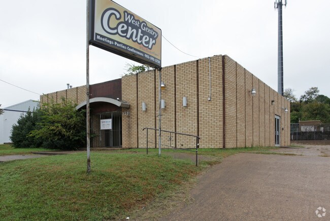
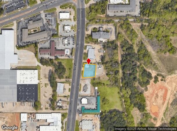
Property Record
3221 W Gentry Pky, Tyler, TX 75702
NEARBY LISTINGS FOR SALE OR LEASE
Property Detail
3221 W Gentry Pky
Tyler, TX
Building Blocks Center Addn U-1
1-50000-1200-00-018070
BUILDING BLOCKS CENTER ADDN U-1BLOCK 1200 LOT 18G
Officebuilding
Smith
X
Texas
48423C0240D
18g
2024
0.49 AC
2025
Tyler & Longview
000201
Other Market Areas
2,030 SF
DEMOGRAPHICS near 3221 W Gentry Pky
1 Mile
3 Mile
5 Mile
2024 Total Population
4,411
34,003
73,037
2029 Population
4,743
37,093
79,543
Pop Growth 2024-2029
+ 7.53%
+ 9.09%
+ 8.91%
Average Age
36
35
36
2024 Total Households
1,494
11,296
25,774
HH Growth 2024-2029
+ 7.03%
+ 8.64%
+ 8.35%
Median Household Inc
$49,070
$44,585
$49,437
Avg Household Size
2.80
2.80
2.60
2024 Avg HH Vehicles
2.00
2.00
2.00
Median Home Value
$72,273
$88,363
$135,196
Median Year Built
1965
1964
1968
Nearby Places
Map Layers
Map Styles
 Street
 Aerial
- Restaurants
- Banks
- Shops
- Fitness
- Groceries
PUBLIC TRANSPORTATION
AIRPORT
Tyler Pounds Regional
DRIVE
WALK
Distance
Tyler Pounds Regional
15 min
7.7 mi
Freight Ports
Port of Shreveport
DRIVE
WALK
Distance
Port of Shreveport
121 min
106.7 mi
SALE & LEASE HISTORY
LISTING DATE
SALE/LEASE

May 05, 2021
For Sale
May 04, 2022
For Lease
Nearby Properties
Address
Land Use
TOTAL SIZE
Lot Size
Zoning
Address
Land Use
TOTAL SIZE
Lot Size
Zoning
39.16 AC
C2
Address
Land Use
TOTAL SIZE
Lot Size
Zoning
Address
Land Use
TOTAL SIZE
Lot Size
Zoning
31.74 AC
Address
Land Use
TOTAL SIZE
Lot Size
Zoning
1.78 AC
DBAC
Address
Land Use
TOTAL SIZE
Lot Size
Zoning
Address
Land Use
TOTAL SIZE
Lot Size
Zoning
Address
Land Use
TOTAL SIZE
Lot Size
Zoning
187.64 AC
R1A
Address
Land Use
TOTAL SIZE
Lot Size
Zoning
Address
Land Use
TOTAL SIZE
Lot Size
Zoning
63 AC
R1A
Address
Land Use
TOTAL SIZE
Lot Size
Zoning
207,919 SF
1.90 AC
DBAC
Address
Land Use
TOTAL SIZE
Lot Size
Zoning
22.85 AC
Address
Land Use
TOTAL SIZE
Lot Size
Zoning
Address
Land Use
TOTAL SIZE
Lot Size
Zoning
2,802 SF
14 AC
RMF
Address
Land Use
TOTAL SIZE
Lot Size
Zoning
25.54 AC
INT
Address
Land Use
TOTAL SIZE
Lot Size
Zoning
181,260 SF
2.06 AC
DBAC
Address
Land Use
TOTAL SIZE
Lot Size
Zoning
14.16 AC
Address
Land Use
TOTAL SIZE
Lot Size
Zoning
129,070 SF
3.75 AC
Address
Land Use
TOTAL SIZE
Lot Size
Zoning
22,500 SF
6.98 AC
Address
Land Use
TOTAL SIZE
Lot Size
Zoning
43,300 SF
2.17 AC
DBAC
Address
Land Use
TOTAL SIZE
Lot Size
Zoning
205,196 SF
25.19 AC
C2
Address
Land Use
TOTAL SIZE
Lot Size
Zoning
14.02 AC
R2
Address
Land Use
TOTAL SIZE
Lot Size
Zoning
Address
Land Use
TOTAL SIZE
Lot Size
Zoning
520,081 SF
24.62 AC
M2
Address
Land Use
TOTAL SIZE
Lot Size
Zoning
2.38 AC
DBAC
Address
Land Use
TOTAL SIZE
Lot Size
Zoning
3,222 SF
7.43 AC
RMF
Address
Land Use
TOTAL SIZE
Lot Size
Zoning
Address
Land Use
TOTAL SIZE
Lot Size
Zoning
1.25 AC
Address
Land Use
TOTAL SIZE
Lot Size
Zoning
80,000 SF
2.30 AC
DBAC
Address
Land Use
TOTAL SIZE
Lot Size
Zoning
3,490 SF
12.92 AC
RMF
Address
Land Use
TOTAL SIZE
Lot Size
Zoning
111,048 SF
10 AC
RMF
The World's #1 Commercial Real Estate Marketplace
Connect with us
© 2025 CoStar Group
The information above has been obtained from sources believed reliable. While we do not doubt its accuracy we have not verified it and make no guarantee, warranty or representation about it. It is your responsibility to independently confirm its accuracy and completeness. Any projections, opinions, assumptions, or estimates used are for example only and do not represent the current or future performance of the property. The value of this transaction to you depends on tax and other factors which should be evaluated by your tax, financial, and legal advisors. You and your advisors should conduct a careful, independent investigation of the property to determine to your satisfaction the suitability of the property for your needs.