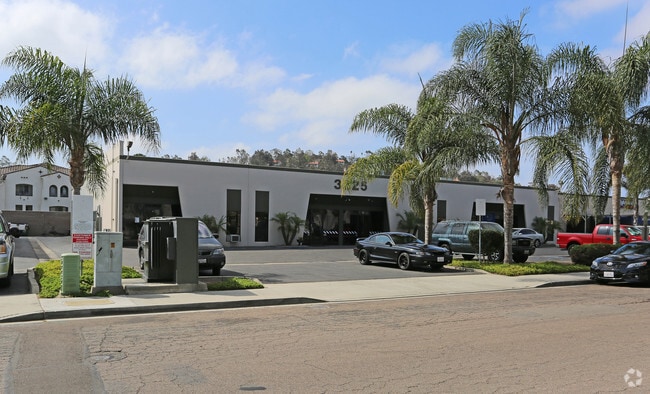
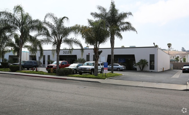
Property Record
3225 Roymar Rd, Oceanside, CA 92058

Property Detail
3225 Roymar Rd
160-271-19
PAR G-2 TR PM06109
Warehouse
San Diego
IL
California
A99 Areas with a 1% annual chance of flooding that will be protected by a Federal flood control system where construction has reached specified legal requirements.
0.70 AC
2024
Oceanside
2025
San Diego
018616
San Diego-Chula Vista-Carlsbad, CA
14,400 SF
NEARBY LISTINGS FOR SALE OR LEASE
DEMOGRAPHICS near 3225 Roymar Rd
1 mile
3 mile
5 mile
2025 Total Population
8,248
106,284
229,481
2030 Population
8,308
107,615
231,290
Pop Growth 2025-2030
+ 0.73%
+ 1.25%
+ 0.79%
Average Age
41
39
39
2025 Total Households
2,782
37,642
79,811
HH Growth 2025-2030
+ 0.47%
+ 1.54%
+ 0.93%
Median Household Inc
$88,105
$85,549
$94,905
Avg Household Size
2.80
2.60
2.60
2025 Avg HH Vehicles
2.00
2.00
2.00
Median Home Value
$778,480
$750,402
$789,598
Median Year Built
1984
1982
1983
Nearby Places
Map Layers
Map Styles
 Street
 Aerial
Transit
 Traffic
 Biking
Places
Listings with unknown addresses are not visible on the map
- Restaurants
- Banks
- Shops
- Fitness
- Groceries
PUBLIC TRANSPORTATION
COMMUTER RAIL
Oceanside Transit Center (Orange County Line - Southern California Regional Rail Authority (Metrolink))
Drive
Walk
Distance
Oceanside Transit Center (Orange County Line - Southern California Regional Rail Authority (Metrolink))
8 min
3.2 mi
Carlsbad Village (Coaster - San Diego North County Transit District (Coaster/Sprinter/Breeze))
Drive
Walk
Distance
Carlsbad Village (Coaster - San Diego North County Transit District (Coaster/Sprinter/Breeze))
12 min
6.7 mi
AIRPORT
San Diego International
Drive
Walk
Distance
San Diego International
49 min
38.7 mi
Freight Ports
Port of San Diego
Drive
Walk
Distance
Port of San Diego
55 min
43.2 mi
SALE & LEASE HISTORY
LISTING DATE
SALE/LEASE

Oct 16, 2023
For Lease
Nearby Properties
Address
Land Use
TOTAL SIZE
Lot Size
Zoning
Address
Land Use
TOTAL SIZE
Lot Size
Zoning
20.96 AC
SP-1-84 (I
Address
Land Use
TOTAL SIZE
Lot Size
Zoning
1.38 AC
C
Address
Land Use
TOTAL SIZE
Lot Size
Zoning
15.74 AC
SP-1-84 (I
Address
Land Use
TOTAL SIZE
Lot Size
Zoning
9,999 SF
5.28 AC
C2
Address
Land Use
TOTAL SIZE
Lot Size
Zoning
31.94 AC
RM-B
Address
Land Use
TOTAL SIZE
Lot Size
Zoning
1.38 AC
C
Address
Land Use
TOTAL SIZE
Lot Size
Zoning
9.22 AC
RH
Address
Land Use
TOTAL SIZE
Lot Size
Zoning
12 AC
SP-1-09
Address
Land Use
TOTAL SIZE
Lot Size
Zoning
4.26 AC
C-2
Address
Land Use
TOTAL SIZE
Lot Size
Zoning
1.77 AC
C-2
Address
Land Use
TOTAL SIZE
Lot Size
Zoning
1.14 AC
C
Address
Land Use
TOTAL SIZE
Lot Size
Zoning
8.01 AC
PD-19-H
Address
Land Use
TOTAL SIZE
Lot Size
Zoning
96,240 SF
22.25 AC
PD-2
Address
Land Use
TOTAL SIZE
Lot Size
Zoning
85,000 SF
4.40 AC
CC
Address
Land Use
TOTAL SIZE
Lot Size
Zoning
5.24 AC
SP-1-09
Address
Land Use
TOTAL SIZE
Lot Size
Zoning
19.51 AC
C-2-Q
Address
Land Use
TOTAL SIZE
Lot Size
Zoning
10.63 AC
RD-M
Address
Land Use
TOTAL SIZE
Lot Size
Zoning
1.02 AC
D-1
Address
Land Use
TOTAL SIZE
Lot Size
Zoning
4.68 AC
D-6B
Address
Land Use
TOTAL SIZE
Lot Size
Zoning
15.02 AC
SP-1-84 (I
Address
Land Use
TOTAL SIZE
Lot Size
Zoning
25.16 AC
SP-1-84 (I
Address
Land Use
TOTAL SIZE
Lot Size
Zoning
11.60 AC
RM-C
Address
Land Use
TOTAL SIZE
Lot Size
Zoning
10,500 SF
43.77 AC
RM-A-SMH
Address
Land Use
TOTAL SIZE
Lot Size
Zoning
78,489 SF
2.67 AC
PD-1 (IL)
Address
Land Use
TOTAL SIZE
Lot Size
Zoning
83,995 SF
5.88 AC
PD-1 (IL)
Address
Land Use
TOTAL SIZE
Lot Size
Zoning
15.81 AC
SP-1-84 (I
Address
Land Use
TOTAL SIZE
Lot Size
Zoning
64,722 SF
2.17 AC
D-1
Address
Land Use
TOTAL SIZE
Lot Size
Zoning
2.98 AC
SP-1-84 (I
Address
Land Use
TOTAL SIZE
Lot Size
Zoning
6,024 SF
6.92 AC
VC
Address
Land Use
TOTAL SIZE
Lot Size
Zoning
99,771 SF
4.22 AC
SP-1-84
The World's #1 Commercial Real Estate Marketplace
Connect with us
© 2026 CoStar Group
The information above has been obtained from sources believed reliable. While we do not doubt its accuracy we have not verified it and make no guarantee, warranty or representation about it. It is your responsibility to independently confirm its accuracy and completeness. Any projections, opinions, assumptions, or estimates used are for example only and do not represent the current or future performance of the property. The value of this transaction to you depends on tax and other factors which should be evaluated by your tax, financial, and legal advisors. You and your advisors should conduct a careful, independent investigation of the property to determine to your satisfaction the suitability of the property for your needs.