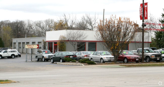
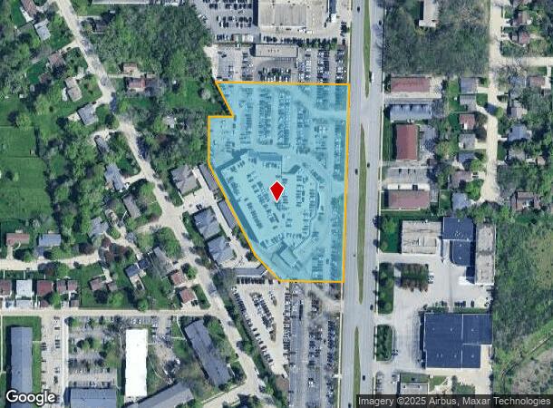
Property Record
3225 S 108 St, , WI
NEARBY LISTINGS FOR SALE OR LEASE
Property Detail
3225 S 108 St
Milwaukee/Madison
PARCELS 1 AND 2 OF CERTIFIED SURVEY MAP NO. 4789, RECORDED ON JULY 30, 1986, IN REEL 1927 OF CERTIFIED SURVEY MAPS, ON IMAGES 571-574, AS DOCUMENT NO. 5943608, BEING A REDIVISION OF PARCEL 2 OF CERTIFIED SURVEY MAP NO. 4732, BEING A PART OF THE NORTH
Milwaukee-Waukesha-West Allis, WI
Milwaukee
523-9946-010
Wisconsin
Commercialnec
5.29 AC
2023
West Allis
2024
DEMOGRAPHICS near 3225 S 108 St
1 Mile
3 Mile
5 Mile
2024 Total Population
10,315
107,693
244,089
2029 Population
10,027
106,465
241,733
Pop Growth 2024-2029
(2.79%)
(1.14%)
(0.97%)
Average Age
41
43
41
2024 Total Households
4,723
48,246
106,721
HH Growth 2024-2029
(2.84%)
(1.22%)
(1.03%)
Median Household Inc
$66,202
$69,720
$71,447
Avg Household Size
2.10
2.20
2.20
2024 Avg HH Vehicles
2.00
2.00
2.00
Median Home Value
$231,232
$219,787
$232,866
Median Year Built
1968
1963
1961
Nearby Places
Map Layers
Map Styles
 Street
 Aerial
- Restaurants
- Banks
- Shops
- Fitness
- Groceries
PUBLIC TRANSPORTATION
COMMUTER RAIL
Milwaukee (Empire Builder - Amtrak)
DRIVE
WALK
Distance
Milwaukee (Empire Builder - Amtrak)
16 min
9.7 mi
General Mitchell Intl. Airport Amtrak Station (Hiawatha Service - Amtrak)
DRIVE
WALK
Distance
General Mitchell Intl. Airport Amtrak Station (Hiawatha Service - Amtrak)
19 min
9.9 mi
AIRPORT
General Mitchell International
DRIVE
WALK
Distance
General Mitchell International
19 min
10.1 mi
Freight Ports
Port Milwaukee
DRIVE
WALK
Distance
Port Milwaukee
18 min
12.0 mi
Nearby Properties
Address
Land Use
TOTAL SIZE
Lot Size
Zoning
Address
Land Use
TOTAL SIZE
Lot Size
Zoning
4.07 AC
Address
Land Use
TOTAL SIZE
Lot Size
Zoning
6.74 AC
Address
Land Use
TOTAL SIZE
Lot Size
Zoning
20.36 AC
Address
Land Use
TOTAL SIZE
Lot Size
Zoning
5.12 AC
Address
Land Use
TOTAL SIZE
Lot Size
Zoning
234,132 SF
22.70 AC
RM1
Address
Land Use
TOTAL SIZE
Lot Size
Zoning
8.70 AC
Address
Land Use
TOTAL SIZE
Lot Size
Zoning
13.39 AC
Address
Land Use
TOTAL SIZE
Lot Size
Zoning
18.79 AC
Address
Land Use
TOTAL SIZE
Lot Size
Zoning
16.84 AC
Address
Land Use
TOTAL SIZE
Lot Size
Zoning
20.61 AC
TL
Address
Land Use
TOTAL SIZE
Lot Size
Zoning
213,840 SF
13.95 AC
PUDR5
Address
Land Use
TOTAL SIZE
Lot Size
Zoning
174,510 SF
7.37 AC
PD
Address
Land Use
TOTAL SIZE
Lot Size
Zoning
158,246 SF
11.34 AC
RM1
Address
Land Use
TOTAL SIZE
Lot Size
Zoning
5.31 AC
Address
Land Use
TOTAL SIZE
Lot Size
Zoning
229,921 SF
8.07 AC
PUD
Address
Land Use
TOTAL SIZE
Lot Size
Zoning
66,893 SF
6.75 AC
B2
Address
Land Use
TOTAL SIZE
Lot Size
Zoning
Address
Land Use
TOTAL SIZE
Lot Size
Zoning
51.76 AC
Address
Land Use
TOTAL SIZE
Lot Size
Zoning
Address
Land Use
TOTAL SIZE
Lot Size
Zoning
Address
Land Use
TOTAL SIZE
Lot Size
Zoning
182,736 SF
7.88 AC
RM1
Address
Land Use
TOTAL SIZE
Lot Size
Zoning
Address
Land Use
TOTAL SIZE
Lot Size
Zoning
Address
Land Use
TOTAL SIZE
Lot Size
Zoning
Address
Land Use
TOTAL SIZE
Lot Size
Zoning
Address
Land Use
TOTAL SIZE
Lot Size
Zoning
99,648 SF
10.87 AC
B1
Address
Land Use
TOTAL SIZE
Lot Size
Zoning
199,064 SF
7.04 AC
RM1
Address
Land Use
TOTAL SIZE
Lot Size
Zoning
3.88 AC
COMMERCIAL
Address
Land Use
TOTAL SIZE
Lot Size
Zoning
Address
Land Use
TOTAL SIZE
Lot Size
Zoning
6.99 AC
The World's #1 Commercial Real Estate Marketplace
Connect with us
© 2025 CoStar Group
The information above has been obtained from sources believed reliable. While we do not doubt its accuracy we have not verified it and make no guarantee, warranty or representation about it. It is your responsibility to independently confirm its accuracy and completeness. Any projections, opinions, assumptions, or estimates used are for example only and do not represent the current or future performance of the property. The value of this transaction to you depends on tax and other factors which should be evaluated by your tax, financial, and legal advisors. You and your advisors should conduct a careful, independent investigation of the property to determine to your satisfaction the suitability of the property for your needs.