Property Record
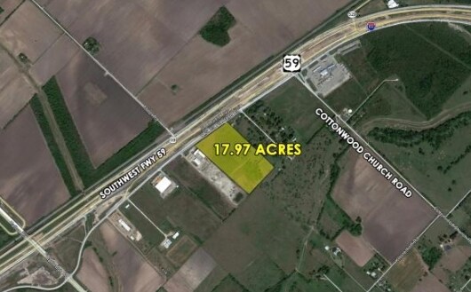
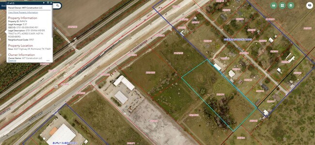
3227 Highway 59 S, Rosenberg, TX 77471
NEARBY LISTINGS FOR SALE OR LEASE
Property Detail
3227 Highway 59 S
Houston-The Woodlands-Sugar Land, TX
Emma Meyer
0701-00-008-0045-901
0701 EMMA MEYER, TRACT A (PT), ACRES 3.6586, IN CITY OF ROSENBERG
Commercialnec
Fort Bend
X
Texas
48157C0240L
a
2024
3.66 AC
2025
Southwest Outlier
675401
Houston
DEMOGRAPHICS near 3227 Highway 59 S
1 Mile
3 Mile
5 Mile
2024 Total Population
252
8,341
34,454
2029 Population
302
9,988
41,460
Pop Growth 2024-2029
+ 19.84%
+ 19.75%
+ 20.33%
Average Age
37
35
36
2024 Total Households
80
2,596
11,191
HH Growth 2024-2029
+ 21.25%
+ 20.34%
+ 20.86%
Median Household Inc
$73,124
$66,101
$62,021
Avg Household Size
3.20
3.20
3.00
2024 Avg HH Vehicles
2.00
2.00
2.00
Median Home Value
$245,833
$170,252
$187,572
Median Year Built
1989
1999
1990
Nearby Places
Map Layers
Map Styles
 Street
 Aerial
- Restaurants
- Banks
- Shops
- Fitness
- Groceries
SALE & LEASE HISTORY
LISTING DATE
SALE/LEASE

Sep 24, 2016
For Sale
Oct 20, 2021
For Sale
Mar 25, 2018
For Sale
Mar 14, 2018
For Sale
Jul 15, 2020
For Sale
Nearby Properties
Address
Land Use
TOTAL SIZE
Lot Size
Zoning
Address
Land Use
TOTAL SIZE
Lot Size
Zoning
146.35 AC
ST
Address
Land Use
TOTAL SIZE
Lot Size
Zoning
44.35 AC
YOSN
Address
Land Use
TOTAL SIZE
Lot Size
Zoning
672,112 SF
81.77 AC
YHN
Address
Land Use
TOTAL SIZE
Lot Size
Zoning
98,691 SF
29.37 AC
Address
Land Use
TOTAL SIZE
Lot Size
Zoning
672 SF
230.34 AC
YT
Address
Land Use
TOTAL SIZE
Lot Size
Zoning
54.25 AC
L
Address
Land Use
TOTAL SIZE
Lot Size
Zoning
37.08 AC
Address
Land Use
TOTAL SIZE
Lot Size
Zoning
66,896 SF
18.60 AC
ZNY
Address
Land Use
TOTAL SIZE
Lot Size
Zoning
19.57 AC
OY
Address
Land Use
TOTAL SIZE
Lot Size
Zoning
25.69 AC
Address
Land Use
TOTAL SIZE
Lot Size
Zoning
208.52 AC
OST
Address
Land Use
TOTAL SIZE
Lot Size
Zoning
194.64 AC
Address
Land Use
TOTAL SIZE
Lot Size
Zoning
145,000 SF
17.36 AC
YSNM
Address
Land Use
TOTAL SIZE
Lot Size
Zoning
8.01 AC
Address
Land Use
TOTAL SIZE
Lot Size
Zoning
11,800 SF
9.26 AC
S
Address
Land Use
TOTAL SIZE
Lot Size
Zoning
105,350 SF
11.50 AC
R
Address
Land Use
TOTAL SIZE
Lot Size
Zoning
129.15 AC
Address
Land Use
TOTAL SIZE
Lot Size
Zoning
62,521 SF
3.05 AC
XY
Address
Land Use
TOTAL SIZE
Lot Size
Zoning
85,000 SF
19.49 AC
SN
Address
Land Use
TOTAL SIZE
Lot Size
Zoning
1,064 SF
68.45 AC
OQY
Address
Land Use
TOTAL SIZE
Lot Size
Zoning
10.06 AC
ST
Address
Land Use
TOTAL SIZE
Lot Size
Zoning
1,965 SF
170.82 AC
SOYK
Address
Land Use
TOTAL SIZE
Lot Size
Zoning
51,250 SF
10.01 AC
S
Address
Land Use
TOTAL SIZE
Lot Size
Zoning
8,000 SF
6.50 AC
STN
Address
Land Use
TOTAL SIZE
Lot Size
Zoning
10,737 SF
8.26 AC
Address
Land Use
TOTAL SIZE
Lot Size
Zoning
50,000 SF
13 AC
Address
Land Use
TOTAL SIZE
Lot Size
Zoning
71.86 AC
Address
Land Use
TOTAL SIZE
Lot Size
Zoning
75.19 AC
Address
Land Use
TOTAL SIZE
Lot Size
Zoning
2.53 AC
Address
Land Use
TOTAL SIZE
Lot Size
Zoning
19.60 AC
The World's #1 Commercial Real Estate Marketplace
Connect with us
© 2025 CoStar Group
The information above has been obtained from sources believed reliable. While we do not doubt its accuracy we have not verified it and make no guarantee, warranty or representation about it. It is your responsibility to independently confirm its accuracy and completeness. Any projections, opinions, assumptions, or estimates used are for example only and do not represent the current or future performance of the property. The value of this transaction to you depends on tax and other factors which should be evaluated by your tax, financial, and legal advisors. You and your advisors should conduct a careful, independent investigation of the property to determine to your satisfaction the suitability of the property for your needs.