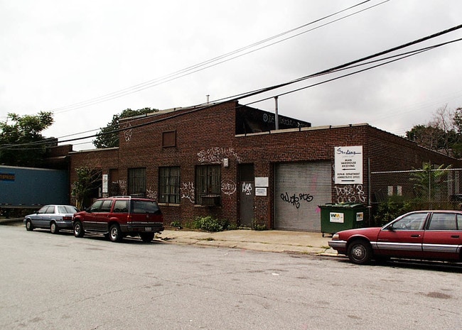
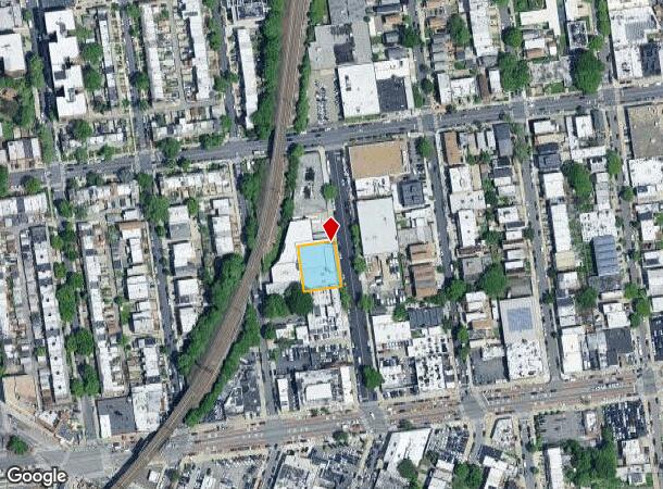
Property Record
3228 57Th St, Woodside, NY 11377
NEARBY LISTINGS FOR SALE OR LEASE
Property Detail
3228 57Th St
01158-0100
Queens
Warehouse
New York
X
100
3604970094F
0.29 AC
2024
Northwest Queens
2025
Long Island (New York)
029700
New York-Jersey City-White Plains, NY-NJ
13,400 SF
DEMOGRAPHICS near 3228 57Th St
1 mile
3 mile
5 mile
2024 Total Population
138,896
883,381
2,841,744
2029 Population
130,883
827,692
2,653,571
Pop Growth 2024-2029
(5.77%)
(6.30%)
(6.62%)
Average Age
41
40
40
2024 Total Households
53,872
349,107
1,190,790
HH Growth 2024-2029
(5.94%)
(6.39%)
(6.92%)
Median Household Inc
$71,937
$79,607
$77,052
Avg Household Size
2.50
2.40
2.30
2024 Avg HH Vehicles
1.00
1.00
.00
Median Home Value
$666,191
$745,215
$818,222
Median Year Built
1949
1955
1955
Nearby Places
Map Layers
Map Styles
 Street
 Aerial
Transit
 Traffic
 Biking
Places
Listings with unknown addresses are not visible on the map
- Restaurants
- Banks
- Shops
- Fitness
- Groceries
PUBLIC TRANSPORTATION
COMMUTER RAIL
Woodside Station (Babylon Branch - Long Island Rail Road, Far Rockaway Branch - Long Island Rail Road, Hempstead Branch - Long Island Rail Road, Long Beach Branch - Long Island Rail Road, Montauk Branch - Long Island Rail Road, Port Jefferson Branch - Long Island Rail Road, Port Washington Branch - Long Island Rail Road, Ronkonkoma Branch - Long Island Rail Road)
Drive
Walk
Distance
Woodside Station (Babylon Branch - Long Island Rail Road, Far Rockaway Branch - Long Island Rail Road, Hempstead Branch - Long Island Rail Road, Long Beach Branch - Long Island Rail Road, Montauk Branch - Long Island Rail Road, Port Jefferson Branch - Long Island Rail Road, Port Washington Branch - Long Island Rail Road, Ronkonkoma Branch - Long Island Rail Road)
3 min
15 min
0.8 mi
Hunterspoint Avenue Station (Hempstead Branch - Long Island Rail Road, Oyster Bay Branch - Long Island Rail Road)
Drive
Walk
Distance
Hunterspoint Avenue Station (Hempstead Branch - Long Island Rail Road, Oyster Bay Branch - Long Island Rail Road)
9 min
3.0 mi
AIRPORT
LaGuardia
Drive
Walk
Distance
LaGuardia
6 min
2.5 mi
John F Kennedy International
Drive
Walk
Distance
John F Kennedy International
21 min
12.7 mi
Newark Liberty International
Drive
Walk
Distance
Newark Liberty International
34 min
20.7 mi
Freight Ports
NY - Red Hook Container Terminal
Drive
Walk
Distance
NY - Red Hook Container Terminal
18 min
9.5 mi
Nearby Properties
Address
Land Use
TOTAL SIZE
Lot Size
Zoning
Address
Land Use
TOTAL SIZE
Lot Size
Zoning
97.14 AC
R7-2
Address
Land Use
TOTAL SIZE
Lot Size
Zoning
1.22 AC
R7-2
Address
Land Use
TOTAL SIZE
Lot Size
Zoning
0.92 AC
R7-2
Address
Land Use
TOTAL SIZE
Lot Size
Zoning
97.14 AC
R7-2
Address
Land Use
TOTAL SIZE
Lot Size
Zoning
4,380,201 SF
97.06 AC
R7-2
Address
Land Use
TOTAL SIZE
Lot Size
Zoning
5,519,372 SF
409.21 AC
C8-2
Address
Land Use
TOTAL SIZE
Lot Size
Zoning
2,230,742 SF
6.33 AC
R9
Address
Land Use
TOTAL SIZE
Lot Size
Zoning
988,829 SF
1.44 AC
R10
Address
Land Use
TOTAL SIZE
Lot Size
Zoning
988,829 SF
1.44 AC
R10
Address
Land Use
TOTAL SIZE
Lot Size
Zoning
988,829 SF
1.44 AC
R10
Address
Land Use
TOTAL SIZE
Lot Size
Zoning
988,829 SF
1.44 AC
R10
Address
Land Use
TOTAL SIZE
Lot Size
Zoning
988,829 SF
1.44 AC
R10
Address
Land Use
TOTAL SIZE
Lot Size
Zoning
988,829 SF
1.44 AC
R10
Address
Land Use
TOTAL SIZE
Lot Size
Zoning
988,829 SF
1.44 AC
R10
Address
Land Use
TOTAL SIZE
Lot Size
Zoning
988,829 SF
1.44 AC
R10
Address
Land Use
TOTAL SIZE
Lot Size
Zoning
988,829 SF
1.44 AC
R10
Address
Land Use
TOTAL SIZE
Lot Size
Zoning
988,829 SF
1.44 AC
R10
Address
Land Use
TOTAL SIZE
Lot Size
Zoning
988,829 SF
1.44 AC
R10
Address
Land Use
TOTAL SIZE
Lot Size
Zoning
988,829 SF
1.44 AC
R10
Address
Land Use
TOTAL SIZE
Lot Size
Zoning
988,829 SF
1.44 AC
R10
Address
Land Use
TOTAL SIZE
Lot Size
Zoning
988,829 SF
1.44 AC
R10
Address
Land Use
TOTAL SIZE
Lot Size
Zoning
988,829 SF
1.44 AC
R10
Address
Land Use
TOTAL SIZE
Lot Size
Zoning
988,829 SF
1.44 AC
R10
Address
Land Use
TOTAL SIZE
Lot Size
Zoning
988,829 SF
1.44 AC
R10
Address
Land Use
TOTAL SIZE
Lot Size
Zoning
988,829 SF
1.44 AC
R10
Address
Land Use
TOTAL SIZE
Lot Size
Zoning
988,829 SF
1.44 AC
R10
Address
Land Use
TOTAL SIZE
Lot Size
Zoning
988,829 SF
1.44 AC
R10
Address
Land Use
TOTAL SIZE
Lot Size
Zoning
988,829 SF
1.44 AC
R10
Address
Land Use
TOTAL SIZE
Lot Size
Zoning
988,829 SF
1.44 AC
R10
Address
Land Use
TOTAL SIZE
Lot Size
Zoning
988,829 SF
1.44 AC
R10
The World's #1 Commercial Real Estate Marketplace
Connect with us
© 2026 CoStar Group
The information above has been obtained from sources believed reliable. While we do not doubt its accuracy we have not verified it and make no guarantee, warranty or representation about it. It is your responsibility to independently confirm its accuracy and completeness. Any projections, opinions, assumptions, or estimates used are for example only and do not represent the current or future performance of the property. The value of this transaction to you depends on tax and other factors which should be evaluated by your tax, financial, and legal advisors. You and your advisors should conduct a careful, independent investigation of the property to determine to your satisfaction the suitability of the property for your needs.