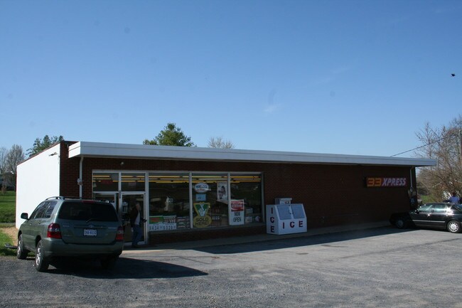
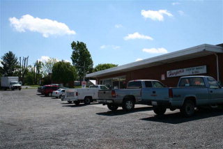
Property Record
3229 Rawley Pike, Rockingham, VA 22801


NEARBY LISTINGS FOR SALE OR LEASE
Property Detail
3229 Rawley Pike
107-A-L177
Dale Enterprise
Commercialnec
PRIOR REF: 2019-01848 01/23/2019
X
Rockingham
51165C0383D
Virginia
2025
0.36 AC
2025
Staunton & Harrisonburg
011400
Other Market Areas
3,370 SF
Harrisonburg, VA
DEMOGRAPHICS near 3229 Rawley Pike
1 Mile
3 Mile
5 Mile
2024 Total Population
2,104
24,530
66,676
2029 Population
2,151
24,345
66,485
Pop Growth 2024-2029
+ 2.23%
(0.75%)
(0.29%)
Average Age
45
35
34
2024 Total Households
786
7,953
23,050
HH Growth 2024-2029
+ 2.29%
(0.82%)
(0.30%)
Median Household Inc
$89,285
$63,693
$57,722
Avg Household Size
2.70
2.60
2.50
2024 Avg HH Vehicles
2.00
2.00
2.00
Median Home Value
$373,859
$287,516
$271,600
Median Year Built
1987
1981
1988
Nearby Places
Map Layers
Map Styles
 Street
 Aerial
- Restaurants
- Banks
- Shops
- Fitness
- Groceries
SALE & LEASE HISTORY
LISTING DATE
SALE/LEASE

Jan 17, 2017
For Sale
Feb 20, 2024
For Lease
Feb 18, 2024
For Lease
Nearby Properties
Address
Land Use
TOTAL SIZE
Lot Size
Zoning
Address
Land Use
TOTAL SIZE
Lot Size
Zoning
100,172 SF
0.79 AC
MULTI DWEL
Address
Land Use
TOTAL SIZE
Lot Size
Zoning
40,887 SF
24.09 AC
MULTI DWEL
Address
Land Use
TOTAL SIZE
Lot Size
Zoning
768 SF
62.46 AC
SINGLE FAM
Address
Land Use
TOTAL SIZE
Lot Size
Zoning
11.07 AC
RESIDENTIA
Address
Land Use
TOTAL SIZE
Lot Size
Zoning
236,916 SF
3.72 AC
MULTI DWEL
Address
Land Use
TOTAL SIZE
Lot Size
Zoning
172,594 SF
0.65 AC
MULTI DWEL
Address
Land Use
TOTAL SIZE
Lot Size
Zoning
27,572 SF
MULTI DWEL
Address
Land Use
TOTAL SIZE
Lot Size
Zoning
130,426 SF
19.11 AC
R1
Address
Land Use
TOTAL SIZE
Lot Size
Zoning
78,560 SF
3.41 AC
MULTI DWEL
Address
Land Use
TOTAL SIZE
Lot Size
Zoning
119,941 SF
10.82 AC
SINGLE FAM
Address
Land Use
TOTAL SIZE
Lot Size
Zoning
146,940 SF
32.91 AC
SINGLE FAM
Address
Land Use
TOTAL SIZE
Lot Size
Zoning
107,978 SF
20.45 AC
MULTI DWEL
Address
Land Use
TOTAL SIZE
Lot Size
Zoning
236,070 SF
2.40 AC
GENERAL IN
Address
Land Use
TOTAL SIZE
Lot Size
Zoning
28,776 SF
2.05 AC
CENTRAL BU
Address
Land Use
TOTAL SIZE
Lot Size
Zoning
206,055 SF
4.08 AC
GENERAL IN
Address
Land Use
TOTAL SIZE
Lot Size
Zoning
86,703 SF
1.42 AC
CENTRAL BU
Address
Land Use
TOTAL SIZE
Lot Size
Zoning
19,212 SF
32.58 AC
R3
Address
Land Use
TOTAL SIZE
Lot Size
Zoning
81,000 SF
20 AC
A2
Address
Land Use
TOTAL SIZE
Lot Size
Zoning
153,180 SF
19.26 AC
B1
Address
Land Use
TOTAL SIZE
Lot Size
Zoning
23,218 SF
4.21 AC
CENTRAL BU
Address
Land Use
TOTAL SIZE
Lot Size
Zoning
14,700 SF
84 AC
MULTI DWEL
Address
Land Use
TOTAL SIZE
Lot Size
Zoning
4.82 AC
B1
Address
Land Use
TOTAL SIZE
Lot Size
Zoning
7,155 SF
0.48 AC
MULTI DWEL
Address
Land Use
TOTAL SIZE
Lot Size
Zoning
3,876 SF
8.86 AC
R3
Address
Land Use
TOTAL SIZE
Lot Size
Zoning
9,000 SF
1.01 AC
CENTRAL BU
Address
Land Use
TOTAL SIZE
Lot Size
Zoning
79,968 SF
7.19 AC
RESIDENTIA
Address
Land Use
TOTAL SIZE
Lot Size
Zoning
3,441 SF
10 AC
MXU
Address
Land Use
TOTAL SIZE
Lot Size
Zoning
42,690 SF
0.60 AC
CENTRAL BU
Address
Land Use
TOTAL SIZE
Lot Size
Zoning
64,448 SF
15 AC
MULTI DWEL
Address
Land Use
TOTAL SIZE
Lot Size
Zoning
54,680 SF
16.64 AC
GENERAL BU
The World's #1 Commercial Real Estate Marketplace
Connect with us
© 2025 CoStar Group
The information above has been obtained from sources believed reliable. While we do not doubt its accuracy we have not verified it and make no guarantee, warranty or representation about it. It is your responsibility to independently confirm its accuracy and completeness. Any projections, opinions, assumptions, or estimates used are for example only and do not represent the current or future performance of the property. The value of this transaction to you depends on tax and other factors which should be evaluated by your tax, financial, and legal advisors. You and your advisors should conduct a careful, independent investigation of the property to determine to your satisfaction the suitability of the property for your needs.