Property Record
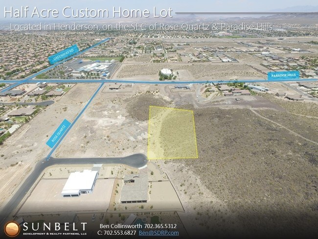
323 Wanda Rd, Henderson, NV 89002


Property Detail
323 Wanda Rd
Las Vegas-Henderson-North Las Vegas, NV
LOT 131-1B4 PM 22-30
179-32-301-022
CLARK
Vacantlandnec
Nevada
RS1
131
B and X Area of moderate flood hazard, usually the area between the limits of the 100-year and 500-year floods.
1.45 AC
2026
SE Las Vegas/Henderson
2026
Las Vegas
005362
NEARBY LISTINGS FOR SALE OR LEASE
DEMOGRAPHICS near 323 Wanda Rd
1 mile
3 mile
5 mile
2025 Total Population
8,355
52,819
108,427
2030 Population
8,710
55,697
114,545
Pop Growth 2025-2030
+ 4.25%
+ 5.45%
+ 5.64%
Average Age
37
41
41
2025 Total Households
2,470
19,433
40,732
HH Growth 2025-2030
+ 4.25%
+ 5.57%
+ 5.71%
Median Household Inc
$149,399
$95,953
$90,598
Avg Household Size
3.30
2.70
2.60
2025 Avg HH Vehicles
2.00
2.00
2.00
Median Home Value
$630,399
$458,599
$460,554
Median Year Built
2005
1998
1999
Nearby Places
Map Layers
Map Styles
 Street
 Aerial
Transit
 Traffic
 Biking
Places
Listings with unknown addresses are not visible on the map
- Restaurants
- Banks
- Shops
- Fitness
- Groceries
PUBLIC TRANSPORTATION
AIRPORT
Boulder City Municipal
Drive
Walk
Distance
Boulder City Municipal
15 min
9.7 mi
Harry Reid International
Drive
Walk
Distance
Harry Reid International
22 min
15.7 mi
Freight Ports
Port of Long Beach
Drive
Walk
Distance
Port of Long Beach
320 min
284.4 mi
SALE & LEASE HISTORY
LISTING DATE
SALE/LEASE

Sep 04, 2017
For Sale
Nearby Properties
Address
Land Use
TOTAL SIZE
Lot Size
Zoning
Address
Land Use
TOTAL SIZE
Lot Size
Zoning
Address
Land Use
TOTAL SIZE
Lot Size
Zoning
917,210 SF
60.42 AC
Address
Land Use
TOTAL SIZE
Lot Size
Zoning
46.75 AC
PS
Address
Land Use
TOTAL SIZE
Lot Size
Zoning
26.83 AC
PS
Address
Land Use
TOTAL SIZE
Lot Size
Zoning
78,760 SF
1.23 AC
Address
Land Use
TOTAL SIZE
Lot Size
Zoning
23,087 SF
71.36 AC
PS
Address
Land Use
TOTAL SIZE
Lot Size
Zoning
295,238 SF
23.49 AC
IP
Address
Land Use
TOTAL SIZE
Lot Size
Zoning
71,133 SF
7.56 AC
DP
Address
Land Use
TOTAL SIZE
Lot Size
Zoning
13.05 AC
PS
Address
Land Use
TOTAL SIZE
Lot Size
Zoning
213,472 SF
7.46 AC
Address
Land Use
TOTAL SIZE
Lot Size
Zoning
4,627 SF
7.01 AC
MC
Address
Land Use
TOTAL SIZE
Lot Size
Zoning
4,148 SF
4.38 AC
MC
Address
Land Use
TOTAL SIZE
Lot Size
Zoning
2,650 SF
11.93 AC
H:RM-16-MP
Address
Land Use
TOTAL SIZE
Lot Size
Zoning
10.01 AC
PS
Address
Land Use
TOTAL SIZE
Lot Size
Zoning
416 SF
320 AC
PS
Address
Land Use
TOTAL SIZE
Lot Size
Zoning
20 AC
PS
Address
Land Use
TOTAL SIZE
Lot Size
Zoning
510.81 AC
Address
Land Use
TOTAL SIZE
Lot Size
Zoning
41,199 SF
39.37 AC
Address
Land Use
TOTAL SIZE
Lot Size
Zoning
411,144 SF
22.69 AC
IP
Address
Land Use
TOTAL SIZE
Lot Size
Zoning
320 AC
DH
Address
Land Use
TOTAL SIZE
Lot Size
Zoning
9.13 AC
PS
Address
Land Use
TOTAL SIZE
Lot Size
Zoning
2,450 SF
4.95 AC
MC
Address
Land Use
TOTAL SIZE
Lot Size
Zoning
187,280 SF
12.32 AC
IP
Address
Land Use
TOTAL SIZE
Lot Size
Zoning
15.64 AC
PS
Address
Land Use
TOTAL SIZE
Lot Size
Zoning
96,892 SF
9.57 AC
H:MC
Address
Land Use
TOTAL SIZE
Lot Size
Zoning
2,138 SF
7.91 AC
RH20
Address
Land Use
TOTAL SIZE
Lot Size
Zoning
36,582 SF
5.83 AC
MC
Address
Land Use
TOTAL SIZE
Lot Size
Zoning
6,887 SF
5.59 AC
RH24
Address
Land Use
TOTAL SIZE
Lot Size
Zoning
77,260 SF
7.16 AC
CN
Address
Land Use
TOTAL SIZE
Lot Size
Zoning
46,162 SF
4.97 AC
MC
The World's #1 Commercial Real Estate Marketplace
Connect with us
© 2026 CoStar Group
The information above has been obtained from sources believed reliable. While we do not doubt its accuracy we have not verified it and make no guarantee, warranty or representation about it. It is your responsibility to independently confirm its accuracy and completeness. Any projections, opinions, assumptions, or estimates used are for example only and do not represent the current or future performance of the property. The value of this transaction to you depends on tax and other factors which should be evaluated by your tax, financial, and legal advisors. You and your advisors should conduct a careful, independent investigation of the property to determine to your satisfaction the suitability of the property for your needs.