Property Record
3230 Highway 64 E, Alma, AR 72921
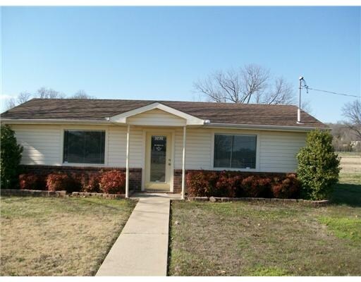

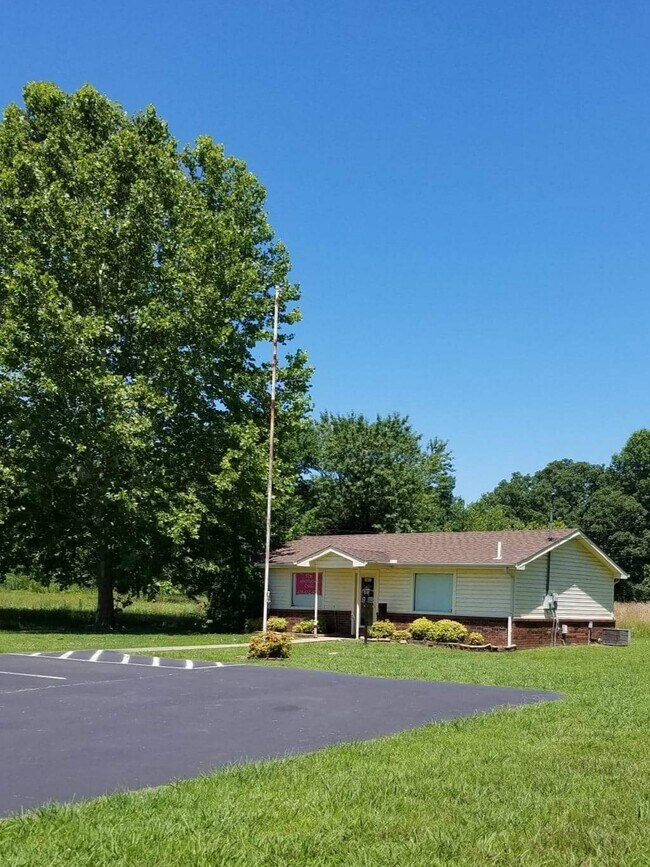
Property Detail
3230 Highway 64 E
001-01517-000-C
PT N/2 NW
Officebuilding
CRAWFORD
B and X Area of moderate flood hazard, usually the area between the limits of the 100-year and 500-year floods.
Arkansas
2025
5.04 AC
2025
Crawford County
020602
Fort Smith
8,000 SF
Fort Smith, AR-OK
NEARBY LISTINGS FOR SALE OR LEASE
DEMOGRAPHICS near 3230 Highway 64 E
1 mile
3 mile
5 mile
2025 Total Population
1,236
7,257
13,891
2030 Population
1,288
7,463
14,294
Pop Growth 2025-2030
+ 4.21%
+ 2.84%
+ 2.90%
Average Age
38
38
40
2025 Total Households
470
2,777
5,291
HH Growth 2025-2030
+ 4.26%
+ 2.84%
+ 2.89%
Median Household Inc
$44,954
$55,183
$62,210
Avg Household Size
2.60
2.60
2.60
2025 Avg HH Vehicles
2.00
2.00
2.00
Median Home Value
$172,049
$191,122
$197,398
Median Year Built
1996
1994
1992
Nearby Places
Map Layers
Map Styles
 Street
 Aerial
Layers
 Traffic
 Biking
Places
Listings with unknown addresses are not visible on the map
- Restaurants
- Banks
- Shops
- Fitness
- Groceries
PUBLIC TRANSPORTATION
AIRPORT
Fort Smith Regional
Drive
Walk
Distance
Fort Smith Regional
29 min
19.2 mi
Freight Ports
Tulsa Port of Inola
Drive
Walk
Distance
Tulsa Port of Inola
143 min
120.4 mi
SALE & LEASE HISTORY
LISTING DATE
SALE/LEASE

Aug 10, 2020
For Lease
Nearby Properties
Address
Land Use
TOTAL SIZE
Lot Size
Zoning
Address
Land Use
TOTAL SIZE
Lot Size
Zoning
39,880 SF
11.62 AC
Address
Land Use
TOTAL SIZE
Lot Size
Zoning
104,782 SF
11.42 AC
Address
Land Use
TOTAL SIZE
Lot Size
Zoning
11,477 SF
4.71 AC
Address
Land Use
TOTAL SIZE
Lot Size
Zoning
61,486 SF
5 AC
Address
Land Use
TOTAL SIZE
Lot Size
Zoning
14,400 SF
Address
Land Use
TOTAL SIZE
Lot Size
Zoning
34,266 SF
2.82 AC
Address
Land Use
TOTAL SIZE
Lot Size
Zoning
48,682 SF
5.70 AC
Address
Land Use
TOTAL SIZE
Lot Size
Zoning
42,770 SF
7.16 AC
Address
Land Use
TOTAL SIZE
Lot Size
Zoning
2,960 SF
47.69 AC
Address
Land Use
TOTAL SIZE
Lot Size
Zoning
13,696 SF
0.84 AC
Address
Land Use
TOTAL SIZE
Lot Size
Zoning
10,335 SF
9.66 AC
Address
Land Use
TOTAL SIZE
Lot Size
Zoning
20,656 SF
2.97 AC
Address
Land Use
TOTAL SIZE
Lot Size
Zoning
26,510 SF
2.89 AC
Address
Land Use
TOTAL SIZE
Lot Size
Zoning
61,350 SF
3.85 AC
Address
Land Use
TOTAL SIZE
Lot Size
Zoning
20,460 SF
5.68 AC
Address
Land Use
TOTAL SIZE
Lot Size
Zoning
9,830 SF
0.73 AC
Address
Land Use
TOTAL SIZE
Lot Size
Zoning
22,840 SF
4.23 AC
Address
Land Use
TOTAL SIZE
Lot Size
Zoning
10,374 SF
3 AC
Address
Land Use
TOTAL SIZE
Lot Size
Zoning
27,122 SF
2.62 AC
Address
Land Use
TOTAL SIZE
Lot Size
Zoning
4,116 SF
34.48 AC
Address
Land Use
TOTAL SIZE
Lot Size
Zoning
14,528 SF
5.88 AC
Address
Land Use
TOTAL SIZE
Lot Size
Zoning
34,578 SF
0.91 AC
Address
Land Use
TOTAL SIZE
Lot Size
Zoning
7,955 SF
8 AC
Address
Land Use
TOTAL SIZE
Lot Size
Zoning
29,396 SF
1.46 AC
Address
Land Use
TOTAL SIZE
Lot Size
Zoning
4,022 SF
2.02 AC
Address
Land Use
TOTAL SIZE
Lot Size
Zoning
19,680 SF
2.15 AC
Address
Land Use
TOTAL SIZE
Lot Size
Zoning
3,940 SF
1.83 AC
Address
Land Use
TOTAL SIZE
Lot Size
Zoning
10,870 SF
1.15 AC
Address
Land Use
TOTAL SIZE
Lot Size
Zoning
12,396 SF
105.32 AC
Address
Land Use
TOTAL SIZE
Lot Size
Zoning
7,182 SF
2.28 AC
The World's #1 Commercial Real Estate Marketplace
Connect with us
© 2026 CoStar Group
The information above has been obtained from sources believed reliable. While we do not doubt its accuracy we have not verified it and make no guarantee, warranty or representation about it. It is your responsibility to independently confirm its accuracy and completeness. Any projections, opinions, assumptions, or estimates used are for example only and do not represent the current or future performance of the property. The value of this transaction to you depends on tax and other factors which should be evaluated by your tax, financial, and legal advisors. You and your advisors should conduct a careful, independent investigation of the property to determine to your satisfaction the suitability of the property for your needs.