Property Record
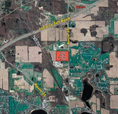
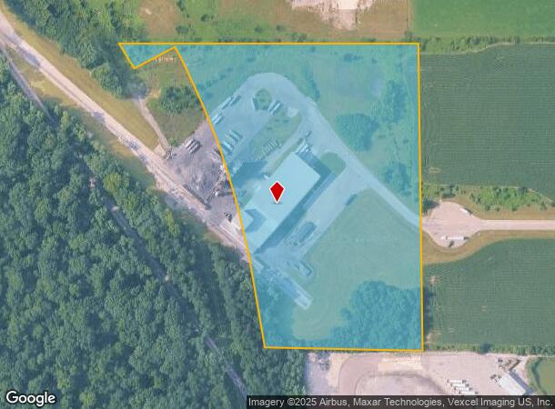
3230 N State Road 39, La Porte, IN 46350
NEARBY LISTINGS FOR SALE OR LEASE
Property Detail
3230 N State Road 39
46-06-15-400-018.000-042
05-06-15-400-018 MID PT W1/2 SE1/4 E OF RR S15 T37 R3 14.00 AC
Warehouse
La Porte
X
Indiana
18091C0165D
14 AC
2023
South Bend/Elkhart
2024
Other Market Areas
042500
Michigan City-La Porte, IN
39,780 SF
DEMOGRAPHICS near 3230 N State Road 39
1 Mile
3 Mile
5 Mile
2024 Total Population
629
10,242
36,034
2029 Population
630
10,180
35,552
Pop Growth 2024-2029
+ 0.16%
(0.61%)
(1.34%)
Average Age
43
41
41
2024 Total Households
240
4,005
14,287
HH Growth 2024-2029
0.00%
(0.70%)
(1.53%)
Median Household Inc
$108,125
$69,465
$63,628
Avg Household Size
2.60
2.50
2.40
2024 Avg HH Vehicles
2.00
2.00
2.00
Median Home Value
$252,336
$223,069
$182,047
Median Year Built
1985
1974
1964
Nearby Places
Map Layers
Map Styles
 Street
 Aerial
- Restaurants
- Banks
- Shops
- Fitness
- Groceries
PUBLIC TRANSPORTATION
AIRPORT
South Bend International
DRIVE
WALK
Distance
South Bend International
45 min
30.1 mi
Freight Ports
Port Milwaukee
DRIVE
WALK
Distance
Port Milwaukee
185 min
151.4 mi
SALE & LEASE HISTORY
LISTING DATE
SALE/LEASE

Sep 24, 2016
For Sale
Nearby Properties
Address
Land Use
TOTAL SIZE
Lot Size
Zoning
Address
Land Use
TOTAL SIZE
Lot Size
Zoning
225,592 SF
3.72 AC
Address
Land Use
TOTAL SIZE
Lot Size
Zoning
294,600 SF
22.86 AC
Address
Land Use
TOTAL SIZE
Lot Size
Zoning
289,954 SF
15.78 AC
Address
Land Use
TOTAL SIZE
Lot Size
Zoning
237,466 SF
19.13 AC
Address
Land Use
TOTAL SIZE
Lot Size
Zoning
603,796 SF
18.96 AC
Address
Land Use
TOTAL SIZE
Lot Size
Zoning
150,364 SF
14.26 AC
Address
Land Use
TOTAL SIZE
Lot Size
Zoning
56,034 SF
3.04 AC
Address
Land Use
TOTAL SIZE
Lot Size
Zoning
19,230 SF
2.32 AC
Address
Land Use
TOTAL SIZE
Lot Size
Zoning
28,986 SF
32.14 AC
Address
Land Use
TOTAL SIZE
Lot Size
Zoning
164,786 SF
2 AC
Address
Land Use
TOTAL SIZE
Lot Size
Zoning
6,569 SF
2.38 AC
Address
Land Use
TOTAL SIZE
Lot Size
Zoning
45,375 SF
4.67 AC
Address
Land Use
TOTAL SIZE
Lot Size
Zoning
10,506 SF
2.23 AC
Address
Land Use
TOTAL SIZE
Lot Size
Zoning
50,266 SF
10 AC
Address
Land Use
TOTAL SIZE
Lot Size
Zoning
13,150 SF
4.69 AC
Address
Land Use
TOTAL SIZE
Lot Size
Zoning
30,477 SF
1.68 AC
Address
Land Use
TOTAL SIZE
Lot Size
Zoning
143,610 SF
7.50 AC
Address
Land Use
TOTAL SIZE
Lot Size
Zoning
35,922 SF
1.28 AC
Address
Land Use
TOTAL SIZE
Lot Size
Zoning
12,460 SF
65.01 AC
Address
Land Use
TOTAL SIZE
Lot Size
Zoning
107,301 SF
4.93 AC
Address
Land Use
TOTAL SIZE
Lot Size
Zoning
60,088 SF
9.13 AC
Address
Land Use
TOTAL SIZE
Lot Size
Zoning
189,679 SF
8.93 AC
Address
Land Use
TOTAL SIZE
Lot Size
Zoning
13,614 SF
20 AC
Address
Land Use
TOTAL SIZE
Lot Size
Zoning
18,375 SF
21.51 AC
Address
Land Use
TOTAL SIZE
Lot Size
Zoning
87,373 SF
5.79 AC
Address
Land Use
TOTAL SIZE
Lot Size
Zoning
228,829 SF
4.95 AC
Address
Land Use
TOTAL SIZE
Lot Size
Zoning
3,829 SF
0.59 AC
Address
Land Use
TOTAL SIZE
Lot Size
Zoning
260,480 SF
6.88 AC
Address
Land Use
TOTAL SIZE
Lot Size
Zoning
31,782 SF
1.70 AC
The World's #1 Commercial Real Estate Marketplace
Connect with us
© 2025 CoStar Group
The information above has been obtained from sources believed reliable. While we do not doubt its accuracy we have not verified it and make no guarantee, warranty or representation about it. It is your responsibility to independently confirm its accuracy and completeness. Any projections, opinions, assumptions, or estimates used are for example only and do not represent the current or future performance of the property. The value of this transaction to you depends on tax and other factors which should be evaluated by your tax, financial, and legal advisors. You and your advisors should conduct a careful, independent investigation of the property to determine to your satisfaction the suitability of the property for your needs.