Property Record
3230 Perkins Rd, Augusta, GA 30906
NEARBY LISTINGS FOR SALE OR LEASE
-
-
View all Augusta listings for sale on LoopNet.com
Property Detail
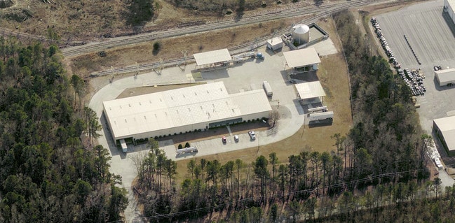
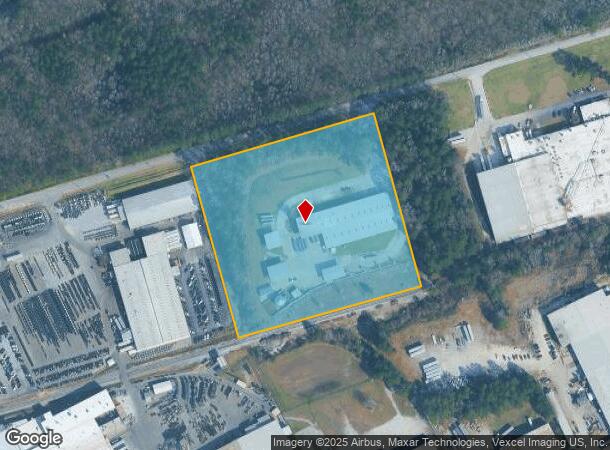
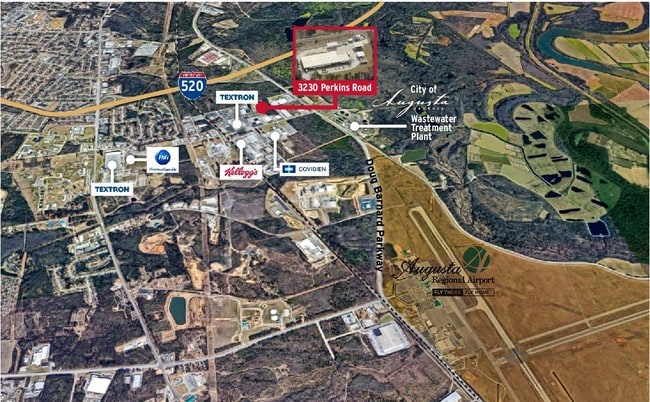
3230 Perkins Rd
1240005000
3230 PERKINS RD
Commercialacreage
Richmond
X
Georgia
13245C0140H
8.21 AC
2025
South Richmond County
2025
Augusta/Richmond County
010602
Augusta-Richmond County, GA-SC
28,997 SF
DEMOGRAPHICS near 3230 Perkins Rd
1 Mile
3 Mile
5 Mile
2024 Total Population
1,425
16,943
68,349
2029 Population
1,410
16,783
68,215
Pop Growth 2024-2029
(1.05%)
(0.94%)
(0.20%)
Average Age
36
37
38
2024 Total Households
311
6,094
26,549
HH Growth 2024-2029
(2.25%)
(0.97%)
(0.02%)
Median Household Inc
$26,591
$34,784
$34,160
Avg Household Size
2.70
2.50
2.40
2024 Avg HH Vehicles
2.00
2.00
2.00
Median Home Value
$60,077
$77,053
$91,950
Median Year Built
1973
1966
1970
Nearby Places
Map Layers
Map Styles
 Street
 Aerial
- Restaurants
- Banks
- Shops
- Fitness
- Groceries
PUBLIC TRANSPORTATION
AIRPORT
Augusta Regional at Bush Field
DRIVE
WALK
Distance
Augusta Regional at Bush Field
9 min
2.6 mi
Freight Ports
Georgia Ports - Savannah
DRIVE
WALK
Distance
Georgia Ports - Savannah
149 min
111.9 mi
SALE & LEASE HISTORY
LISTING DATE
SALE/LEASE

Nov 15, 2019
For Sale
Nearby Properties
Address
Land Use
TOTAL SIZE
Lot Size
Zoning
Address
Land Use
TOTAL SIZE
Lot Size
Zoning
297,455 SF
45.93 AC
A
Address
Land Use
TOTAL SIZE
Lot Size
Zoning
78,943 SF
1,319.60 AC
HI
Address
Land Use
TOTAL SIZE
Lot Size
Zoning
39,200 SF
310.85 AC
A_R-1A
Address
Land Use
TOTAL SIZE
Lot Size
Zoning
99,046 SF
29.96 AC
R-1A
Address
Land Use
TOTAL SIZE
Lot Size
Zoning
449,636 SF
31.57 AC
Address
Land Use
TOTAL SIZE
Lot Size
Zoning
225,664 SF
57.13 AC
LI
Address
Land Use
TOTAL SIZE
Lot Size
Zoning
552,852 SF
215.52 AC
A_HI
Address
Land Use
TOTAL SIZE
Lot Size
Zoning
4,507 SF
56.06 AC
HI
Address
Land Use
TOTAL SIZE
Lot Size
Zoning
14,850 SF
132.49 AC
A,R
Address
Land Use
TOTAL SIZE
Lot Size
Zoning
18,000 SF
27.80 AC
B-2
Address
Land Use
TOTAL SIZE
Lot Size
Zoning
403,560 SF
27.99 AC
HI_LI
Address
Land Use
TOTAL SIZE
Lot Size
Zoning
16,790 SF
22.07 AC
B-2
Address
Land Use
TOTAL SIZE
Lot Size
Zoning
70,251 SF
9.17 AC
R-1B
Address
Land Use
TOTAL SIZE
Lot Size
Zoning
41,937 SF
37.84 AC
HI
Address
Land Use
TOTAL SIZE
Lot Size
Zoning
136,260 SF
14.42 AC
LI_R-1
Address
Land Use
TOTAL SIZE
Lot Size
Zoning
57,408 SF
7.20 AC
R-3B
Address
Land Use
TOTAL SIZE
Lot Size
Zoning
403,560 SF
27.99 AC
HI_LI
Address
Land Use
TOTAL SIZE
Lot Size
Zoning
4,356 SF
52.76 AC
A_R-MH_B-2
Address
Land Use
TOTAL SIZE
Lot Size
Zoning
298,532 SF
20.39 AC
HI
Address
Land Use
TOTAL SIZE
Lot Size
Zoning
78,454 SF
10.63 AC
B-2
Address
Land Use
TOTAL SIZE
Lot Size
Zoning
443,388 SF
38.88 AC
HI
Address
Land Use
TOTAL SIZE
Lot Size
Zoning
62,379 SF
73.78 AC
HI
Address
Land Use
TOTAL SIZE
Lot Size
Zoning
96,585 SF
9.42 AC
LI
Address
Land Use
TOTAL SIZE
Lot Size
Zoning
166,400 SF
77.09 AC
HI_A
Address
Land Use
TOTAL SIZE
Lot Size
Zoning
305,990 SF
28.25 AC
HI
Address
Land Use
TOTAL SIZE
Lot Size
Zoning
81,529 SF
6.59 AC
B-2
Address
Land Use
TOTAL SIZE
Lot Size
Zoning
126,323 SF
5.75 AC
HI
Address
Land Use
TOTAL SIZE
Lot Size
Zoning
33,024 SF
10.64 AC
R-3B
Address
Land Use
TOTAL SIZE
Lot Size
Zoning
127,476 SF
10.19 AC
HI
Address
Land Use
TOTAL SIZE
Lot Size
Zoning
3,102 SF
7.34 AC
HI
The World's #1 Commercial Real Estate Marketplace
Connect with us
© 2026 CoStar Group
The information above has been obtained from sources believed reliable. While we do not doubt its accuracy we have not verified it and make no guarantee, warranty or representation about it. It is your responsibility to independently confirm its accuracy and completeness. Any projections, opinions, assumptions, or estimates used are for example only and do not represent the current or future performance of the property. The value of this transaction to you depends on tax and other factors which should be evaluated by your tax, financial, and legal advisors. You and your advisors should conduct a careful, independent investigation of the property to determine to your satisfaction the suitability of the property for your needs.