Property Record
32301 Singletary Rd, Myakka City, FL 34251

NEARBY LISTINGS FOR SALE OR LEASE
-
-
View all Myakka City listings for sale on LoopNet.com
Property Detail
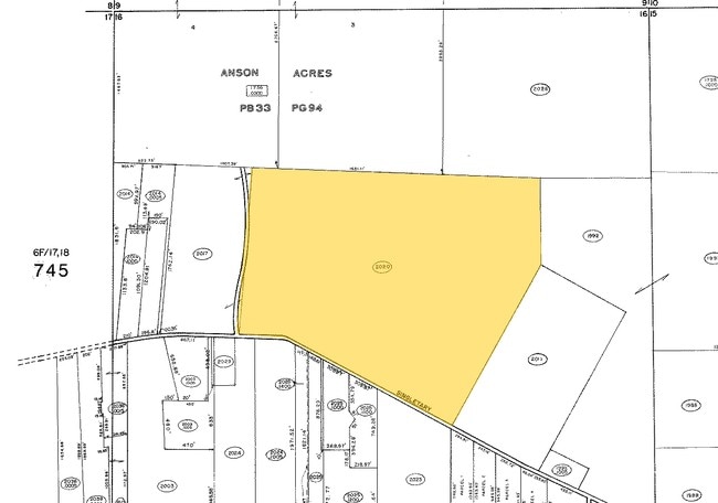
32301 Singletary Rd
2020-0000-6
Acreage & Unrec
Agriculturalland
BEG AT SW COR OF SEC 16, THENCE N ALG THE W LN OF SD SEC 16, A DIST OF 1970.68 FT TO THE CENTER OF A CTY RD, TH N 80 DEG 03 MIN 30 SEC E ALG THE CENTER OF SD CTY RD A DIST OF 456 FT
A
Manatee
12081C0455E
Florida
2023
131.02 AC
2025
Manatee Outlying
002010
Tampa/St Petersburg
3,807 SF
North Port-Sarasota-Bradenton, FL
DEMOGRAPHICS near 32301 Singletary Rd
1 Mile
3 Mile
5 Mile
2024 Total Population
114
1,128
3,143
2029 Population
131
1,291
3,576
Pop Growth 2024-2029
+ 14.91%
+ 14.45%
+ 13.78%
Average Age
41
41
41
2024 Total Households
39
389
1,083
HH Growth 2024-2029
+ 15.38%
+ 13.37%
+ 12.93%
Median Household Inc
$91,071
$93,166
$95,125
Avg Household Size
2.80
2.80
2.80
2024 Avg HH Vehicles
3.00
3.00
2.00
Median Home Value
$466,666
$445,161
$450,815
Median Year Built
1995
1995
1994
Nearby Places
Map Layers
Map Styles
 Street
 Aerial
- Restaurants
- Banks
- Shops
- Fitness
- Groceries
PUBLIC TRANSPORTATION
AIRPORT
Sarasota/Bradenton International
DRIVE
WALK
Distance
Sarasota/Bradenton International
51 min
30.0 mi
Freight Ports
Port Manatee
DRIVE
WALK
Distance
Port Manatee
56 min
35.9 mi
Nearby Properties
Address
Land Use
TOTAL SIZE
Lot Size
Zoning
Address
Land Use
TOTAL SIZE
Lot Size
Zoning
1,832 SF
359.78 AC
A GENERAL
Address
Land Use
TOTAL SIZE
Lot Size
Zoning
191 AC
A GENERAL
Address
Land Use
TOTAL SIZE
Lot Size
Zoning
12,272 SF
28 AC
OUR
Address
Land Use
TOTAL SIZE
Lot Size
Zoning
5,713 SF
22.41 AC
A GENERAL
Address
Land Use
TOTAL SIZE
Lot Size
Zoning
326,820 SF
242.72 AC
A GENERAL
Address
Land Use
TOTAL SIZE
Lot Size
Zoning
4,756 SF
36.32 AC
A GENERAL
Address
Land Use
TOTAL SIZE
Lot Size
Zoning
9,100 SF
1.20 AC
PD-C
Address
Land Use
TOTAL SIZE
Lot Size
Zoning
12,000 SF
2,213.80 AC
A GENERAL
Address
Land Use
TOTAL SIZE
Lot Size
Zoning
130 AC
A GENERAL
Address
Land Use
TOTAL SIZE
Lot Size
Zoning
6,900 SF
30.40 AC
A GENERAL
Address
Land Use
TOTAL SIZE
Lot Size
Zoning
2,377 SF
39.80 AC
A GENERAL
Address
Land Use
TOTAL SIZE
Lot Size
Zoning
3,830 SF
26.58 AC
A-1 SUBURB
Address
Land Use
TOTAL SIZE
Lot Size
Zoning
46.09 AC
A GENERAL
Address
Land Use
TOTAL SIZE
Lot Size
Zoning
6,209 SF
5 AC
A GENERAL
Address
Land Use
TOTAL SIZE
Lot Size
Zoning
6,554 SF
5 AC
A GENERAL
Address
Land Use
TOTAL SIZE
Lot Size
Zoning
8,000 SF
38.12 AC
A GENERAL
Address
Land Use
TOTAL SIZE
Lot Size
Zoning
40.59 AC
A GENERAL
Address
Land Use
TOTAL SIZE
Lot Size
Zoning
1,372 SF
25.20 AC
A GENERAL
Address
Land Use
TOTAL SIZE
Lot Size
Zoning
4,389 SF
5.01 AC
A GENERAL
Address
Land Use
TOTAL SIZE
Lot Size
Zoning
80 AC
GU
Address
Land Use
TOTAL SIZE
Lot Size
Zoning
7,092 SF
78 AC
A GENERAL
Address
Land Use
TOTAL SIZE
Lot Size
Zoning
3,977 SF
5 AC
A GENERAL
Address
Land Use
TOTAL SIZE
Lot Size
Zoning
4,392 SF
100.35 AC
A GENERAL
Address
Land Use
TOTAL SIZE
Lot Size
Zoning
3,664 SF
40.76 AC
OUR
Address
Land Use
TOTAL SIZE
Lot Size
Zoning
3,435 SF
63.41 AC
A GENERAL
Address
Land Use
TOTAL SIZE
Lot Size
Zoning
4,856 SF
30.03 AC
A GENERAL
Address
Land Use
TOTAL SIZE
Lot Size
Zoning
22.83 AC
A GENERAL
Address
Land Use
TOTAL SIZE
Lot Size
Zoning
2,282 SF
9.84 AC
A-1 SUBURB
Address
Land Use
TOTAL SIZE
Lot Size
Zoning
3,628 SF
5.01 AC
A GENERAL
The World's #1 Commercial Real Estate Marketplace
Connect with us
© 2026 CoStar Group
The information above has been obtained from sources believed reliable. While we do not doubt its accuracy we have not verified it and make no guarantee, warranty or representation about it. It is your responsibility to independently confirm its accuracy and completeness. Any projections, opinions, assumptions, or estimates used are for example only and do not represent the current or future performance of the property. The value of this transaction to you depends on tax and other factors which should be evaluated by your tax, financial, and legal advisors. You and your advisors should conduct a careful, independent investigation of the property to determine to your satisfaction the suitability of the property for your needs.