Property Record
3232 E 40Th St, Minneapolis, MN 55406
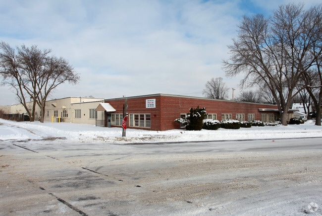

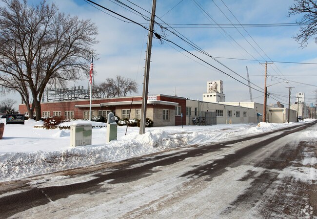
Property Detail
3232 E 40Th St
07-028-23-22-0050
LOT 013 BLOCK 029 A PALMERS ADDN TO MPLS LOTS 8 TO 19 INCL AND THE SELY 1/2 OF LOT 7 S 201X392X170X481
Industrialgeneral
Hennepin
I1
Minnesota
B and X Area of moderate flood hazard, usually the area between the limits of the 100-year and 500-year floods.
13
2024
1.75 AC
2024
Minneapolis
110400
Minneapolis/St Paul
48,286 SF
Minneapolis-St. Paul-Bloomington, MN-WI
NEARBY LISTINGS FOR SALE OR LEASE
DEMOGRAPHICS near 3232 E 40Th St
1 mile
3 mile
5 mile
2025 Total Population
22,284
199,284
471,725
2030 Population
22,305
199,467
473,300
Pop Growth 2025-2030
+ 0.09%
+ 0.09%
+ 0.33%
Average Age
41
37
38
2025 Total Households
9,889
81,092
211,302
HH Growth 2025-2030
+ 0.07%
+ 0.02%
+ 0.41%
Median Household Inc
$94,833
$79,452
$81,365
Avg Household Size
2.10
2.20
2.10
2025 Avg HH Vehicles
2.00
1.00
1.00
Median Home Value
$341,729
$367,657
$380,343
Median Year Built
1947
1948
1954
Nearby Places
Map Layers
Map Styles
 Street
 Aerial
Layers
 Traffic
 Biking
Places
Listings with unknown addresses are not visible on the map
- Restaurants
- Banks
- Shops
- Fitness
- Groceries
PUBLIC TRANSPORTATION
TRANSIT/SUBWAY
38Th Street Station (Hiawatha Line - Minneapolis-Saint Paul Metro Transit Light Rail)
Drive
Walk
Distance
38Th Street Station (Hiawatha Line - Minneapolis-Saint Paul Metro Transit Light Rail)
1 min
7 min
0.4 mi
46Th Street Station (Hiawatha Line - Minneapolis-Saint Paul Metro Transit Light Rail)
Drive
Walk
Distance
46Th Street Station (Hiawatha Line - Minneapolis-Saint Paul Metro Transit Light Rail)
2 min
17 min
0.9 mi
COMMUTER RAIL
Target Field Station (Northstar Corridor - Northstar Commuter Rail)
Drive
Walk
Distance
Target Field Station (Northstar Corridor - Northstar Commuter Rail)
12 min
4.9 mi
St. Paul-Minneapolis (Empire Builder - Amtrak)
Drive
Walk
Distance
St. Paul-Minneapolis (Empire Builder - Amtrak)
19 min
9.3 mi
AIRPORT
Minneapolis-St Paul International/Wold-Chamberlain
Drive
Walk
Distance
Minneapolis-St Paul International/Wold-Chamberlain
14 min
6.6 mi
Freight Ports
Port Milwaukee
Drive
Walk
Distance
Port Milwaukee
378 min
337.0 mi
Nearby Properties
Address
Land Use
TOTAL SIZE
Lot Size
Zoning
Address
Land Use
TOTAL SIZE
Lot Size
Zoning
141,277 SF
44.78 AC
Address
Land Use
TOTAL SIZE
Lot Size
Zoning
84,316 SF
40.83 AC
Address
Land Use
TOTAL SIZE
Lot Size
Zoning
504,049 SF
75.43 AC
Address
Land Use
TOTAL SIZE
Lot Size
Zoning
176,108 SF
27.45 AC
Address
Land Use
TOTAL SIZE
Lot Size
Zoning
577,656 SF
2.92 AC
C3A
Address
Land Use
TOTAL SIZE
Lot Size
Zoning
2.65 AC
Address
Land Use
TOTAL SIZE
Lot Size
Zoning
267,530 SF
28.60 AC
Address
Land Use
TOTAL SIZE
Lot Size
Zoning
546,882 SF
2.64 AC
R6
Address
Land Use
TOTAL SIZE
Lot Size
Zoning
344,458 SF
1.64 AC
C3A
Address
Land Use
TOTAL SIZE
Lot Size
Zoning
423,037 SF
0.28 AC
C3A
Address
Land Use
TOTAL SIZE
Lot Size
Zoning
3,200 SF
0.14 AC
Address
Land Use
TOTAL SIZE
Lot Size
Zoning
518,750 SF
3.58 AC
Address
Land Use
TOTAL SIZE
Lot Size
Zoning
291,264 SF
1.61 AC
C3A
Address
Land Use
TOTAL SIZE
Lot Size
Zoning
245,477 SF
1.32 AC
C3A
Address
Land Use
TOTAL SIZE
Lot Size
Zoning
200,892 SF
3.60 AC
Address
Land Use
TOTAL SIZE
Lot Size
Zoning
313,892 SF
2.03 AC
R5
Address
Land Use
TOTAL SIZE
Lot Size
Zoning
251,619 SF
1.20 AC
Address
Land Use
TOTAL SIZE
Lot Size
Zoning
Address
Land Use
TOTAL SIZE
Lot Size
Zoning
318,765 SF
3.58 AC
Address
Land Use
TOTAL SIZE
Lot Size
Zoning
261,098 SF
24.12 AC
Address
Land Use
TOTAL SIZE
Lot Size
Zoning
429,720 SF
6.02 AC
Address
Land Use
TOTAL SIZE
Lot Size
Zoning
Address
Land Use
TOTAL SIZE
Lot Size
Zoning
31,694 SF
4.24 AC
I1
Address
Land Use
TOTAL SIZE
Lot Size
Zoning
310,391 SF
1.77 AC
Address
Land Use
TOTAL SIZE
Lot Size
Zoning
211,656 SF
4.38 AC
Address
Land Use
TOTAL SIZE
Lot Size
Zoning
568,301 SF
0.78 AC
C3A
Address
Land Use
TOTAL SIZE
Lot Size
Zoning
Address
Land Use
TOTAL SIZE
Lot Size
Zoning
354,346 SF
1.72 AC
R6
Address
Land Use
TOTAL SIZE
Lot Size
Zoning
179,243 SF
1.05 AC
C2
Address
Land Use
TOTAL SIZE
Lot Size
Zoning
158,848 SF
1.04 AC
R6
The World's #1 Commercial Real Estate Marketplace
Connect with us
© 2026 CoStar Group
The information above has been obtained from sources believed reliable. While we do not doubt its accuracy we have not verified it and make no guarantee, warranty or representation about it. It is your responsibility to independently confirm its accuracy and completeness. Any projections, opinions, assumptions, or estimates used are for example only and do not represent the current or future performance of the property. The value of this transaction to you depends on tax and other factors which should be evaluated by your tax, financial, and legal advisors. You and your advisors should conduct a careful, independent investigation of the property to determine to your satisfaction the suitability of the property for your needs.