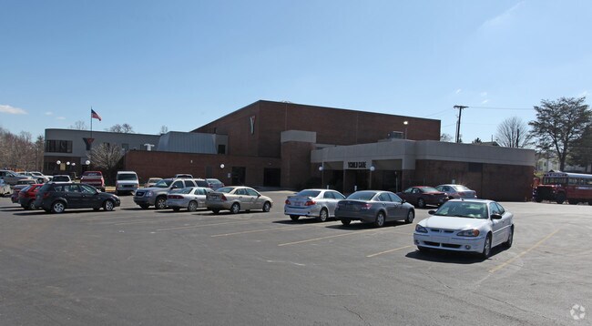
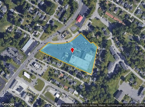
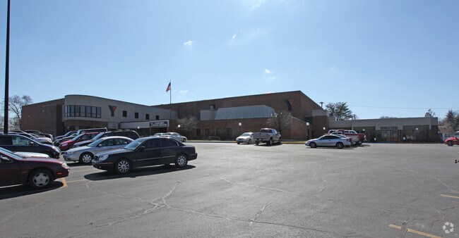
Property Record
3232 Megan Neyer Way, Ashland, KY 41102
NEARBY LISTINGS FOR SALE OR LEASE
Property Detail
3232 Megan Neyer Way
Huntington-Ashland, WV-KY-OH
Midland Heights Subdivision
023-05-11-001.00
6 ACRES
Gymhealthspa
Boyd
X
Kentucky
21019C0058D
6 AC
0
Greater Ashland
2024
Huntington/Ashland
030600
DEMOGRAPHICS near 3232 Megan Neyer Way
1 Mile
3 Mile
5 Mile
2024 Total Population
6,775
30,808
55,481
2029 Population
6,696
30,522
54,592
Pop Growth 2024-2029
(1.17%)
(0.93%)
(1.60%)
Average Age
42
42
42
2024 Total Households
2,875
12,871
22,936
HH Growth 2024-2029
(1.11%)
(0.89%)
(1.54%)
Median Household Inc
$50,833
$51,340
$52,061
Avg Household Size
2.30
2.30
2.30
2024 Avg HH Vehicles
2.00
2.00
2.00
Median Home Value
$122,659
$119,955
$121,314
Median Year Built
1965
1966
1967
Nearby Places
Map Layers
Map Styles
 Street
 Aerial
- Restaurants
- Banks
- Shops
- Fitness
- Groceries
PUBLIC TRANSPORTATION
COMMUTER RAIL
Ashland Amtrak Station (Cardinal - Amtrak)
DRIVE
WALK
Distance
Ashland Amtrak Station (Cardinal - Amtrak)
4 min
2.3 mi
AIRPORT
Tri-State/Milton J Ferguson Field
DRIVE
WALK
Distance
Tri-State/Milton J Ferguson Field
25 min
13.4 mi
Freight Ports
Port of Toledo
DRIVE
WALK
Distance
Port of Toledo
335 min
259.3 mi
Nearby Properties
Address
Land Use
TOTAL SIZE
Lot Size
Zoning
Address
Land Use
TOTAL SIZE
Lot Size
Zoning
6.96 AC
Z02
Address
Land Use
TOTAL SIZE
Lot Size
Zoning
36.49 AC
OTHER
Address
Land Use
TOTAL SIZE
Lot Size
Zoning
29.92 AC
Z02
Address
Land Use
TOTAL SIZE
Lot Size
Zoning
3,514 SF
21.96 AC
Z02
Address
Land Use
TOTAL SIZE
Lot Size
Zoning
0.99 AC
Z02
Address
Land Use
TOTAL SIZE
Lot Size
Zoning
1.94 AC
Z03
Address
Land Use
TOTAL SIZE
Lot Size
Zoning
16.29 AC
COMMERCIAL
Address
Land Use
TOTAL SIZE
Lot Size
Zoning
116,640 SF
0.97 AC
COMMERCIAL
Address
Land Use
TOTAL SIZE
Lot Size
Zoning
4.47 AC
COMMERCIAL
Address
Land Use
TOTAL SIZE
Lot Size
Zoning
28.87 AC
COMMERCIAL
Address
Land Use
TOTAL SIZE
Lot Size
Zoning
91,786 SF
2.93 AC
Address
Land Use
TOTAL SIZE
Lot Size
Zoning
0.73 AC
Z02
Address
Land Use
TOTAL SIZE
Lot Size
Zoning
0.38 AC
COMMERCIAL
Address
Land Use
TOTAL SIZE
Lot Size
Zoning
1.67 AC
RESIDENTIA
Address
Land Use
TOTAL SIZE
Lot Size
Zoning
1.63 AC
COMMERCIAL
Address
Land Use
TOTAL SIZE
Lot Size
Zoning
1.95 AC
COMMERCIAL
Address
Land Use
TOTAL SIZE
Lot Size
Zoning
22 AC
OTHER
Address
Land Use
TOTAL SIZE
Lot Size
Zoning
4.30 AC
COMMERCIAL
Address
Land Use
TOTAL SIZE
Lot Size
Zoning
22,592 SF
43.50 AC
OTHER
Address
Land Use
TOTAL SIZE
Lot Size
Zoning
47,107 SF
4.67 AC
Address
Land Use
TOTAL SIZE
Lot Size
Zoning
1.46 AC
COMMERCIAL
Address
Land Use
TOTAL SIZE
Lot Size
Zoning
Address
Land Use
TOTAL SIZE
Lot Size
Zoning
0.21 AC
Z02
Address
Land Use
TOTAL SIZE
Lot Size
Zoning
3.50 AC
Z02
Address
Land Use
TOTAL SIZE
Lot Size
Zoning
1,920 SF
33.30 AC
Z03
Address
Land Use
TOTAL SIZE
Lot Size
Zoning
2.50 AC
Address
Land Use
TOTAL SIZE
Lot Size
Zoning
0.57 AC
COMMERCIAL
Address
Land Use
TOTAL SIZE
Lot Size
Zoning
33,980 SF
2.03 AC
COMMERCIAL
Address
Land Use
TOTAL SIZE
Lot Size
Zoning
16,632 SF
1.07 AC
COMMERCIAL
Address
Land Use
TOTAL SIZE
Lot Size
Zoning
54.65 AC
The World's #1 Commercial Real Estate Marketplace
Connect with us
© 2026 CoStar Group
The information above has been obtained from sources believed reliable. While we do not doubt its accuracy we have not verified it and make no guarantee, warranty or representation about it. It is your responsibility to independently confirm its accuracy and completeness. Any projections, opinions, assumptions, or estimates used are for example only and do not represent the current or future performance of the property. The value of this transaction to you depends on tax and other factors which should be evaluated by your tax, financial, and legal advisors. You and your advisors should conduct a careful, independent investigation of the property to determine to your satisfaction the suitability of the property for your needs.