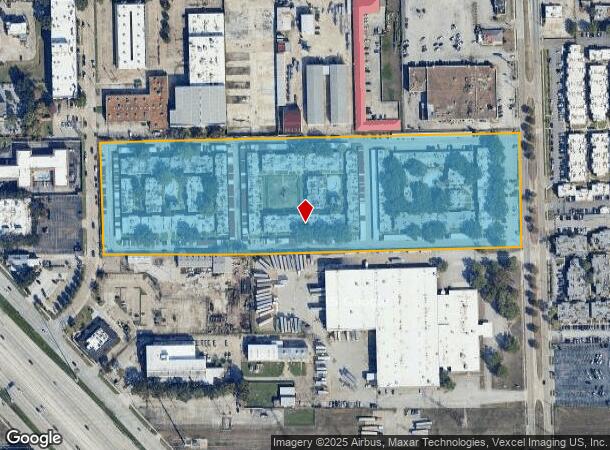
Property Record
3233 Mangum Rd, Houston, TX 77092

NEARBY LISTINGS FOR SALE OR LEASE
Property Detail
3233 Mangum Rd
0421300000003
Abst 269 J Flowers
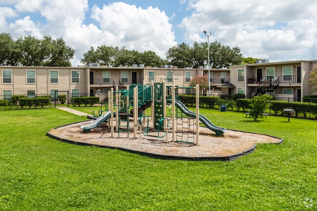
Apartment
TR 13 ABST 269 J FLOWERS
X
Harris
48201C0655M
Texas
2024
12.81 AC
2025
Oak Forest-Garden Oaks
530102
Houston
333,616 SF
Houston-Pasadena-The Woodlands, TX
DEMOGRAPHICS near 3233 Mangum Rd
1 Mile
3 Mile
5 Mile
2024 Total Population
14,847
147,041
388,520
2029 Population
15,453
152,076
401,945
Pop Growth 2024-2029
+ 4.08%
+ 3.42%
+ 3.46%
Average Age
36
36
38
2024 Total Households
6,247
58,705
159,935
HH Growth 2024-2029
+ 3.92%
+ 3.45%
+ 3.58%
Median Household Inc
$40,828
$64,034
$72,734
Avg Household Size
2.30
2.40
2.40
2024 Avg HH Vehicles
2.00
2.00
2.00
Median Home Value
$283,115
$391,354
$401,164
Median Year Built
1975
1978
1982
Nearby Places
Map Layers
Map Styles
 Street
 Aerial
- Restaurants
- Banks
- Shops
- Fitness
- Groceries
PUBLIC TRANSPORTATION
COMMUTER RAIL
DRIVE
WALK
Distance
16 min
8.8 mi
AIRPORT
William P Hobby
DRIVE
WALK
Distance
William P Hobby
37 min
21.2 mi
George Bush Intcntl/Houston
DRIVE
WALK
Distance
George Bush Intcntl/Houston
30 min
22.8 mi
Freight Ports
Port of Houston
DRIVE
WALK
Distance
Port of Houston
28 min
18.0 mi
Nearby Properties
Address
Land Use
TOTAL SIZE
Lot Size
Zoning
Address
Land Use
TOTAL SIZE
Lot Size
Zoning
563,626 SF
4.71 AC
Address
Land Use
TOTAL SIZE
Lot Size
Zoning
224,114 SF
4.24 AC
Address
Land Use
TOTAL SIZE
Lot Size
Zoning
714,049 SF
25.73 AC
Address
Land Use
TOTAL SIZE
Lot Size
Zoning
366,386 SF
10.85 AC
Address
Land Use
TOTAL SIZE
Lot Size
Zoning
375,693 SF
9.16 AC
Address
Land Use
TOTAL SIZE
Lot Size
Zoning
605,420 SF
7.51 AC
Address
Land Use
TOTAL SIZE
Lot Size
Zoning
350,655 SF
16.76 AC
Address
Land Use
TOTAL SIZE
Lot Size
Zoning
279,934 SF
8 AC
Address
Land Use
TOTAL SIZE
Lot Size
Zoning
721,788 SF
10.14 AC
Address
Land Use
TOTAL SIZE
Lot Size
Zoning
292,292 SF
10.36 AC
Address
Land Use
TOTAL SIZE
Lot Size
Zoning
270,845 SF
10.75 AC
Address
Land Use
TOTAL SIZE
Lot Size
Zoning
443,228 SF
3.15 AC
Address
Land Use
TOTAL SIZE
Lot Size
Zoning
478,524 SF
5.68 AC
Address
Land Use
TOTAL SIZE
Lot Size
Zoning
750,156 SF
22.95 AC
Address
Land Use
TOTAL SIZE
Lot Size
Zoning
322,880 SF
2.61 AC
Address
Land Use
TOTAL SIZE
Lot Size
Zoning
363,503 SF
12.81 AC
Address
Land Use
TOTAL SIZE
Lot Size
Zoning
402,433 SF
2.77 AC
Address
Land Use
TOTAL SIZE
Lot Size
Zoning
293,407 SF
9.19 AC
Address
Land Use
TOTAL SIZE
Lot Size
Zoning
378,225 SF
11.51 AC
Address
Land Use
TOTAL SIZE
Lot Size
Zoning
280,241 SF
1.90 AC
Address
Land Use
TOTAL SIZE
Lot Size
Zoning
418,456 SF
5.72 AC
Address
Land Use
TOTAL SIZE
Lot Size
Zoning
394,910 SF
15.04 AC
Address
Land Use
TOTAL SIZE
Lot Size
Zoning
185,068 SF
21.92 AC
Address
Land Use
TOTAL SIZE
Lot Size
Zoning
387,788 SF
17.95 AC
Address
Land Use
TOTAL SIZE
Lot Size
Zoning
229,369 SF
4 AC
Address
Land Use
TOTAL SIZE
Lot Size
Zoning
304,557 SF
4.90 AC
Address
Land Use
TOTAL SIZE
Lot Size
Zoning
198,259 SF
19.57 AC
Address
Land Use
TOTAL SIZE
Lot Size
Zoning
228,804 SF
3.28 AC
Address
Land Use
TOTAL SIZE
Lot Size
Zoning
265,830 SF
14.53 AC
Address
Land Use
TOTAL SIZE
Lot Size
Zoning
259,716 SF
6.31 AC
The World's #1 Commercial Real Estate Marketplace
Connect with us
© 2026 CoStar Group
The information above has been obtained from sources believed reliable. While we do not doubt its accuracy we have not verified it and make no guarantee, warranty or representation about it. It is your responsibility to independently confirm its accuracy and completeness. Any projections, opinions, assumptions, or estimates used are for example only and do not represent the current or future performance of the property. The value of this transaction to you depends on tax and other factors which should be evaluated by your tax, financial, and legal advisors. You and your advisors should conduct a careful, independent investigation of the property to determine to your satisfaction the suitability of the property for your needs.