Property Record
3233 S Kingshighway Blvd, Saint Louis, MO 63139
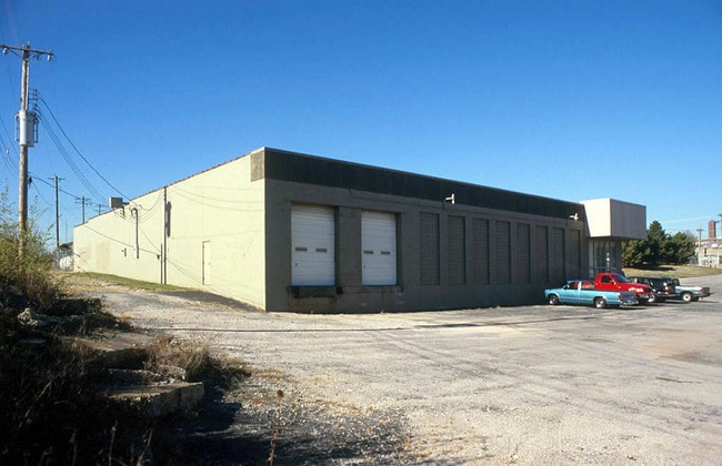
This Property Is For Sale
NEARBY LISTINGS FOR SALE OR LEASE
Property Detail
3233 S Kingshighway Blvd
St. Louis, MO-IL
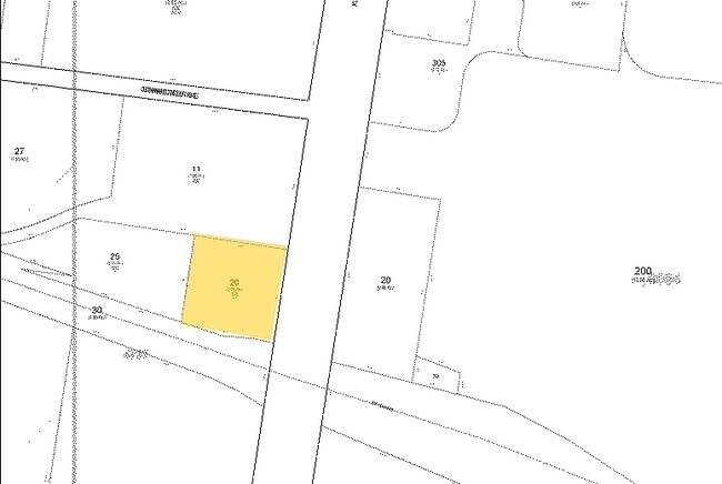
Lindell Addn
4737-00-0025-0
CB 4737 NO FRONT 0.791 ACS LINDELL ADDN LOT PT 2 & 3 BD E-160 FT W OF KINGSHIGHWAY
Industrialgeneral
St. Louis City
X
Missouri
2903850082C
2,3
2024
0.79 AC
2025
St Louis City South
127200
St. Louis
12,000 SF
DEMOGRAPHICS near 3233 S Kingshighway Blvd
1 Mile
3 Mile
5 Mile
2024 Total Population
16,276
156,598
351,289
2029 Population
14,913
145,646
335,229
Pop Growth 2024-2029
(8.37%)
(6.99%)
(4.57%)
Average Age
40
39
39
2024 Total Households
8,730
77,290
166,031
HH Growth 2024-2029
(8.33%)
(6.94%)
(4.74%)
Median Household Inc
$59,259
$58,095
$58,539
Avg Household Size
1.80
1.90
2.00
2024 Avg HH Vehicles
1.00
1.00
1.00
Median Home Value
$180,624
$199,483
$206,285
Median Year Built
1947
1947
1948
Nearby Places
- Restaurants
- Banks
- Shops
- Fitness
- Groceries
PUBLIC TRANSPORTATION
COMMUTER RAIL
DRIVE
WALK
Distance
7 min
2.6 mi
Central West End (Lambert Airport Shiloh-Scott - St. Louis MetroLink (MetroLink), Shrewsbury-Lansdowne I-44 Emerson Park - St. Louis MetroLink (MetroLink))
DRIVE
WALK
Distance
Central West End (Lambert Airport Shiloh-Scott - St. Louis MetroLink (MetroLink), Shrewsbury-Lansdowne I-44 Emerson Park - St. Louis MetroLink (MetroLink))
7 min
2.7 mi
AIRPORT
St Louis Lambert International
DRIVE
WALK
Distance
St Louis Lambert International
26 min
16.1 mi
Scott AFB/Midamerica St Louis
DRIVE
WALK
Distance
Scott AFB/Midamerica St Louis
48 min
30.6 mi
Nearby Properties
Address
Land Use
TOTAL SIZE
Lot Size
Zoning
Address
Land Use
TOTAL SIZE
Lot Size
Zoning
0.92 AC
A
Address
Land Use
TOTAL SIZE
Lot Size
Zoning
5.61 AC
A
Address
Land Use
TOTAL SIZE
Lot Size
Zoning
136.92 AC
AI
Address
Land Use
TOTAL SIZE
Lot Size
Zoning
1,361,485 SF
5.45 AC
E
Address
Land Use
TOTAL SIZE
Lot Size
Zoning
229.57 AC
B
Address
Land Use
TOTAL SIZE
Lot Size
Zoning
177.77 AC
A
Address
Land Use
TOTAL SIZE
Lot Size
Zoning
624,049 SF
20.78 AC
K
Address
Land Use
TOTAL SIZE
Lot Size
Zoning
246,345 SF
4.17 AC
J
Address
Land Use
TOTAL SIZE
Lot Size
Zoning
1.98 AC
H
Address
Land Use
TOTAL SIZE
Lot Size
Zoning
57.77 AC
A
Address
Land Use
TOTAL SIZE
Lot Size
Zoning
6.05 AC
J
Address
Land Use
TOTAL SIZE
Lot Size
Zoning
423,303 SF
9.97 AC
H
Address
Land Use
TOTAL SIZE
Lot Size
Zoning
306,459 SF
4.79 AC
H
Address
Land Use
TOTAL SIZE
Lot Size
Zoning
225,920 SF
2.02 AC
H
Address
Land Use
TOTAL SIZE
Lot Size
Zoning
358,243 SF
3.02 AC
H
Address
Land Use
TOTAL SIZE
Lot Size
Zoning
248,809 SF
3.23 AC
H
Address
Land Use
TOTAL SIZE
Lot Size
Zoning
189,841 SF
4.18 AC
K
Address
Land Use
TOTAL SIZE
Lot Size
Zoning
309,734 SF
3.41 AC
E
Address
Land Use
TOTAL SIZE
Lot Size
Zoning
191,584 SF
1.76 AC
K
Address
Land Use
TOTAL SIZE
Lot Size
Zoning
191,352 SF
4.41 AC
K
Address
Land Use
TOTAL SIZE
Lot Size
Zoning
112,656 SF
3.55 AC
HK
Address
Land Use
TOTAL SIZE
Lot Size
Zoning
628,939 SF
2.73 AC
J
Address
Land Use
TOTAL SIZE
Lot Size
Zoning
256,400 SF
3.67 AC
H
Address
Land Use
TOTAL SIZE
Lot Size
Zoning
177,974 SF
2.29 AC
J
Address
Land Use
TOTAL SIZE
Lot Size
Zoning
2.03 AC
HC
Address
Land Use
TOTAL SIZE
Lot Size
Zoning
184,183 SF
1.96 AC
J
Address
Land Use
TOTAL SIZE
Lot Size
Zoning
275,012 SF
4.39 AC
C
Address
Land Use
TOTAL SIZE
Lot Size
Zoning
22.44 AC
A
Address
Land Use
TOTAL SIZE
Lot Size
Zoning
432,844 SF
5.08 AC
JK
Address
Land Use
TOTAL SIZE
Lot Size
Zoning
248,372 SF
1.50 AC
E
The World's #1 Commercial Real Estate Marketplace
Connect with us
© 2025 CoStar Group
The information above has been obtained from sources believed reliable. While we do not doubt its accuracy we have not verified it and make no guarantee, warranty or representation about it. It is your responsibility to independently confirm its accuracy and completeness. Any projections, opinions, assumptions, or estimates used are for example only and do not represent the current or future performance of the property. The value of this transaction to you depends on tax and other factors which should be evaluated by your tax, financial, and legal advisors. You and your advisors should conduct a careful, independent investigation of the property to determine to your satisfaction the suitability of the property for your needs.