Property Record
Alexandersville Bellbrook Rd, West Carrollton, OH 45449
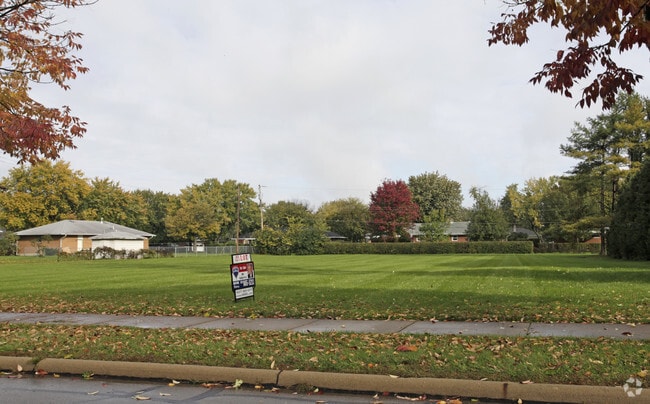
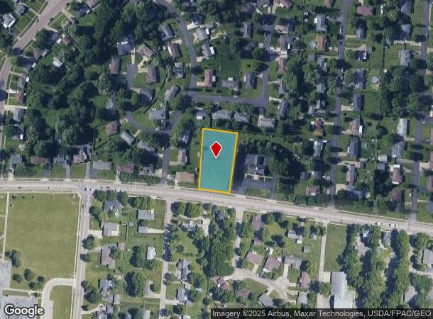
This Property Is For Sale
NEARBY LISTINGS FOR SALE OR LEASE
Property Detail
Alexandersville Bellbrook Rd
Dayton, OH
Farmers And Merchants Bank Plat
K48-00419-0002
4551 FARMERS AND MERCHANTS BANK PLAT
Commercialacreage
Montgomery
X
Ohio
39113C0261E
0.81 AC
2023
South Dayton
2024
Cincinnati/Dayton
050302
DEMOGRAPHICS near Alexandersville Bellbrook Rd
1 Mile
3 Mile
5 Mile
2024 Total Population
10,038
48,895
145,743
2029 Population
9,859
48,142
144,159
Pop Growth 2024-2029
(1.78%)
(1.54%)
(1.09%)
Average Age
43
42
41
2024 Total Households
4,534
21,161
63,280
HH Growth 2024-2029
(1.85%)
(1.69%)
(1.14%)
Median Household Inc
$49,263
$63,785
$66,640
Avg Household Size
2.10
2.20
2.20
2024 Avg HH Vehicles
2.00
2.00
2.00
Median Home Value
$138,410
$173,382
$188,333
Median Year Built
1971
1970
1968
Nearby Places
- Restaurants
- Banks
- Shops
- Fitness
- Groceries
PUBLIC TRANSPORTATION
AIRPORT
James M Cox Dayton International
DRIVE
WALK
Distance
James M Cox Dayton International
30 min
19.3 mi
Freight Ports
Port of Toledo
DRIVE
WALK
Distance
Port of Toledo
187 min
159.5 mi
Nearby Properties
Address
Land Use
TOTAL SIZE
Lot Size
Zoning
Address
Land Use
TOTAL SIZE
Lot Size
Zoning
428,925 SF
21.70 AC
Address
Land Use
TOTAL SIZE
Lot Size
Zoning
104,240 SF
36.80 AC
Address
Land Use
TOTAL SIZE
Lot Size
Zoning
25,715 SF
23.28 AC
Address
Land Use
TOTAL SIZE
Lot Size
Zoning
1,042,121 SF
51.37 AC
Address
Land Use
TOTAL SIZE
Lot Size
Zoning
Address
Land Use
TOTAL SIZE
Lot Size
Zoning
3.27 AC
Address
Land Use
TOTAL SIZE
Lot Size
Zoning
6,204 SF
19.27 AC
Address
Land Use
TOTAL SIZE
Lot Size
Zoning
94.06 AC
Address
Land Use
TOTAL SIZE
Lot Size
Zoning
318,347 SF
26.75 AC
Address
Land Use
TOTAL SIZE
Lot Size
Zoning
71,204 SF
5.15 AC
Address
Land Use
TOTAL SIZE
Lot Size
Zoning
69,939 SF
90.27 AC
Address
Land Use
TOTAL SIZE
Lot Size
Zoning
66.56 AC
Address
Land Use
TOTAL SIZE
Lot Size
Zoning
1,042,121 SF
51.37 AC
Address
Land Use
TOTAL SIZE
Lot Size
Zoning
138,484 SF
23.04 AC
Address
Land Use
TOTAL SIZE
Lot Size
Zoning
155,702 SF
5.95 AC
Address
Land Use
TOTAL SIZE
Lot Size
Zoning
414,124 SF
14.98 AC
Address
Land Use
TOTAL SIZE
Lot Size
Zoning
330,404 SF
68.13 AC
Address
Land Use
TOTAL SIZE
Lot Size
Zoning
206,027 SF
28.63 AC
Address
Land Use
TOTAL SIZE
Lot Size
Zoning
70,234 SF
11.22 AC
Address
Land Use
TOTAL SIZE
Lot Size
Zoning
82,510 SF
12.79 AC
Address
Land Use
TOTAL SIZE
Lot Size
Zoning
118,234 SF
25.72 AC
Address
Land Use
TOTAL SIZE
Lot Size
Zoning
109,750 SF
15.38 AC
Address
Land Use
TOTAL SIZE
Lot Size
Zoning
105,098 SF
5.55 AC
Address
Land Use
TOTAL SIZE
Lot Size
Zoning
600,884 SF
38.61 AC
Address
Land Use
TOTAL SIZE
Lot Size
Zoning
22,590 SF
4.20 AC
Address
Land Use
TOTAL SIZE
Lot Size
Zoning
101,769 SF
20.65 AC
Address
Land Use
TOTAL SIZE
Lot Size
Zoning
162,528 SF
14.70 AC
Address
Land Use
TOTAL SIZE
Lot Size
Zoning
10,152 SF
7.57 AC
Address
Land Use
TOTAL SIZE
Lot Size
Zoning
439,169 SF
16 AC
Address
Land Use
TOTAL SIZE
Lot Size
Zoning
121,875 SF
8.21 AC
The World's #1 Commercial Real Estate Marketplace
Connect with us
© 2025 CoStar Group
The information above has been obtained from sources believed reliable. While we do not doubt its accuracy we have not verified it and make no guarantee, warranty or representation about it. It is your responsibility to independently confirm its accuracy and completeness. Any projections, opinions, assumptions, or estimates used are for example only and do not represent the current or future performance of the property. The value of this transaction to you depends on tax and other factors which should be evaluated by your tax, financial, and legal advisors. You and your advisors should conduct a careful, independent investigation of the property to determine to your satisfaction the suitability of the property for your needs.