Property Record
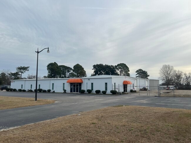
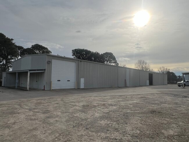
3235 Us Highway 301 S, Wilson, NC 27893
NEARBY LISTINGS FOR SALE OR LEASE
-
-
View all Wilson listings for sale on LoopNet.com
Property Detail
3235 Us Highway 301 S
3710-14-6107.000
3235 US 301 HWY S L1 6.58AC ANNEX 06/05 EFF 07/05
Warehouse
Wilson
X
North Carolina
3720371000K
6.58 AC
2024
Rocky Mount/Wilson
2025
Other Market Areas
000900
Wilson, NC
10,500 SF
DEMOGRAPHICS near 3235 Us Highway 301 S
1 Mile
3 Mile
5 Mile
2024 Total Population
567
10,067
40,341
2029 Population
570
10,049
40,542
Pop Growth 2024-2029
+ 0.53%
(0.18%)
+ 0.50%
Average Age
42
42
41
2024 Total Households
222
4,116
16,604
HH Growth 2024-2029
+ 0.45%
(0.24%)
+ 0.46%
Median Household Inc
$51,956
$46,762
$42,685
Avg Household Size
2.40
2.30
2.30
2024 Avg HH Vehicles
2.00
2.00
2.00
Median Home Value
$130,769
$112,773
$135,367
Median Year Built
1979
1982
1978
Nearby Places
Map Layers
Map Styles
 Street
 Aerial
- Restaurants
- Banks
- Shops
- Fitness
- Groceries
PUBLIC TRANSPORTATION
COMMUTER RAIL
Wilson (Carolinian - Amtrak, Palmetto - Amtrak)
DRIVE
WALK
Distance
Wilson (Carolinian - Amtrak, Palmetto - Amtrak)
8 min
4.0 mi
Freight Ports
Port of Morehead City
DRIVE
WALK
Distance
Port of Morehead City
163 min
123.9 mi
SALE & LEASE HISTORY
LISTING DATE
SALE/LEASE

Jan 23, 2024
For Sale
Nearby Properties
Address
Land Use
TOTAL SIZE
Lot Size
Zoning
Address
Land Use
TOTAL SIZE
Lot Size
Zoning
11,771 SF
31.78 AC
ICD
Address
Land Use
TOTAL SIZE
Lot Size
Zoning
259,000 SF
69.97 AC
HI
Address
Land Use
TOTAL SIZE
Lot Size
Zoning
150,316 SF
10.97 AC
RMX
Address
Land Use
TOTAL SIZE
Lot Size
Zoning
192,420 SF
34.36 AC
HI
Address
Land Use
TOTAL SIZE
Lot Size
Zoning
1,944 SF
13.64 AC
GR6
Address
Land Use
TOTAL SIZE
Lot Size
Zoning
8,616 SF
40 AC
ICD
Address
Land Use
TOTAL SIZE
Lot Size
Zoning
3,900 SF
16.46 AC
RMX
Address
Land Use
TOTAL SIZE
Lot Size
Zoning
112,721 SF
22.04 AC
GC
Address
Land Use
TOTAL SIZE
Lot Size
Zoning
39,321 SF
5.55 AC
ICD
Address
Land Use
TOTAL SIZE
Lot Size
Zoning
45,354 SF
14.50 AC
R15
Address
Land Use
TOTAL SIZE
Lot Size
Zoning
9,548 SF
33.53 AC
LI
Address
Land Use
TOTAL SIZE
Lot Size
Zoning
2,464 SF
12.82 AC
ICD
Address
Land Use
TOTAL SIZE
Lot Size
Zoning
7,260 SF
6.99 AC
RMX
Address
Land Use
TOTAL SIZE
Lot Size
Zoning
2,500 SF
34.70 AC
M2
Address
Land Use
TOTAL SIZE
Lot Size
Zoning
59,760 SF
16.60 AC
M1
Address
Land Use
TOTAL SIZE
Lot Size
Zoning
195,718 SF
36.18 AC
HI
Address
Land Use
TOTAL SIZE
Lot Size
Zoning
2,475 SF
10.62 AC
HC
Address
Land Use
TOTAL SIZE
Lot Size
Zoning
44,226 SF
5.45 AC
GR6
Address
Land Use
TOTAL SIZE
Lot Size
Zoning
60,704 SF
5.01 AC
GC
Address
Land Use
TOTAL SIZE
Lot Size
Zoning
86,826 SF
26.27 AC
HI
Address
Land Use
TOTAL SIZE
Lot Size
Zoning
57,737 SF
7 AC
B3
Address
Land Use
TOTAL SIZE
Lot Size
Zoning
52,500 SF
30.14 AC
HI
Address
Land Use
TOTAL SIZE
Lot Size
Zoning
24,136 SF
5.10 AC
GC
Address
Land Use
TOTAL SIZE
Lot Size
Zoning
3,675 SF
34 AC
HI
Address
Land Use
TOTAL SIZE
Lot Size
Zoning
4,753 SF
59.25 AC
HI
Address
Land Use
TOTAL SIZE
Lot Size
Zoning
202,700 SF
12.78 AC
HI
Address
Land Use
TOTAL SIZE
Lot Size
Zoning
87,400 SF
11.45 AC
HI
Address
Land Use
TOTAL SIZE
Lot Size
Zoning
3,500 SF
13.16 AC
HI
Address
Land Use
TOTAL SIZE
Lot Size
Zoning
1,500 SF
7.10 AC
RMX
Address
Land Use
TOTAL SIZE
Lot Size
Zoning
45,300 SF
13.44 AC
GC
The World's #1 Commercial Real Estate Marketplace
Connect with us
© 2026 CoStar Group
The information above has been obtained from sources believed reliable. While we do not doubt its accuracy we have not verified it and make no guarantee, warranty or representation about it. It is your responsibility to independently confirm its accuracy and completeness. Any projections, opinions, assumptions, or estimates used are for example only and do not represent the current or future performance of the property. The value of this transaction to you depends on tax and other factors which should be evaluated by your tax, financial, and legal advisors. You and your advisors should conduct a careful, independent investigation of the property to determine to your satisfaction the suitability of the property for your needs.