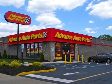
Property Record
3237 Fm 1960 Rd E, Humble, TX 77338

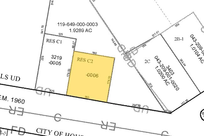
Property Detail
3237 Fm 1960 Rd E
1196490000003
RES C CROSSROADS SHOPPING CENTER
Commercialnec
HARRIS
B and X Area of moderate flood hazard, usually the area between the limits of the 100-year and 500-year floods.
Texas
2025
0.61 AC
2025
Kingwood/Humble
240904
Houston
1,519 SF
Houston-Pasadena-The Woodlands, TX
NEARBY LISTINGS FOR SALE OR LEASE
DEMOGRAPHICS near 3237 Fm 1960 Rd E
1 mile
3 mile
5 mile
2025 Total Population
8,823
80,213
213,609
2030 Population
9,499
85,863
229,350
Pop Growth 2025-2030
+ 7.66%
+ 7.04%
+ 7.37%
Average Age
34
35
34
2025 Total Households
2,901
26,084
72,252
HH Growth 2025-2030
+ 7.86%
+ 7.32%
+ 7.63%
Median Household Inc
$63,179
$73,726
$68,366
Avg Household Size
3.00
3.00
2.90
2025 Avg HH Vehicles
2.00
2.00
2.00
Median Home Value
$247,159
$225,217
$244,947
Median Year Built
2005
1996
1996
Nearby Places
Map Layers
Map Styles
 Street
 Aerial
Layers
 Traffic
 Biking
Places
Listings with unknown addresses are not visible on the map
- Restaurants
- Banks
- Shops
- Fitness
- Groceries
PUBLIC TRANSPORTATION
AIRPORT
George Bush Intcntl/Houston
Drive
Walk
Distance
George Bush Intcntl/Houston
16 min
9.1 mi
William P Hobby
Drive
Walk
Distance
William P Hobby
51 min
33.0 mi
Freight Ports
Port of Houston
Drive
Walk
Distance
Port of Houston
39 min
27.0 mi
Nearby Properties
Address
Land Use
TOTAL SIZE
Lot Size
Zoning
Address
Land Use
TOTAL SIZE
Lot Size
Zoning
409,480 SF
27.32 AC
Address
Land Use
TOTAL SIZE
Lot Size
Zoning
350,423 SF
122.83 AC
Address
Land Use
TOTAL SIZE
Lot Size
Zoning
280,283 SF
16.56 AC
Address
Land Use
TOTAL SIZE
Lot Size
Zoning
435,650 SF
Address
Land Use
TOTAL SIZE
Lot Size
Zoning
271,432 SF
35.81 AC
Address
Land Use
TOTAL SIZE
Lot Size
Zoning
318,000 SF
18.53 AC
Address
Land Use
TOTAL SIZE
Lot Size
Zoning
287,251 SF
18.12 AC
Address
Land Use
TOTAL SIZE
Lot Size
Zoning
259,000 SF
14.73 AC
Address
Land Use
TOTAL SIZE
Lot Size
Zoning
259,000 SF
15.73 AC
Address
Land Use
TOTAL SIZE
Lot Size
Zoning
204,870 SF
13.40 AC
Address
Land Use
TOTAL SIZE
Lot Size
Zoning
203,013 SF
12.28 AC
Address
Land Use
TOTAL SIZE
Lot Size
Zoning
238,835 SF
9.98 AC
Address
Land Use
TOTAL SIZE
Lot Size
Zoning
249,296 SF
10.10 AC
Address
Land Use
TOTAL SIZE
Lot Size
Zoning
175,495 SF
8.92 AC
Address
Land Use
TOTAL SIZE
Lot Size
Zoning
267,250 SF
11.83 AC
Address
Land Use
TOTAL SIZE
Lot Size
Zoning
127,260 SF
14 AC
Address
Land Use
TOTAL SIZE
Lot Size
Zoning
159,775 SF
8.77 AC
Address
Land Use
TOTAL SIZE
Lot Size
Zoning
222,382 SF
10.44 AC
Address
Land Use
TOTAL SIZE
Lot Size
Zoning
159,514 SF
11.40 AC
Address
Land Use
TOTAL SIZE
Lot Size
Zoning
132,102 SF
14.93 AC
Address
Land Use
TOTAL SIZE
Lot Size
Zoning
99,561 SF
11.60 AC
Address
Land Use
TOTAL SIZE
Lot Size
Zoning
222,903 SF
8.46 AC
Address
Land Use
TOTAL SIZE
Lot Size
Zoning
199,176 SF
10.63 AC
Address
Land Use
TOTAL SIZE
Lot Size
Zoning
125,674 SF
11.56 AC
Address
Land Use
TOTAL SIZE
Lot Size
Zoning
216,390 SF
8.42 AC
Address
Land Use
TOTAL SIZE
Lot Size
Zoning
179,748 SF
6.60 AC
Address
Land Use
TOTAL SIZE
Lot Size
Zoning
281,563 SF
19.98 AC
Address
Land Use
TOTAL SIZE
Lot Size
Zoning
186,971 SF
7.58 AC
Address
Land Use
TOTAL SIZE
Lot Size
Zoning
152,440 SF
24.67 AC
Address
Land Use
TOTAL SIZE
Lot Size
Zoning
288,503 SF
14.57 AC
The World's #1 Commercial Real Estate Marketplace
Connect with us
© 2026 CoStar Group
The information above has been obtained from sources believed reliable. While we do not doubt its accuracy we have not verified it and make no guarantee, warranty or representation about it. It is your responsibility to independently confirm its accuracy and completeness. Any projections, opinions, assumptions, or estimates used are for example only and do not represent the current or future performance of the property. The value of this transaction to you depends on tax and other factors which should be evaluated by your tax, financial, and legal advisors. You and your advisors should conduct a careful, independent investigation of the property to determine to your satisfaction the suitability of the property for your needs.