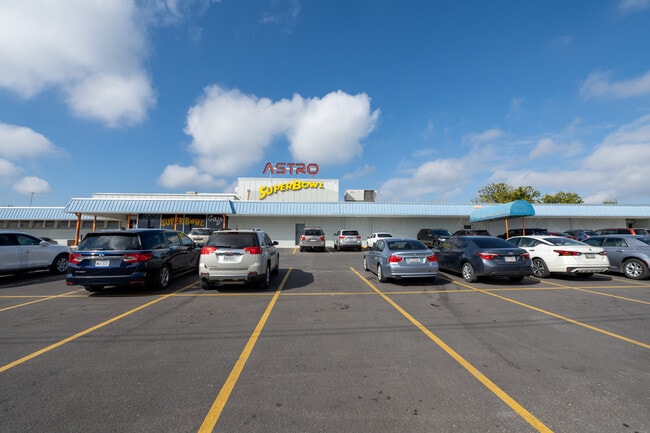
Property Record
3239 Harry Wurzbach Rd, San Antonio, TX 78209

NEARBY LISTINGS FOR SALE OR LEASE
Property Detail
3239 Harry Wurzbach Rd
San Antonio-New Braunfels, TX
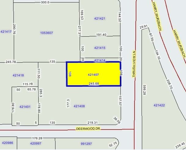
Austin Hwy Heights Sub Bl 8711
08711-001-0190
NCB 8711 BLK C LOT 19, 21, 22 &, S 20 FT OF 30 2014-NEW RMS PER MERGE PER CR 30581, MERGED 421408 INTO 421407, SEE DELETED ACCT 421408. JPR/GIS/09-04-13
Bowlingalley
Bexar
X
Texas
48029C0406H
19
2024
2.62 AC
2025
Northeast
120602
San Antonio
38,283 SF
DEMOGRAPHICS near 3239 Harry Wurzbach Rd
1 Mile
3 Mile
5 Mile
2024 Total Population
14,473
91,636
256,385
2029 Population
15,479
97,795
273,568
Pop Growth 2024-2029
+ 6.95%
+ 6.72%
+ 6.70%
Average Age
40
39
38
2024 Total Households
6,487
37,922
101,437
HH Growth 2024-2029
+ 7.09%
+ 6.89%
+ 6.94%
Median Household Inc
$58,700
$59,075
$54,996
Avg Household Size
2.10
2.20
2.40
2024 Avg HH Vehicles
2.00
2.00
2.00
Median Home Value
$344,106
$314,506
$214,606
Median Year Built
1972
1972
1974
Nearby Places
Map Layers
Map Styles
 Street
 Aerial
- Restaurants
- Banks
- Shops
- Fitness
- Groceries
PUBLIC TRANSPORTATION
COMMUTER RAIL
DRIVE
WALK
Distance
14 min
7.6 mi
AIRPORT
San Antonio International
DRIVE
WALK
Distance
San Antonio International
9 min
4.4 mi
SALE & LEASE HISTORY
LISTING DATE
SALE/LEASE

Nov 19, 2021
For Sale
Nearby Properties
Address
Land Use
TOTAL SIZE
Lot Size
Zoning
Address
Land Use
TOTAL SIZE
Lot Size
Zoning
557,078 SF
10.73 AC
Address
Land Use
TOTAL SIZE
Lot Size
Zoning
1,649,488 SF
70 AC
Address
Land Use
TOTAL SIZE
Lot Size
Zoning
246,000 SF
22.54 AC
Address
Land Use
TOTAL SIZE
Lot Size
Zoning
25,513 SF
18.14 AC
Address
Land Use
TOTAL SIZE
Lot Size
Zoning
46,451 SF
7.03 AC
Address
Land Use
TOTAL SIZE
Lot Size
Zoning
56,042 SF
14.60 AC
Address
Land Use
TOTAL SIZE
Lot Size
Zoning
239,264 SF
9.02 AC
Address
Land Use
TOTAL SIZE
Lot Size
Zoning
262,515 SF
6.38 AC
Address
Land Use
TOTAL SIZE
Lot Size
Zoning
316,556 SF
6.56 AC
Address
Land Use
TOTAL SIZE
Lot Size
Zoning
10,342 SF
1.41 AC
Address
Land Use
TOTAL SIZE
Lot Size
Zoning
23,738 SF
4.84 AC
Address
Land Use
TOTAL SIZE
Lot Size
Zoning
268,495 SF
13.04 AC
Address
Land Use
TOTAL SIZE
Lot Size
Zoning
307,193 SF
7.18 AC
Address
Land Use
TOTAL SIZE
Lot Size
Zoning
157,762 SF
9.26 AC
Address
Land Use
TOTAL SIZE
Lot Size
Zoning
598,070 SF
46.05 AC
Address
Land Use
TOTAL SIZE
Lot Size
Zoning
328,605 SF
25.69 AC
Address
Land Use
TOTAL SIZE
Lot Size
Zoning
245,160 SF
15.10 AC
Address
Land Use
TOTAL SIZE
Lot Size
Zoning
74,510 SF
6.58 AC
Address
Land Use
TOTAL SIZE
Lot Size
Zoning
279,012 SF
12.17 AC
Address
Land Use
TOTAL SIZE
Lot Size
Zoning
273,516 SF
17.50 AC
Address
Land Use
TOTAL SIZE
Lot Size
Zoning
265,015 SF
12.81 AC
Address
Land Use
TOTAL SIZE
Lot Size
Zoning
58,461 SF
3.60 AC
Address
Land Use
TOTAL SIZE
Lot Size
Zoning
275,327 SF
13.52 AC
Address
Land Use
TOTAL SIZE
Lot Size
Zoning
373,134 SF
16.29 AC
Address
Land Use
TOTAL SIZE
Lot Size
Zoning
364,894 SF
10.28 AC
Address
Land Use
TOTAL SIZE
Lot Size
Zoning
72,611 SF
10.73 AC
Address
Land Use
TOTAL SIZE
Lot Size
Zoning
222,865 SF
17.75 AC
Address
Land Use
TOTAL SIZE
Lot Size
Zoning
152,394 SF
5.67 AC
Address
Land Use
TOTAL SIZE
Lot Size
Zoning
300,555 SF
29.35 AC
Address
Land Use
TOTAL SIZE
Lot Size
Zoning
106,139 SF
5.84 AC
The World's #1 Commercial Real Estate Marketplace
Connect with us
© 2025 CoStar Group
The information above has been obtained from sources believed reliable. While we do not doubt its accuracy we have not verified it and make no guarantee, warranty or representation about it. It is your responsibility to independently confirm its accuracy and completeness. Any projections, opinions, assumptions, or estimates used are for example only and do not represent the current or future performance of the property. The value of this transaction to you depends on tax and other factors which should be evaluated by your tax, financial, and legal advisors. You and your advisors should conduct a careful, independent investigation of the property to determine to your satisfaction the suitability of the property for your needs.