Property Record
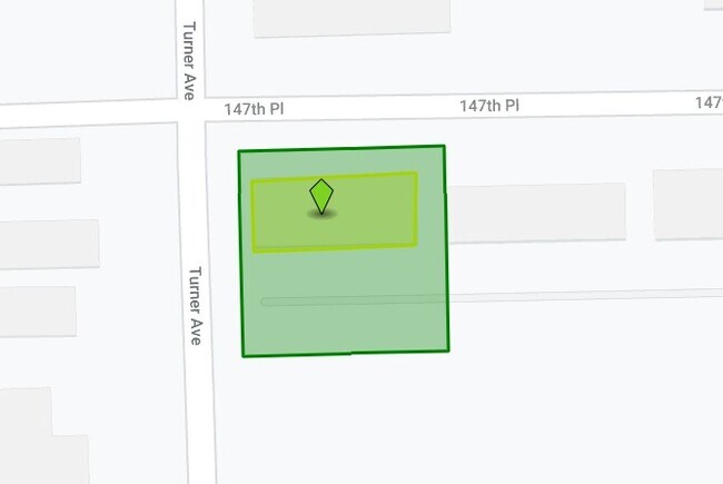
3240 147Th Pl, Midlothian, IL 60445
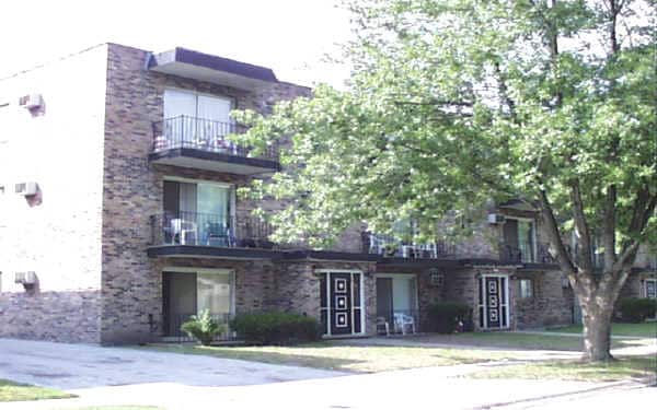
Property Detail
3240 147Th Pl
28-11-408-051-0000
COOK
Apartment
Illinois
B and X Area of moderate flood hazard, usually the area between the limits of the 100-year and 500-year floods.
0.42 AC
2023
Southwest Cook County
2025
Chicago
824702
Chicago-Naperville-Elgin, IL-IN
11,060 SF
NEARBY LISTINGS FOR SALE OR LEASE
DEMOGRAPHICS near 3240 147Th Pl
1 mile
3 mile
5 mile
2025 Total Population
15,585
98,892
276,008
2030 Population
15,808
101,965
281,745
Pop Growth 2025-2030
+ 1.43%
+ 3.11%
+ 2.08%
Average Age
39
40
41
2025 Total Households
5,114
36,104
102,950
HH Growth 2025-2030
+ 1.21%
+ 3.05%
+ 1.92%
Median Household Inc
$65,237
$61,622
$65,931
Avg Household Size
2.90
2.60
2.60
2025 Avg HH Vehicles
2.00
2.00
2.00
Median Home Value
$187,320
$178,941
$196,243
Median Year Built
1963
1969
1966
Nearby Places
Map Layers
Map Styles
 Street
 Aerial
Layers
 Traffic
 Biking
Places
Listings with unknown addresses are not visible on the map
- Restaurants
- Banks
- Shops
- Fitness
- Groceries
PUBLIC TRANSPORTATION
COMMUTER RAIL
Midlothian Station (Rock Island District Line - Northeast Illinois Regional Commuter Railroad (Metra))
Drive
Walk
Distance
Midlothian Station (Rock Island District Line - Northeast Illinois Regional Commuter Railroad (Metra))
2 min
14 min
0.7 mi
Robbins Station (Rock Island District Line - Northeast Illinois Regional Commuter Railroad (Metra))
Drive
Walk
Distance
Robbins Station (Rock Island District Line - Northeast Illinois Regional Commuter Railroad (Metra))
4 min
1.6 mi
AIRPORT
Chicago Midway International
Drive
Walk
Distance
Chicago Midway International
23 min
14.2 mi
Chicago O'Hare International
Drive
Walk
Distance
Chicago O'Hare International
48 min
35.9 mi
Freight Ports
Port Milwaukee
Drive
Walk
Distance
Port Milwaukee
130 min
107.7 mi
Nearby Properties
Address
Land Use
TOTAL SIZE
Lot Size
Zoning
Address
Land Use
TOTAL SIZE
Lot Size
Zoning
Address
Land Use
TOTAL SIZE
Lot Size
Zoning
380,924 SF
19.13 AC
Address
Land Use
TOTAL SIZE
Lot Size
Zoning
421,052 SF
26.15 AC
Address
Land Use
TOTAL SIZE
Lot Size
Zoning
44,184 SF
5 AC
Address
Land Use
TOTAL SIZE
Lot Size
Zoning
152,306 SF
13.40 AC
Address
Land Use
TOTAL SIZE
Lot Size
Zoning
185,748 SF
15.30 AC
Address
Land Use
TOTAL SIZE
Lot Size
Zoning
405,045 SF
14.49 AC
Address
Land Use
TOTAL SIZE
Lot Size
Zoning
Address
Land Use
TOTAL SIZE
Lot Size
Zoning
Address
Land Use
TOTAL SIZE
Lot Size
Zoning
0.98 AC
Address
Land Use
TOTAL SIZE
Lot Size
Zoning
Address
Land Use
TOTAL SIZE
Lot Size
Zoning
73,696 SF
6.43 AC
Address
Land Use
TOTAL SIZE
Lot Size
Zoning
162,379 SF
10.59 AC
Address
Land Use
TOTAL SIZE
Lot Size
Zoning
Address
Land Use
TOTAL SIZE
Lot Size
Zoning
8,800 SF
8.83 AC
Address
Land Use
TOTAL SIZE
Lot Size
Zoning
9.38 AC
Address
Land Use
TOTAL SIZE
Lot Size
Zoning
1.91 AC
Address
Land Use
TOTAL SIZE
Lot Size
Zoning
121,968 SF
13.31 AC
Address
Land Use
TOTAL SIZE
Lot Size
Zoning
73,718 SF
Address
Land Use
TOTAL SIZE
Lot Size
Zoning
49,229 SF
1.31 AC
Address
Land Use
TOTAL SIZE
Lot Size
Zoning
132,322 SF
2 AC
Address
Land Use
TOTAL SIZE
Lot Size
Zoning
186,880 SF
15 AC
Address
Land Use
TOTAL SIZE
Lot Size
Zoning
72,365 SF
13.04 AC
Address
Land Use
TOTAL SIZE
Lot Size
Zoning
47,971 SF
1.97 AC
Address
Land Use
TOTAL SIZE
Lot Size
Zoning
1.38 AC
Address
Land Use
TOTAL SIZE
Lot Size
Zoning
Address
Land Use
TOTAL SIZE
Lot Size
Zoning
80,161 SF
2.09 AC
Address
Land Use
TOTAL SIZE
Lot Size
Zoning
370,258 SF
5.12 AC
Address
Land Use
TOTAL SIZE
Lot Size
Zoning
13,327 SF
64.93 AC
The World's #1 Commercial Real Estate Marketplace
Connect with us
© 2026 CoStar Group
The information above has been obtained from sources believed reliable. While we do not doubt its accuracy we have not verified it and make no guarantee, warranty or representation about it. It is your responsibility to independently confirm its accuracy and completeness. Any projections, opinions, assumptions, or estimates used are for example only and do not represent the current or future performance of the property. The value of this transaction to you depends on tax and other factors which should be evaluated by your tax, financial, and legal advisors. You and your advisors should conduct a careful, independent investigation of the property to determine to your satisfaction the suitability of the property for your needs.