Property Record
2925 Airside Center Dr, Lakeland, FL 33811
Current Lease Availabilities
NEARBY LISTINGS FOR SALE OR LEASE
-
-
View all Lakeland listings for lease on LoopNet.com
Property Detail
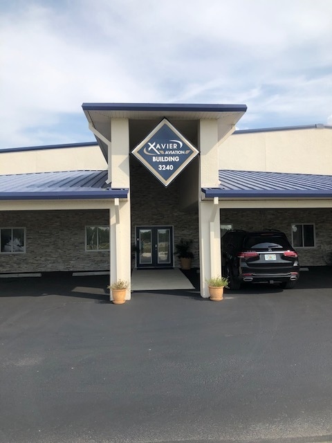
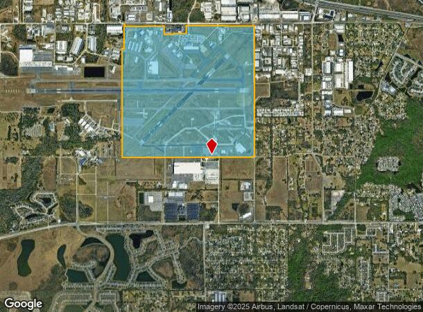
2925 Airside Center Dr
23-29-04-000000-011010
Lakeland Municipal Airport
Municipalproperty
LL LESS 4 AC FOR RD & LESS A PORTION OF LAKELAND AIRPARK AS RECORDED IN PB 81 PG 18 & LESS COMM NW COR OF SEC RUN S89-53-52E ALONG N LINE OF SEC 2037.01 FT S TO PT ON S MAINT R/W OF DRANE FIELD RD (SR 572) AS SHOWN IN MB 1 PGS 60-65 & TO POB RUN ALON
A
Polk
12105C0460G
Florida
0
626.03 AC
2025
Polk County
011902
Tampa/St Petersburg
432,927 SF
Lakeland-Winter Haven, FL
DEMOGRAPHICS near 2925 Airside Center Dr
1 Mile
3 Mile
5 Mile
2024 Total Population
319
27,970
111,466
2029 Population
383
33,456
131,936
Pop Growth 2024-2029
+ 20.06%
+ 19.61%
+ 18.36%
Average Age
37
43
40
2024 Total Households
106
11,582
43,547
HH Growth 2024-2029
+ 19.81%
+ 19.57%
+ 18.74%
Median Household Inc
$65,625
$65,185
$63,209
Avg Household Size
2.80
2.40
2.40
2024 Avg HH Vehicles
2.00
2.00
2.00
Median Home Value
$329,545
$225,659
$227,623
Median Year Built
1984
1988
1982
Nearby Places
Map Layers
Map Styles
 Street
 Aerial
- Restaurants
- Banks
- Shops
- Fitness
- Groceries
PUBLIC TRANSPORTATION
COMMUTER RAIL
Lakeland (Silver Star - Amtrak)
DRIVE
WALK
Distance
Lakeland (Silver Star - Amtrak)
15 min
7.5 mi
Freight Ports
Port of Tampa Bay
DRIVE
WALK
Distance
Port of Tampa Bay
47 min
34.6 mi
Nearby Properties
Address
Land Use
TOTAL SIZE
Lot Size
Zoning
Address
Land Use
TOTAL SIZE
Lot Size
Zoning
2,095,234 SF
102.45 AC
PUD
Address
Land Use
TOTAL SIZE
Lot Size
Zoning
518,028 SF
195.69 AC
Address
Land Use
TOTAL SIZE
Lot Size
Zoning
595,473 SF
47.29 AC
Address
Land Use
TOTAL SIZE
Lot Size
Zoning
315,901 SF
20.55 AC
Address
Land Use
TOTAL SIZE
Lot Size
Zoning
882,663 SF
133.57 AC
PUD
Address
Land Use
TOTAL SIZE
Lot Size
Zoning
602,125 SF
43.97 AC
Address
Land Use
TOTAL SIZE
Lot Size
Zoning
364,518 SF
23.38 AC
Address
Land Use
TOTAL SIZE
Lot Size
Zoning
417,890 SF
14.59 AC
Address
Land Use
TOTAL SIZE
Lot Size
Zoning
387,165 SF
37 AC
I2
Address
Land Use
TOTAL SIZE
Lot Size
Zoning
492,859 SF
135.58 AC
Address
Land Use
TOTAL SIZE
Lot Size
Zoning
296,264 SF
26.74 AC
Address
Land Use
TOTAL SIZE
Lot Size
Zoning
363,147 SF
76.15 AC
Address
Land Use
TOTAL SIZE
Lot Size
Zoning
328,863 SF
38.87 AC
M-1A
Address
Land Use
TOTAL SIZE
Lot Size
Zoning
300,411 SF
18.77 AC
I
Address
Land Use
TOTAL SIZE
Lot Size
Zoning
333,560 SF
44.88 AC
IND
Address
Land Use
TOTAL SIZE
Lot Size
Zoning
221,500 SF
19.54 AC
XX
Address
Land Use
TOTAL SIZE
Lot Size
Zoning
200,200 SF
17.40 AC
XX
Address
Land Use
TOTAL SIZE
Lot Size
Zoning
76,250 SF
5.25 AC
Address
Land Use
TOTAL SIZE
Lot Size
Zoning
215,280 SF
19.73 AC
R2
Address
Land Use
TOTAL SIZE
Lot Size
Zoning
150,600 SF
7.89 AC
Address
Land Use
TOTAL SIZE
Lot Size
Zoning
148,100 SF
7.05 AC
Address
Land Use
TOTAL SIZE
Lot Size
Zoning
144,648 SF
8.84 AC
I
Address
Land Use
TOTAL SIZE
Lot Size
Zoning
112,538 SF
23.44 AC
Address
Land Use
TOTAL SIZE
Lot Size
Zoning
170,844 SF
200.53 AC
PUD
Address
Land Use
TOTAL SIZE
Lot Size
Zoning
63,740 SF
8.63 AC
Address
Land Use
TOTAL SIZE
Lot Size
Zoning
156,240 SF
12.18 AC
RE2
Address
Land Use
TOTAL SIZE
Lot Size
Zoning
278,400 SF
22.83 AC
XX
Address
Land Use
TOTAL SIZE
Lot Size
Zoning
101,103 SF
13.87 AC
Address
Land Use
TOTAL SIZE
Lot Size
Zoning
216,358 SF
135.58 AC
The World's #1 Commercial Real Estate Marketplace
Connect with us
© 2025 CoStar Group
The information above has been obtained from sources believed reliable. While we do not doubt its accuracy we have not verified it and make no guarantee, warranty or representation about it. It is your responsibility to independently confirm its accuracy and completeness. Any projections, opinions, assumptions, or estimates used are for example only and do not represent the current or future performance of the property. The value of this transaction to you depends on tax and other factors which should be evaluated by your tax, financial, and legal advisors. You and your advisors should conduct a careful, independent investigation of the property to determine to your satisfaction the suitability of the property for your needs.