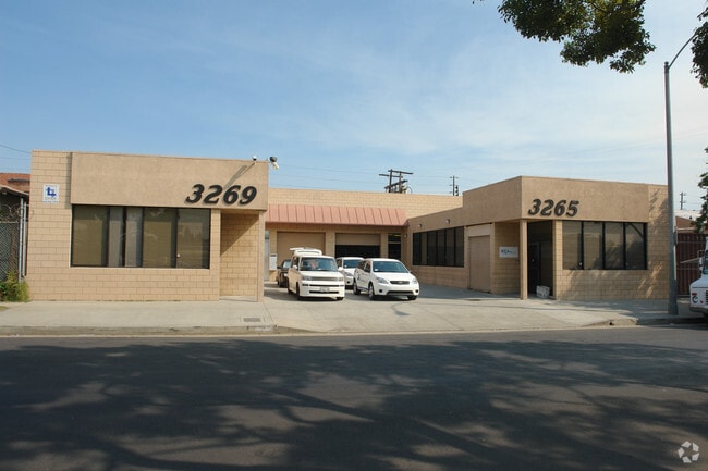
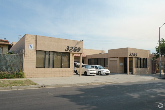
Property Record
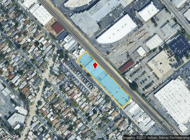
3265 Casitas Ave, Los Angeles, CA 90039
NEARBY LISTINGS FOR SALE OR LEASE
-
-
-
-
-
-
-
No Photo
-
-
-
-
-
-
View all Los Angeles listings for sale on LoopNet.com
Property Detail
3265 Casitas Ave
Los Angeles-Long Beach-Glendale, CA
4689
5436-002-027
TR=4689 LOTS 18 THRU 34 BLK B
Warehouse
Los Angeles
X
California
06037C1610F
18-34
2024
2.11 AC
2025
Glendale
187102
Los Angeles
56,506 SF
DEMOGRAPHICS near 3265 Casitas Ave
1 Mile
3 Mile
5 Mile
2024 Total Population
25,078
270,194
864,740
2029 Population
24,284
261,089
841,891
Pop Growth 2024-2029
(3.17%)
(3.37%)
(2.64%)
Average Age
41
41
40
2024 Total Households
9,386
109,768
353,419
HH Growth 2024-2029
(3.36%)
(3.62%)
(2.69%)
Median Household Inc
$87,489
$78,314
$63,952
Avg Household Size
2.60
2.40
2.30
2024 Avg HH Vehicles
2.00
2.00
1.00
Median Home Value
$908,550
$939,760
$938,386
Median Year Built
1957
1957
1962
Nearby Places
Map Layers
Map Styles
 Street
 Aerial
- Restaurants
- Banks
- Shops
- Fitness
- Groceries
PUBLIC TRANSPORTATION
COMMUTER RAIL
Glendale (Antelope Valley Line - Southern California Regional Rail Authority (Metrolink), Ventura County Line - Southern California Regional Rail Authority (Metrolink))
DRIVE
WALK
Distance
Glendale (Antelope Valley Line - Southern California Regional Rail Authority (Metrolink), Ventura County Line - Southern California Regional Rail Authority (Metrolink))
4 min
1.1 mi
Union Station (91 Line - Southern California Regional Rail Authority (Metrolink), Antelope Valley Line - Southern California Regional Rail Authority (Metrolink), Orange County Line - Southern California Regional Rail Authority (Metrolink), Riverside Line - Southern California Regional Rail Authority (Metrolink), San Bernardino Line - Southern California Regional Rail Authority (Metrolink), Ventura County Line - Southern California Regional Rail Authority (Metrolink))
DRIVE
WALK
Distance
Union Station (91 Line - Southern California Regional Rail Authority (Metrolink), Antelope Valley Line - Southern California Regional Rail Authority (Metrolink), Orange County Line - Southern California Regional Rail Authority (Metrolink), Riverside Line - Southern California Regional Rail Authority (Metrolink), San Bernardino Line - Southern California Regional Rail Authority (Metrolink), Ventura County Line - Southern California Regional Rail Authority (Metrolink))
14 min
5.8 mi
AIRPORT
Bob Hope
DRIVE
WALK
Distance
Bob Hope
19 min
12.6 mi
Los Angeles International
DRIVE
WALK
Distance
Los Angeles International
34 min
20.2 mi
Long Beach (Daugherty Field)
DRIVE
WALK
Distance
Long Beach (Daugherty Field)
39 min
26.6 mi
Freight Ports
Port of Long Beach
DRIVE
WALK
Distance
Port of Long Beach
41 min
29.4 mi
Nearby Properties
Address
Land Use
TOTAL SIZE
Lot Size
Zoning
Address
Land Use
TOTAL SIZE
Lot Size
Zoning
930,249 SF
7.39 AC
LAC2
Address
Land Use
TOTAL SIZE
Lot Size
Zoning
709,584 SF
1.80 AC
LAPB
Address
Land Use
TOTAL SIZE
Lot Size
Zoning
272,288 SF
24.26 AC
GLC3-C2-R4
Address
Land Use
TOTAL SIZE
Lot Size
Zoning
590,292 SF
8.21 AC
GLC3*
Address
Land Use
TOTAL SIZE
Lot Size
Zoning
477,885 SF
2.52 AC
GLC3*
Address
Land Use
TOTAL SIZE
Lot Size
Zoning
406,948 SF
8.04 AC
LAC2
Address
Land Use
TOTAL SIZE
Lot Size
Zoning
920,082 SF
2.51 AC
GLC2-R4*
Address
Land Use
TOTAL SIZE
Lot Size
Zoning
309,008 SF
11.91 AC
LAM3
Address
Land Use
TOTAL SIZE
Lot Size
Zoning
251,317 SF
114.56 AC
LAR1
Address
Land Use
TOTAL SIZE
Lot Size
Zoning
985,517 SF
4.08 AC
GLC3
Address
Land Use
TOTAL SIZE
Lot Size
Zoning
349,519 SF
2.16 AC
GLM1*
Address
Land Use
TOTAL SIZE
Lot Size
Zoning
317,292 SF
36.67 AC
LAM3
Address
Land Use
TOTAL SIZE
Lot Size
Zoning
251,159 SF
2.84 AC
LAPB
Address
Land Use
TOTAL SIZE
Lot Size
Zoning
245,031 SF
2.21 AC
GLM2
Address
Land Use
TOTAL SIZE
Lot Size
Zoning
235,936 SF
1.58 AC
GLC2*
Address
Land Use
TOTAL SIZE
Lot Size
Zoning
457,694 SF
1.42 AC
GLC3*
Address
Land Use
TOTAL SIZE
Lot Size
Zoning
265,301 SF
0.17 AC
GLC3*
Address
Land Use
TOTAL SIZE
Lot Size
Zoning
122,988 SF
3.32 AC
GLC3*
Address
Land Use
TOTAL SIZE
Lot Size
Zoning
766,497 SF
2.10 AC
GLC2*
Address
Land Use
TOTAL SIZE
Lot Size
Zoning
220,624 SF
1.50 AC
GLC3-C2*
Address
Land Use
TOTAL SIZE
Lot Size
Zoning
638,414 SF
2.53 AC
GLC3-C2*
Address
Land Use
TOTAL SIZE
Lot Size
Zoning
86,522 SF
21.02 AC
LAM1
Address
Land Use
TOTAL SIZE
Lot Size
Zoning
214,087 SF
1.65 AC
GLC3*
Address
Land Use
TOTAL SIZE
Lot Size
Zoning
43,526 SF
2.80 AC
LAC2
Address
Land Use
TOTAL SIZE
Lot Size
Zoning
223,599 SF
1.43 AC
GLC3*
Address
Land Use
TOTAL SIZE
Lot Size
Zoning
131,790 SF
1.31 AC
LARD1.5
Address
Land Use
TOTAL SIZE
Lot Size
Zoning
189,663 SF
1.36 AC
GLC2*
Address
Land Use
TOTAL SIZE
Lot Size
Zoning
779,800 SF
5.39 AC
GLC2-C3*
Address
Land Use
TOTAL SIZE
Lot Size
Zoning
126,452 SF
9.27 AC
GLM2*
Address
Land Use
TOTAL SIZE
Lot Size
Zoning
212,943 SF
1.41 AC
GLC3-R4*
The World's #1 Commercial Real Estate Marketplace
Connect with us
© 2025 CoStar Group
The information above has been obtained from sources believed reliable. While we do not doubt its accuracy we have not verified it and make no guarantee, warranty or representation about it. It is your responsibility to independently confirm its accuracy and completeness. Any projections, opinions, assumptions, or estimates used are for example only and do not represent the current or future performance of the property. The value of this transaction to you depends on tax and other factors which should be evaluated by your tax, financial, and legal advisors. You and your advisors should conduct a careful, independent investigation of the property to determine to your satisfaction the suitability of the property for your needs.