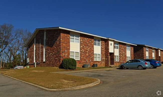
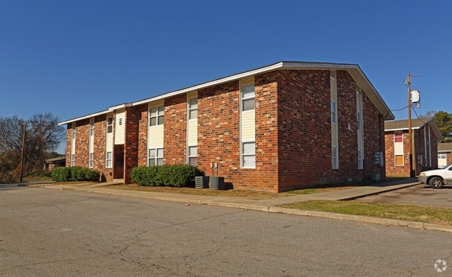
Property Record
3245 Lucius Rd, Columbia, SC 29201


Save to a Folder
{{folder.Name}}
{{folder.ListingIds.length}} Properties
{{folder.ListingIds.length}} Property
Create a New Folder
Property Detail
3245 Lucius Rd
09101-01-03
C & PT TRACT A BROAD RIVER TERRACE RENAMED RIVERSIDE APTS #PR 34-440 X-447
Apartment
Richland
RG-2
South Carolina
C and X Area of minimal flood hazard, usually depicted on FIRMs as above the 500-year flood level.
6.99 AC
0
Laurel Hill
2025
Columbia
000600
Columbia, SC
95,254 SF
NEARBY LISTINGS FOR SALE OR LEASE
DEMOGRAPHICS near 3245 Lucius Rd
1 mile
3 mile
5 mile
2025 Total Population
7,412
77,886
176,955
2030 Population
7,725
81,014
184,398
Pop Growth 2025-2030
+ 4.22%
+ 4.02%
+ 4.21%
Average Age
36
35
37
2025 Total Households
3,806
33,607
77,427
HH Growth 2025-2030
+ 4.23%
+ 4.34%
+ 4.56%
Median Household Inc
$67,881
$44,406
$50,881
Avg Household Size
1.90
2.00
2.00
2025 Avg HH Vehicles
1.00
1.00
2.00
Median Home Value
$263,200
$211,862
$221,933
Median Year Built
1974
1972
1971
Nearby Places
Map Layers
Map Styles
 Street
 Aerial
Layers
 Traffic
 Biking
Places
Listings with unknown addresses are not visible on the map
- Restaurants
- Banks
- Shops
- Fitness
- Groceries
PUBLIC TRANSPORTATION
COMMUTER RAIL
Columbia Amtrak Station (Silver Star - Amtrak)
Drive
Walk
Distance
Columbia Amtrak Station (Silver Star - Amtrak)
10 min
3.1 mi
AIRPORT
Columbia Metro
Drive
Walk
Distance
Columbia Metro
28 min
12.6 mi
Freight Ports
North Charleston Terminal
Drive
Walk
Distance
North Charleston Terminal
127 min
108.9 mi
Nearby Properties
Address
Land Use
TOTAL SIZE
Lot Size
Zoning
Address
Land Use
TOTAL SIZE
Lot Size
Zoning
30,100 SF
3.45 AC
M-2
Address
Land Use
TOTAL SIZE
Lot Size
Zoning
501,365 SF
13.28 AC
O-I
Address
Land Use
TOTAL SIZE
Lot Size
Zoning
106,284 SF
10.83 AC
C-5
Address
Land Use
TOTAL SIZE
Lot Size
Zoning
100 SF
15.17 AC
C-1
Address
Land Use
TOTAL SIZE
Lot Size
Zoning
456,218 SF
1 AC
DAC
Address
Land Use
TOTAL SIZE
Lot Size
Zoning
413,000 SF
3.48 AC
MC
Address
Land Use
TOTAL SIZE
Lot Size
Zoning
160,510 SF
0.26 AC
DAC
Address
Land Use
TOTAL SIZE
Lot Size
Zoning
311,754 SF
1.78 AC
DAC
Address
Land Use
TOTAL SIZE
Lot Size
Zoning
440,418 SF
7.23 AC
M-1
Address
Land Use
TOTAL SIZE
Lot Size
Zoning
375,417 SF
3.92 AC
INS-GEN
Address
Land Use
TOTAL SIZE
Lot Size
Zoning
2.07 AC
DAC
Address
Land Use
TOTAL SIZE
Lot Size
Zoning
119,738 SF
10.30 AC
EC
Address
Land Use
TOTAL SIZE
Lot Size
Zoning
358,561 SF
42.10 AC
EC
Address
Land Use
TOTAL SIZE
Lot Size
Zoning
204,154 SF
1.37 AC
DAC
Address
Land Use
TOTAL SIZE
Lot Size
Zoning
530,349 SF
0.75 AC
DAC
Address
Land Use
TOTAL SIZE
Lot Size
Zoning
100 SF
9.81 AC
MC
Address
Land Use
TOTAL SIZE
Lot Size
Zoning
353,447 SF
0.53 AC
DAC
Address
Land Use
TOTAL SIZE
Lot Size
Zoning
20,434 SF
17.20 AC
C-1
Address
Land Use
TOTAL SIZE
Lot Size
Zoning
383,491 SF
2.36 AC
C-3
Address
Land Use
TOTAL SIZE
Lot Size
Zoning
311,168 SF
3.98 AC
MC
Address
Land Use
TOTAL SIZE
Lot Size
Zoning
494,384 SF
1.67 AC
MC
Address
Land Use
TOTAL SIZE
Lot Size
Zoning
291,996 SF
0.78 AC
DAC
Address
Land Use
TOTAL SIZE
Lot Size
Zoning
354,235 SF
0.80 AC
DAC
Address
Land Use
TOTAL SIZE
Lot Size
Zoning
490,633 SF
13.20 AC
RM-2
Address
Land Use
TOTAL SIZE
Lot Size
Zoning
163,868 SF
4.35 AC
CAC
Address
Land Use
TOTAL SIZE
Lot Size
Zoning
90,588 SF
3.72 AC
DAC
Address
Land Use
TOTAL SIZE
Lot Size
Zoning
85,065 SF
2.43 AC
C-1
Address
Land Use
TOTAL SIZE
Lot Size
Zoning
100 SF
0.52 AC
C-1
Address
Land Use
TOTAL SIZE
Lot Size
Zoning
100 SF
4.49 AC
INS-GEN
Address
Land Use
TOTAL SIZE
Lot Size
Zoning
221,186 SF
1.31 AC
DAC
The World's #1 Commercial Real Estate Marketplace
Connect with us
© 2026 CoStar Group
The information above has been obtained from sources believed reliable. While we do not doubt its accuracy we have not verified it and make no guarantee, warranty or representation about it. It is your responsibility to independently confirm its accuracy and completeness. Any projections, opinions, assumptions, or estimates used are for example only and do not represent the current or future performance of the property. The value of this transaction to you depends on tax and other factors which should be evaluated by your tax, financial, and legal advisors. You and your advisors should conduct a careful, independent investigation of the property to determine to your satisfaction the suitability of the property for your needs.