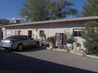
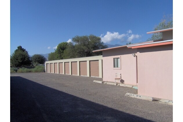
Property Record
3245 W Main St, Thatcher, AZ 85552


Save to a Folder
{{folder.Name}}
{{folder.ListingIds.length}} Properties
{{folder.ListingIds.length}} Property
Create a New Folder
Property Detail
3245 W Main St
104-09-022
BEG PNT 9RDS 4: 4IN E NW COR LOT 3 BLK 16 THATCHER TH E 6RDS 12: 2IN TO NE COR LOT 3 TH S 16RDS; TH W 6RDS 12: 2IN TH N 16RDS TO POB EXC THAT PART OF BLOCK 16 TOWN OF THATCHER SEC 2 T7S R25E COM NE COR BLOCK 16 TH N89D50'43"W 263.11' TO NE COR LOT 3
Commercialnec
Graham
B and X Area of moderate flood hazard, usually the area between the limits of the 100-year and 500-year floods.
Arizona
2024
3
2026
0.63 AC
961201
Other Market Areas
8,515 SF
Safford, AZ
NEARBY LISTINGS FOR SALE OR LEASE
-
-
View all Thatcher listings for sale on LoopNet.com
DEMOGRAPHICS near 3245 W Main St
1 mile
3 mile
5 mile
2025 Total Population
3,105
13,614
23,051
2030 Population
2,993
13,967
23,915
Pop Growth 2025-2030
(3.61%)
+ 2.59%
+ 3.75%
Average Age
33
37
37
2025 Total Households
1,019
4,894
8,174
HH Growth 2025-2030
(3.73%)
+ 2.96%
+ 3.93%
Median Household Inc
$83,422
$68,729
$67,208
Avg Household Size
2.90
2.70
2.80
2025 Avg HH Vehicles
2.00
2.00
2.00
Median Home Value
$361,299
$248,921
$233,416
Median Year Built
1993
1988
1989
Nearby Places
Map Layers
Map Styles
 Street
 Aerial
Layers
 Traffic
 Biking
Places
Listings with unknown addresses are not visible on the map
- Restaurants
- Banks
- Shops
- Fitness
- Groceries
Nearby Properties
Address
Land Use
TOTAL SIZE
Lot Size
Zoning
Address
Land Use
TOTAL SIZE
Lot Size
Zoning
58,561 SF
11.75 AC
Address
Land Use
TOTAL SIZE
Lot Size
Zoning
207,922 SF
21.39 AC
Address
Land Use
TOTAL SIZE
Lot Size
Zoning
108,180 SF
47.47 AC
Address
Land Use
TOTAL SIZE
Lot Size
Zoning
95,920 SF
12.23 AC
Address
Land Use
TOTAL SIZE
Lot Size
Zoning
33,539 SF
22.26 AC
Address
Land Use
TOTAL SIZE
Lot Size
Zoning
94,361 SF
10.65 AC
Address
Land Use
TOTAL SIZE
Lot Size
Zoning
128,419 SF
7.43 AC
Address
Land Use
TOTAL SIZE
Lot Size
Zoning
65,939 SF
4.97 AC
Address
Land Use
TOTAL SIZE
Lot Size
Zoning
49,283 SF
20.35 AC
Address
Land Use
TOTAL SIZE
Lot Size
Zoning
48,494 SF
11.13 AC
Address
Land Use
TOTAL SIZE
Lot Size
Zoning
56,564 SF
5.27 AC
Address
Land Use
TOTAL SIZE
Lot Size
Zoning
17,725 SF
8.70 AC
Address
Land Use
TOTAL SIZE
Lot Size
Zoning
64,022 SF
3.43 AC
Address
Land Use
TOTAL SIZE
Lot Size
Zoning
49,585 SF
4.95 AC
Address
Land Use
TOTAL SIZE
Lot Size
Zoning
43,932 SF
1.94 AC
Address
Land Use
TOTAL SIZE
Lot Size
Zoning
43,932 SF
2.26 AC
Address
Land Use
TOTAL SIZE
Lot Size
Zoning
22,912 SF
2.87 AC
Address
Land Use
TOTAL SIZE
Lot Size
Zoning
42,672 SF
7.56 AC
Address
Land Use
TOTAL SIZE
Lot Size
Zoning
104,895 SF
7.94 AC
Address
Land Use
TOTAL SIZE
Lot Size
Zoning
31,613 SF
1.59 AC
Address
Land Use
TOTAL SIZE
Lot Size
Zoning
21,435 SF
264.62 AC
Address
Land Use
TOTAL SIZE
Lot Size
Zoning
18,687 SF
0.17 AC
Address
Land Use
TOTAL SIZE
Lot Size
Zoning
59,698 SF
6.02 AC
Address
Land Use
TOTAL SIZE
Lot Size
Zoning
45,764 SF
3.03 AC
Address
Land Use
TOTAL SIZE
Lot Size
Zoning
36,448 SF
4.52 AC
Address
Land Use
TOTAL SIZE
Lot Size
Zoning
27,946 SF
0.75 AC
Address
Land Use
TOTAL SIZE
Lot Size
Zoning
44,150 SF
2.23 AC
Address
Land Use
TOTAL SIZE
Lot Size
Zoning
105,798 SF
4.64 AC
Address
Land Use
TOTAL SIZE
Lot Size
Zoning
36,565 SF
2.57 AC
Address
Land Use
TOTAL SIZE
Lot Size
Zoning
13,280 SF
1.99 AC
The World's #1 Commercial Real Estate Marketplace
Connect with us
© 2026 CoStar Group
The information above has been obtained from sources believed reliable. While we do not doubt its accuracy we have not verified it and make no guarantee, warranty or representation about it. It is your responsibility to independently confirm its accuracy and completeness. Any projections, opinions, assumptions, or estimates used are for example only and do not represent the current or future performance of the property. The value of this transaction to you depends on tax and other factors which should be evaluated by your tax, financial, and legal advisors. You and your advisors should conduct a careful, independent investigation of the property to determine to your satisfaction the suitability of the property for your needs.