Property Record
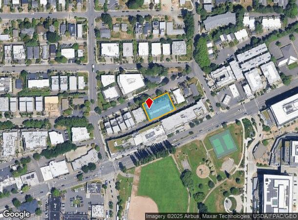
325 4Th Ave, Kirkland, WA 98033
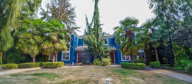
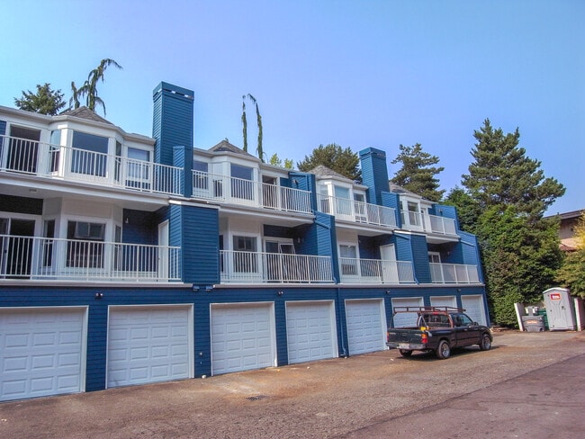
This Property Is For Sale
NEARBY LISTINGS FOR SALE OR LEASE
Property Detail
325 4Th Ave
Seattle-Tacoma-Bellevue, WA
Kirkland Terrace Add
390010-1211
King
Condominium
Washington
X
0.35 AC
53033C0365G
Downtown Kirkland
8,700 SF
Seattle/Puget Sound
DEMOGRAPHICS near 325 4Th Ave
1 Mile
3 Mile
5 Mile
2024 Total Population
16,962
91,472
307,344
2029 Population
17,240
92,781
311,661
Pop Growth 2024-2029
+ 1.64%
+ 1.43%
+ 1.40%
Average Age
42
39
39
2024 Total Households
8,000
38,376
128,310
HH Growth 2024-2029
+ 1.60%
+ 1.37%
+ 1.49%
Median Household Inc
$152,301
$140,253
$146,089
Avg Household Size
2.10
2.30
2.30
2024 Avg HH Vehicles
2.00
2.00
2.00
Median Home Value
$1,090,144
$1,031,755
$1,012,901
Median Year Built
1990
1984
1985
Nearby Places
- Restaurants
- Banks
- Shops
- Fitness
- Groceries
PUBLIC TRANSPORTATION
AIRPORT
Seattle Paine Field International
DRIVE
WALK
Distance
Seattle Paine Field International
29 min
19.7 mi
Seattle-Tacoma International
DRIVE
WALK
Distance
Seattle-Tacoma International
33 min
22.1 mi
Freight Ports
Port of Seattle
DRIVE
WALK
Distance
Port of Seattle
27 min
15.8 mi
Nearby Properties
Address
Land Use
TOTAL SIZE
Lot Size
Zoning
Address
Land Use
TOTAL SIZE
Lot Size
Zoning
26,850 SF
194.66 AC
NR2
Address
Land Use
TOTAL SIZE
Lot Size
Zoning
570,472 SF
17.39 AC
TL 3A
Address
Land Use
TOTAL SIZE
Lot Size
Zoning
50,060 SF
96.12 AC
NR2
Address
Land Use
TOTAL SIZE
Lot Size
Zoning
105,056 SF
15.92 AC
PLA 15A
Address
Land Use
TOTAL SIZE
Lot Size
Zoning
407,216 SF
45.12 AC
PLA 9
Address
Land Use
TOTAL SIZE
Lot Size
Zoning
301,245 SF
22.34 AC
LR3 (M)
Address
Land Use
TOTAL SIZE
Lot Size
Zoning
747,347 SF
8.91 AC
BP
Address
Land Use
TOTAL SIZE
Lot Size
Zoning
295,212 SF
10.57 AC
PLA 3B
Address
Land Use
TOTAL SIZE
Lot Size
Zoning
11,970 SF
4.81 AC
TL 6A
Address
Land Use
TOTAL SIZE
Lot Size
Zoning
572,539 SF
2.50 AC
CBD 5A
Address
Land Use
TOTAL SIZE
Lot Size
Zoning
279,488 SF
20.82 AC
NMF
Address
Land Use
TOTAL SIZE
Lot Size
Zoning
240 SF
471.44 AC
R1
Address
Land Use
TOTAL SIZE
Lot Size
Zoning
212,688 SF
1.46 AC
JBD 1
Address
Land Use
TOTAL SIZE
Lot Size
Zoning
177,772 SF
2.03 AC
JBD 1
Address
Land Use
TOTAL SIZE
Lot Size
Zoning
7,381 SF
1.30 AC
CBD 1B
Address
Land Use
TOTAL SIZE
Lot Size
Zoning
159,152 SF
2.83 AC
JBD 1
Address
Land Use
TOTAL SIZE
Lot Size
Zoning
272,800 SF
19.26 AC
RM 2.4
Address
Land Use
TOTAL SIZE
Lot Size
Zoning
73,729 SF
42.57 AC
RSX 7.2
Address
Land Use
TOTAL SIZE
Lot Size
Zoning
444,618 SF
4.78 AC
PLA 6G
Address
Land Use
TOTAL SIZE
Lot Size
Zoning
100,736 SF
0.96 AC
CBD 1B
Address
Land Use
TOTAL SIZE
Lot Size
Zoning
65,622 SF
6.20 AC
LIT
Address
Land Use
TOTAL SIZE
Lot Size
Zoning
187,860 SF
12.68 AC
TL 11
Address
Land Use
TOTAL SIZE
Lot Size
Zoning
43,016 SF
10.33 AC
TL 2
Address
Land Use
TOTAL SIZE
Lot Size
Zoning
1.62 AC
NWDD
Address
Land Use
TOTAL SIZE
Lot Size
Zoning
134,918 SF
1.55 AC
CBD 6
Address
Land Use
TOTAL SIZE
Lot Size
Zoning
220,523 SF
11.63 AC
BP
Address
Land Use
TOTAL SIZE
Lot Size
Zoning
185,400 SF
8.05 AC
RM 1.8
Address
Land Use
TOTAL SIZE
Lot Size
Zoning
324,923 SF
2.85 AC
LIT
Address
Land Use
TOTAL SIZE
Lot Size
Zoning
214,827 SF
10.27 AC
PLA 14
Address
Land Use
TOTAL SIZE
Lot Size
Zoning
143,284 SF
5.73 AC
BP
The World's #1 Commercial Real Estate Marketplace
Connect with us
© 2025 CoStar Group
The information above has been obtained from sources believed reliable. While we do not doubt its accuracy we have not verified it and make no guarantee, warranty or representation about it. It is your responsibility to independently confirm its accuracy and completeness. Any projections, opinions, assumptions, or estimates used are for example only and do not represent the current or future performance of the property. The value of this transaction to you depends on tax and other factors which should be evaluated by your tax, financial, and legal advisors. You and your advisors should conduct a careful, independent investigation of the property to determine to your satisfaction the suitability of the property for your needs.