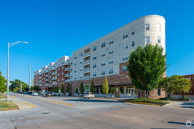
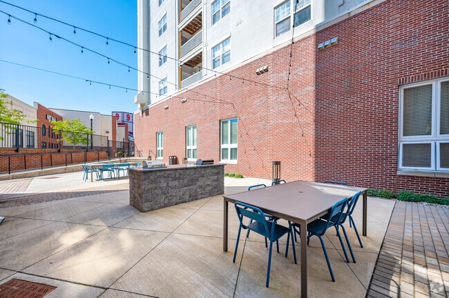
Property Record
325 Brown St, West Lafayette, IN 47906
NEARBY LISTINGS FOR SALE OR LEASE
Property Detail
325 Brown St
Lafayette-West Lafayette, IN
Wabash Landing Apartments Extension Pd
79-07-20-330-010.000-026
WABASH LANDING APARTMENTS EXTENSION PD LOT 1D
Apartment
Tippecanoe
X
Indiana
18157C0142D
1d
2024
0.74 AC
2024
Downtown West Lafayette
005402
Other Market Areas
81,265 SF
DEMOGRAPHICS near 325 Brown St
1 Mile
3 Mile
5 Mile
2024 Total Population
20,987
84,323
144,541
2029 Population
21,868
87,171
149,152
Pop Growth 2024-2029
+ 4.20%
+ 3.38%
+ 3.19%
Average Age
29
33
34
2024 Total Households
9,866
33,982
58,663
HH Growth 2024-2029
+ 4.37%
+ 3.84%
+ 3.50%
Median Household Inc
$23,646
$39,390
$47,488
Avg Household Size
1.90
2.10
2.20
2024 Avg HH Vehicles
1.00
2.00
2.00
Median Home Value
$181,432
$157,185
$180,774
Median Year Built
1982
1971
1984
Nearby Places
Map Layers
Map Styles
 Street
 Aerial
- Restaurants
- Banks
- Shops
- Fitness
- Groceries
PUBLIC TRANSPORTATION
COMMUTER RAIL
Lafayette Amtrak Station (Cardinal - Amtrak)
DRIVE
WALK
Distance
Lafayette Amtrak Station (Cardinal - Amtrak)
2 min
7 min
0.4 mi
Freight Ports
Port Milwaukee
DRIVE
WALK
Distance
Port Milwaukee
251 min
206.5 mi
Nearby Properties
Address
Land Use
TOTAL SIZE
Lot Size
Zoning
Address
Land Use
TOTAL SIZE
Lot Size
Zoning
469,872 SF
0.85 AC
Address
Land Use
TOTAL SIZE
Lot Size
Zoning
377,937 SF
4.80 AC
Address
Land Use
TOTAL SIZE
Lot Size
Zoning
385,162 SF
1 AC
Address
Land Use
TOTAL SIZE
Lot Size
Zoning
401,345 SF
1.64 AC
Address
Land Use
TOTAL SIZE
Lot Size
Zoning
498,665 SF
1.94 AC
Address
Land Use
TOTAL SIZE
Lot Size
Zoning
Address
Land Use
TOTAL SIZE
Lot Size
Zoning
417,720 SF
3.09 AC
Address
Land Use
TOTAL SIZE
Lot Size
Zoning
13,773 SF
87 SF
Address
Land Use
TOTAL SIZE
Lot Size
Zoning
249,214 SF
1.93 AC
Address
Land Use
TOTAL SIZE
Lot Size
Zoning
159,946 SF
87 SF
Address
Land Use
TOTAL SIZE
Lot Size
Zoning
267,566 SF
18.99 AC
Address
Land Use
TOTAL SIZE
Lot Size
Zoning
402,757 SF
23.10 AC
Address
Land Use
TOTAL SIZE
Lot Size
Zoning
159,723 SF
4.87 AC
Address
Land Use
TOTAL SIZE
Lot Size
Zoning
148,860 SF
1.25 AC
Address
Land Use
TOTAL SIZE
Lot Size
Zoning
0.01 AC
Address
Land Use
TOTAL SIZE
Lot Size
Zoning
232,565 SF
1.15 AC
Address
Land Use
TOTAL SIZE
Lot Size
Zoning
8,675 SF
0.02 AC
Address
Land Use
TOTAL SIZE
Lot Size
Zoning
1,449,360 SF
0.01 AC
Address
Land Use
TOTAL SIZE
Lot Size
Zoning
205,701 SF
1.27 AC
Address
Land Use
TOTAL SIZE
Lot Size
Zoning
27,300 SF
22.52 AC
Address
Land Use
TOTAL SIZE
Lot Size
Zoning
164,234 SF
0.88 AC
Address
Land Use
TOTAL SIZE
Lot Size
Zoning
184,441 SF
44 SF
Address
Land Use
TOTAL SIZE
Lot Size
Zoning
222,276 SF
0.31 AC
Address
Land Use
TOTAL SIZE
Lot Size
Zoning
203,830 SF
18.73 AC
Address
Land Use
TOTAL SIZE
Lot Size
Zoning
113,044 SF
44 SF
Address
Land Use
TOTAL SIZE
Lot Size
Zoning
42,800 SF
131 SF
Address
Land Use
TOTAL SIZE
Lot Size
Zoning
141,960 SF
2.27 AC
Address
Land Use
TOTAL SIZE
Lot Size
Zoning
118,066 SF
0.80 AC
Address
Land Use
TOTAL SIZE
Lot Size
Zoning
135,090 SF
0.80 AC
The World's #1 Commercial Real Estate Marketplace
Connect with us
© 2026 CoStar Group
The information above has been obtained from sources believed reliable. While we do not doubt its accuracy we have not verified it and make no guarantee, warranty or representation about it. It is your responsibility to independently confirm its accuracy and completeness. Any projections, opinions, assumptions, or estimates used are for example only and do not represent the current or future performance of the property. The value of this transaction to you depends on tax and other factors which should be evaluated by your tax, financial, and legal advisors. You and your advisors should conduct a careful, independent investigation of the property to determine to your satisfaction the suitability of the property for your needs.