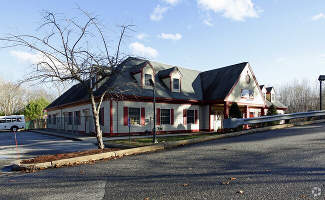
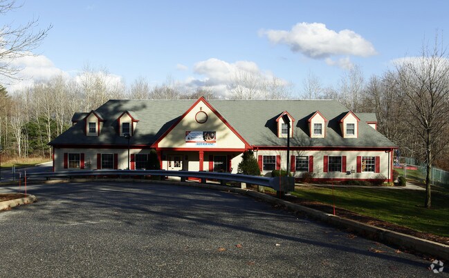
Property Record
325 Daniel Webster Hwy, Merrimack, NH 03054
NEARBY LISTINGS FOR SALE OR LEASE
Property Detail
325 Daniel Webster Hwy
MRMK-000404D-000049
Hillsborough
Commercialbuilding
New Hampshire
X
49
33011C0503D
1.02 AC
2024
Hillsborough
2024
Boston
014102
Manchester-Nashua, NH
6,517 SF
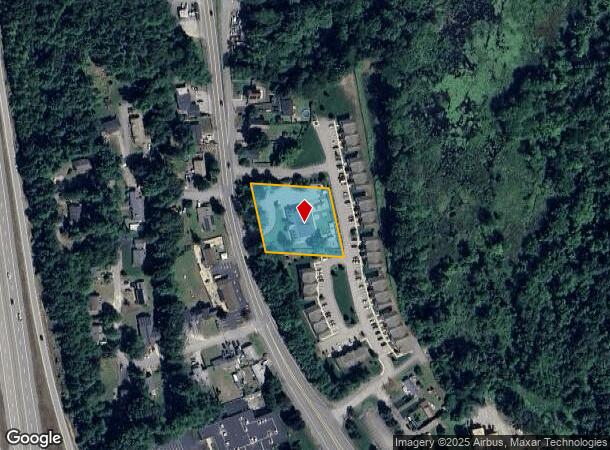
DEMOGRAPHICS near 325 Daniel Webster Hwy
1 Mile
3 Mile
5 Mile
2024 Total Population
4,549
22,008
65,625
2029 Population
4,759
22,669
67,458
Pop Growth 2024-2029
+ 4.62%
+ 3.00%
+ 2.79%
Average Age
42
42
42
2024 Total Households
1,803
8,339
25,534
HH Growth 2024-2029
+ 4.77%
+ 3.05%
+ 2.84%
Median Household Inc
$128,876
$122,022
$113,879
Avg Household Size
2.50
2.60
2.50
2024 Avg HH Vehicles
2.00
2.00
2.00
Median Home Value
$394,517
$384,715
$386,347
Median Year Built
1987
1985
1983
Nearby Places
Map Layers
Map Styles
 Street
 Aerial
- Restaurants
- Banks
- Shops
- Fitness
- Groceries
PUBLIC TRANSPORTATION
AIRPORT
Manchester Boston Regional
DRIVE
WALK
Distance
Manchester Boston Regional
16 min
9.1 mi
SALE & LEASE HISTORY
LISTING DATE
SALE/LEASE

Sep 23, 2016
For Sale
Nearby Properties
Address
Land Use
TOTAL SIZE
Lot Size
Zoning
Address
Land Use
TOTAL SIZE
Lot Size
Zoning
29,295 SF
143.99 AC
INDUST
Address
Land Use
TOTAL SIZE
Lot Size
Zoning
202,546 SF
55 AC
RESIDE
Address
Land Use
TOTAL SIZE
Lot Size
Zoning
3,615 SF
21.02 AC
C2- GE
Address
Land Use
TOTAL SIZE
Lot Size
Zoning
6.28 AC
INDUST
Address
Land Use
TOTAL SIZE
Lot Size
Zoning
576,827 SF
446.22 AC
INDUST
Address
Land Use
TOTAL SIZE
Lot Size
Zoning
621,927 SF
106.62 AC
INDUST
Address
Land Use
TOTAL SIZE
Lot Size
Zoning
15,975 SF
195.68 AC
INDUST
Address
Land Use
TOTAL SIZE
Lot Size
Zoning
471,525 SF
40.78 AC
INDUST
Address
Land Use
TOTAL SIZE
Lot Size
Zoning
51,684 SF
36.58 AC
INDUST
Address
Land Use
TOTAL SIZE
Lot Size
Zoning
326,755 SF
43 AC
INDUST
Address
Land Use
TOTAL SIZE
Lot Size
Zoning
123,648 SF
135.87 AC
INDUST
Address
Land Use
TOTAL SIZE
Lot Size
Zoning
193,749 SF
54.34 AC
INDUST
Address
Land Use
TOTAL SIZE
Lot Size
Zoning
398,215 SF
65.88 AC
INDUST
Address
Land Use
TOTAL SIZE
Lot Size
Zoning
101,479 SF
11.52 AC
INDUST
Address
Land Use
TOTAL SIZE
Lot Size
Zoning
24,495 SF
13.05 AC
RESIDE
Address
Land Use
TOTAL SIZE
Lot Size
Zoning
5,894 SF
12.50 AC
RESIDE
Address
Land Use
TOTAL SIZE
Lot Size
Zoning
1.63 AC
RES
Address
Land Use
TOTAL SIZE
Lot Size
Zoning
38 AC
RES
Address
Land Use
TOTAL SIZE
Lot Size
Zoning
158,239 SF
21.41 AC
INDUST
Address
Land Use
TOTAL SIZE
Lot Size
Zoning
Address
Land Use
TOTAL SIZE
Lot Size
Zoning
70,301 SF
7.90 AC
INDUST
Address
Land Use
TOTAL SIZE
Lot Size
Zoning
70,098 SF
7.69 AC
C2- GE
Address
Land Use
TOTAL SIZE
Lot Size
Zoning
Address
Land Use
TOTAL SIZE
Lot Size
Zoning
79,492 SF
24.53 AC
RESIDE
Address
Land Use
TOTAL SIZE
Lot Size
Zoning
150,063 SF
8.46 AC
INDUST
Address
Land Use
TOTAL SIZE
Lot Size
Zoning
47,726 SF
1.70 AC
C2- GE
Address
Land Use
TOTAL SIZE
Lot Size
Zoning
93,403 SF
9.87 AC
INDUST
Address
Land Use
TOTAL SIZE
Lot Size
Zoning
6,182 SF
6 AC
INDUST
Address
Land Use
TOTAL SIZE
Lot Size
Zoning
69,031 SF
62.01 AC
RES
Address
Land Use
TOTAL SIZE
Lot Size
Zoning
119,806 SF
9.62 AC
INDUST
The World's #1 Commercial Real Estate Marketplace
Connect with us
© 2025 CoStar Group
The information above has been obtained from sources believed reliable. While we do not doubt its accuracy we have not verified it and make no guarantee, warranty or representation about it. It is your responsibility to independently confirm its accuracy and completeness. Any projections, opinions, assumptions, or estimates used are for example only and do not represent the current or future performance of the property. The value of this transaction to you depends on tax and other factors which should be evaluated by your tax, financial, and legal advisors. You and your advisors should conduct a careful, independent investigation of the property to determine to your satisfaction the suitability of the property for your needs.