Property Record
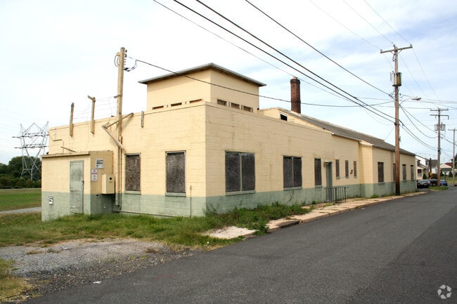
325 Front St, Perryville, MD 21903


Property Detail
325 Front St
07-021674
.571 ACRE 325 FRONT STREET PERRYVILLE
Bartavern
CECIL
TC
Maryland
B and X Area of moderate flood hazard, usually the area between the limits of the 100-year and 500-year floods.
0.57 AC
2025
Cecil County
2025
Baltimore
031202
Philadelphia-Camden-Wilmington, PA-NJ-DE-MD
10,447 SF
NEARBY LISTINGS FOR SALE OR LEASE
-
-
View all Perryville listings for sale on LoopNet.com
DEMOGRAPHICS near 325 Front St
1 mile
3 mile
5 mile
2025 Total Population
3,811
20,334
31,450
2030 Population
3,909
20,782
32,222
Pop Growth 2025-2030
+ 2.57%
+ 2.20%
+ 2.45%
Average Age
46
44
44
2025 Total Households
1,668
8,455
12,877
HH Growth 2025-2030
+ 2.70%
+ 2.38%
+ 2.62%
Median Household Inc
$64,261
$91,584
$94,375
Avg Household Size
2.10
2.40
2.40
2025 Avg HH Vehicles
2.00
2.00
2.00
Median Home Value
$277,018
$335,928
$342,139
Median Year Built
1978
1986
1987
Nearby Places
Map Layers
Map Styles
 Street
 Aerial
Layers
 Traffic
 Biking
Places
Listings with unknown addresses are not visible on the map
- Restaurants
- Banks
- Shops
- Fitness
- Groceries
PUBLIC TRANSPORTATION
COMMUTER RAIL
Aberdeen (Penn Line - Maryland Area Regional Commuter Trains (The MARC))
Drive
Walk
Distance
Aberdeen (Penn Line - Maryland Area Regional Commuter Trains (The MARC))
15 min
7.9 mi
Freight Ports
Port Newark Container Terminal
Drive
Walk
Distance
Port Newark Container Terminal
22 min
12.6 mi
Nearby Properties
Address
Land Use
TOTAL SIZE
Lot Size
Zoning
Address
Land Use
TOTAL SIZE
Lot Size
Zoning
457,324 SF
43.13 AC
C2/L2
Address
Land Use
TOTAL SIZE
Lot Size
Zoning
866,826 SF
267.48 AC
L2
Address
Land Use
TOTAL SIZE
Lot Size
Zoning
349.76 AC
OS
Address
Land Use
TOTAL SIZE
Lot Size
Zoning
2,589 SF
57.19 AC
R2
Address
Land Use
TOTAL SIZE
Lot Size
Zoning
68,345 SF
30.07 AC
CEMUD
Address
Land Use
TOTAL SIZE
Lot Size
Zoning
149,622 SF
9.30 AC
GI
Address
Land Use
TOTAL SIZE
Lot Size
Zoning
100,444 SF
2.64 AC
RB
Address
Land Use
TOTAL SIZE
Lot Size
Zoning
113,412 SF
108 AC
R2
Address
Land Use
TOTAL SIZE
Lot Size
Zoning
103,470 SF
5.97 AC
R1
Address
Land Use
TOTAL SIZE
Lot Size
Zoning
426,275 SF
21.17 AC
GI
Address
Land Use
TOTAL SIZE
Lot Size
Zoning
28.03 AC
OS
Address
Land Use
TOTAL SIZE
Lot Size
Zoning
65,006 SF
29.63 AC
R1
Address
Land Use
TOTAL SIZE
Lot Size
Zoning
140,316 SF
36.71 AC
RM
Address
Land Use
TOTAL SIZE
Lot Size
Zoning
58,603 SF
13.26 AC
R1
Address
Land Use
TOTAL SIZE
Lot Size
Zoning
1,270 SF
61.42 AC
C
Address
Land Use
TOTAL SIZE
Lot Size
Zoning
213,790 SF
1.37 AC
RB
Address
Land Use
TOTAL SIZE
Lot Size
Zoning
184,116 SF
18.45 AC
GI
Address
Land Use
TOTAL SIZE
Lot Size
Zoning
78,944 SF
18.78 AC
GI
Address
Land Use
TOTAL SIZE
Lot Size
Zoning
4,800 SF
14.81 AC
C2
Address
Land Use
TOTAL SIZE
Lot Size
Zoning
18,944 SF
7.11 AC
GI
Address
Land Use
TOTAL SIZE
Lot Size
Zoning
24,000 SF
2.24 AC
C2
Address
Land Use
TOTAL SIZE
Lot Size
Zoning
20,000 SF
11.32 AC
RB
Address
Land Use
TOTAL SIZE
Lot Size
Zoning
55,825 SF
10.25 AC
RB
Address
Land Use
TOTAL SIZE
Lot Size
Zoning
20,674 SF
0.54 AC
RO
Address
Land Use
TOTAL SIZE
Lot Size
Zoning
31,116 SF
9.37 AC
C
Address
Land Use
TOTAL SIZE
Lot Size
Zoning
7,586 SF
2.20 AC
RO
Address
Land Use
TOTAL SIZE
Lot Size
Zoning
39,126 SF
3.96 AC
C
Address
Land Use
TOTAL SIZE
Lot Size
Zoning
11,749 SF
10.62 AC
GI
Address
Land Use
TOTAL SIZE
Lot Size
Zoning
24,000 SF
2.16 AC
C2
Address
Land Use
TOTAL SIZE
Lot Size
Zoning
15,344 SF
4.96 AC
MUD
The World's #1 Commercial Real Estate Marketplace
Connect with us
© 2026 CoStar Group
The information above has been obtained from sources believed reliable. While we do not doubt its accuracy we have not verified it and make no guarantee, warranty or representation about it. It is your responsibility to independently confirm its accuracy and completeness. Any projections, opinions, assumptions, or estimates used are for example only and do not represent the current or future performance of the property. The value of this transaction to you depends on tax and other factors which should be evaluated by your tax, financial, and legal advisors. You and your advisors should conduct a careful, independent investigation of the property to determine to your satisfaction the suitability of the property for your needs.